Overview
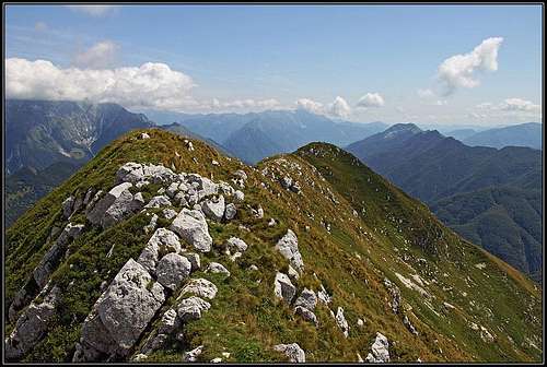
![On the W summit of Zaiavor/Zajavor]() On the summit ridge - looking towards the east
On the summit ridge - looking towards the eastAbout the name: Javor is a Slovenian word for maple tree and 'za' means behind. The Italian transcription is the obvious Zaiavor. On Tabacco map there is another secondary name - Zajauron - having an unknown origin.
Long crests, stretching in the east-west direction are characteristic for Julian Pre-Alps. The northernmost of them is the crest of
Muzci / Cime del Monte Musi, one of the wildest areas of the whole mountain group. And yet the first high summit on the east is accessible for almost everyone, provided a safe step on very steep grassy slopes. A marked path crosses the nearby notch and another branch of the path continues on top. Having also rocks in its steep slopes, Zajavor is predominantly grassy. Even if the highest summits of Muzci/Musi are only less than 100 meters higher, they are uncomparably harder to ascend. So, Zajavor offers also to hikers a good chance to know the new area and see Julian Alps from a different perspective.
Geography of the area is quite simple. The long ridge starts at the confluence of
Beli potok / Rio Bianco and
Učja/Uccea. After the summit of
Nizki vrh / Nischiuarch, there's the alpine
meadow of the same name on the ridge. Then a handful of unimportant summits are rising till the notch of
Zajavor (
Bochhetta di Zaiavor), 1608m. From it a steep grassy slope rises to the
eastern summit of Zajavor,
1815m, after which an almost horizontal ridge continues on the higher
western summit,
1830m. The path ends on the eastern summit and the cross stands there. But the higher western summit is easy to reach and the additional effort is also worthwile - only from there the wild central part of Muzci/Musi can be seen. The ridge further towards the west lowers, but also gets sharp and hard to be passed.
Beli potok / Rio Bianco actually has its source just below Zajavor summit. It is SE of it, in a valley where once shepherds huts of
Zajavor pasture stood. This valley is bordered by a ridge, descending from the summit of Zajavor down to the saddle
Tam na meji / Passo di Tanamea, delimiting Muzci/Musi range from Stol - Gran Monte range. Towards the west of this saddle a dry creek bed
Meja/Mea descends, forming the southern border of our mountain. Just north of Zajavor, Učja/Uccea creek has its sources below the pass of
Karnica / Sella Carnizza.
Summit Panorama
![Monte Canin/Kanin from Zajavor]() Monte Canin/Kanin massif from the summit of Zajavor
Monte Canin/Kanin massif from the summit of Zajavor![Monte Chiampon / Veliki Karman from Zajavor]() Monte Chiampon
Monte Chiampon![Monte Musi/Muzci from Zajavor]() Musi/Muzci
Musi/MuzciThe most attractive is the view on Kanin grop. Other long ridges of Julian Pre-Alps can be seen very well and behind them the plane of Furlania. Unusual is the view towards the west, on Muzci/Musi, which we see close enough and from a different angle. More towards the W and NW there are Carnic Alps, impressive is Zuc dal Bor group, behind we can see also other high Carnic mountains.
Getting There
![Sta. Anna di Carnizza]() Sta. Anna di Carnizza
Sta. Anna di Carnizza![Carnizza/Karnica saddle]() Carnizza/Karnica saddle
Carnizza/Karnica saddleSee the Julian Prealps page to learn how to reach the two passes where trailheads are.
Tam na meji / Tanamea pass connects the valleys of Torre/Ter and Soča/Isonzo. So, you can drive there from the south, from Tarcento/Čenta or from the east, from Bovec (you deter from Soča valley in Žaga). On this saddle there's the first trailhead, the path No. 727 goes from there towards the NW.
The second trailhead is on
Karnica / Sella Carnizza pass, 1086. Actually, you can drive a bit closer to the mountain, from
Njivica/Gnivizza meadow you you can drive good 500 meters towards the SE to the beautiful church of
Santa Anna di Carnizza, 1077m. Karnica saddle can also be reached from the east, from the valley of Soča, via Žaga and Učja/Uccea valley, or from the north-west, from the valley of Rezija/Resia. Of course, you can also get there from the south, from Tarcento, driving over Tam na meji / Tanamea pass and around on the northern side of the ridge.
Routes Overview
![Carnizza/Karnica saddle]() Northern ascent
Northern ascent![Zajavor E ridge]() Summit ridge
Summit ridgeAs you can see from the sketch, there are two marked paths on Zajavor (or one path, marked by
No. 727, crossing the ridge). They join on the notch east of the summit from where you have only the last 200 meters on top. The ascent till the notch is easy, the summit part goes over very steep grassy slopes, which can be dangerous in wet conditions and also when dry they require quite some care. But it's still only a hike.
1. From the north. From Santa Anna church the marked path soon enters the forrest. First it crosses the slopes towards the S and SE. After good 30 minutes the view opens, we are moving through rare last trees and bushes. The notch where we are heading is clearly seen above us. Don't worry about the steep terrain, the path will overcome it comfortably. First it gains altitude with several turns, finally it goes far to the right, then crosses the slope much to the left and in the last ascent comes on the notch.
2. From Tanamea pass (I haven't done the route). The trail starts some 100 meters from the building on the pass towards the west. In nice turns it goes first over the southern, then over the northern slopes of the ridge which descends from Zajavor. On some 1400 meters there is the ex alpine pasture from which the path continues in turns northwards on the 200 meters higher notch.
The
summit ascent follows the steep grassy ridge directly towards the west. The path is marked, actually following the deep steps in the grass is easy. But the path requires attention, because eventual mistake there would mean a fast and deep slide down the slopes. In dry conditions we still reach the summit cross without problems and can start enjoying the broad panorama. Only towards the west the nearby western summit is obscuring the view towards the central part of Muzci/Musi crest. So, it is certainly worth going there. The ridge is easy and with some care we are in 10 minutes on the highest point. Perhaps alone, because the majority of other visitors usually stays on the eastern summit.
To the cross on the eastern summit we would normally need 2 hours from Santa Anna (750m altitude difference) and 3 hours from Tanamea (970m of altitude difference).
Map: Tabacco 027 - Canin - Val Resia - Parco Naturale Prealpi Giulie
Huts and Camping
The ascent can be easilly done in half a day, so we don't need to sleep on the mountain. I have no information about the
Ricovero Casera Nischiuarch which is anyway not helping the ascent on Zajavor.
When To Climb?
Dry season is te best. Because the ascent is short, it can be done any time of the year. But the steep summit slopes require consideration. In snow you must have an ice pick and crampons. In ideal conditions skiing would be possible (requiring very good skills for the top slope), but the terrain below is not very attractive.
Your Help Needed
- Can you describe the hike approach from the south-east?
- Any nice winter picture or experience?
- Any picture from the ridge towards the east? have you crossed it?

 5947 Hits
 81.84% Score
 14 Votes
 On the summit ridge - looking towards the east
 ganesh70 - From Musi/Muzci
 Monte Canin/Kanin massif from the summit of Zajavor
 Monte Chiampon
 Musi/Muzci
 Sta. Anna di Carnizza
 Carnizza/Karnica saddle
 Northern ascent
 Summit ridge