
-
 4327 Hits
-
 81.18% Score
-
 13 Votes
|
|
Mountain/Rock |
|---|---|
|
|
46.29678°N / 13.22818°E |
|
|
Hiking, Scrambling, Skiing |
|
|
Spring, Summer, Fall, Winter |
|
|
5344 ft / 1629 m |
|
|
Overview
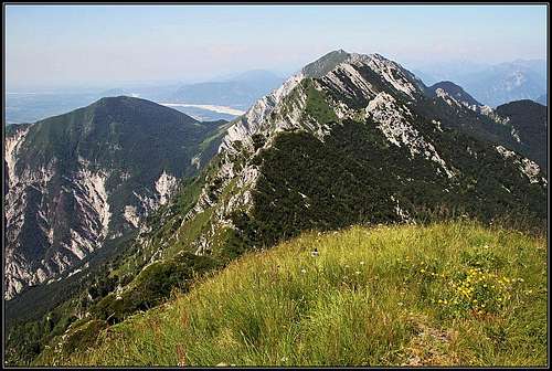 From Cueld i Lanis / Lanež towards the west
 The range from the S
 From the W
A lot about the range of Monte Chiampon / Veliki Karman, to which our mountain belongs, was already written on the pages of Monte Postoucicco / Postovčič, the easternmost high summit of the range and Monte Chiampon / Veliki Karman, the westernmost summit. Cuel di Lanis / Lanež is the third summit, counting from the east. Between Monte Postoucicco/Postovčič and it there is also a summit of almost equal altitude, called Monte Laschiplas / Laški plaz.
The southern slopes of all these mountains are high, very steep and rocky on top. The northern slopes are much lower, rocky only on top. From the summit of Cuel di Lanis / Lanež towards the north a side ridge goes, but it soon gets lost in forrests. The whole area is mostly abandoned, you will rarely meet there anybody. The summit of Cuel di Lanis / Lanež is easilly reachable, over its NE grassy slope the marked Alta via CAI Gemona comes. The route continues towards the west, but it is difficult and very rarely done. Browsing web pages and logs I havent met so far a description from anyone who would continue by this route. So, the majority of visitors only come from Tazaoro / Tam za goro alpine meadow directly on top, or they do a round tour by the main ridge over Monte Postoucicco/Postovčič. In times of mountain spring or in autumn the ascent on Cuel di Lanis / Lanež is very recommended. You will find there beautiful nature and the views around are very broad. See also the page of Monte Postoucicco/Postovčič!
Getting There
There is basically only one suitable trailhead for ascents on Cuel di Lanis / Lanež. From the sources of Torre/Ter river (restaurant) we can drive on towards the west by a narrow, a bit deteriorated, asphalt road. On the altitude of some 810 m a cart-road deters left, towards Casera Tacia/Tace (ex alpine meadow). There we can park (option No. 1). If we drive on some 500 meters, we can see inscriptions for the marked path No. 729, deterring left. There's the second option to park and start the tour. The last option is another 500 meters up the road, where on Plan di Tapou/Topol it is closed for public traffic. There is a big parking place. But continuing by the road (on foot) towards Tacia saddle, 1080 m, woud lead us much around, so better start on one of the two options below.
Coming on top from the southern side would be difficult. From the village of Cesariis/Podbrdo the passage over the mountain range goes quite towards the east. You can reach Dolina notch from there and then continue by the main ridge. For a return you would then descend on Tazaoro / Tam za goro meadow and need to go up on Dolina notch again. It was mentioned that west of Cuel di Lanis / Lanež there is a passage over the mountain range in the area of Siroke Dolegne / Široke doline. The route should start in the village of Pers/Breg, but nothing like it is drawn on the otherwise very good and detailed Tabacco map. Perhaps today only locals know where the passage goes.
And the third option, to come on Cuel di Lanis / Lanež from the west by Alta via CAI Gemona is also unsuitable. Not only because of a hard route, but also because of poor possibilities how to return to the car below Sella Foredor / Predol.
Routes Overview
| See full screen |
Normally I would create for each of the major routes a separate page, but the usual, direct approach is so simple that I will devote to it only a few sentences on this page. The ridge tour is described separately.  Tasaoro / Tam za goro meadow Tasaoro / Tam za goro meadow1. From Tasaoro / Tam za goro meadow. This is the normal and shortest ascent route. From one of the parking places on the mountain road below Plan di Tapou / Topol we go towards the W to the source of Vodizza/Vodičca, then southwards on Tazaoro / Tam za goro alpine meadow. Above the meadow, already in forrests, the path branches. The marked path No. 729 goes towards the SE on Dolina notch. Towards the right goes Alta via CAI Gemona, marked with red circles. It first continues by a shallow, forrested valley, then ascends over a gentle grassy slope on a broad pass north of Monte Laschiplas / Laški plaz, then crosses a nice, high grassy valley towards the W-SW. We clearly see the grassy pyramid of Cuel di Lanis / Lanež ahead of us. The path enters its steep slopes, aiming below a rocky crag in the northern ridge. After passing the crag we gain the N ridge and continue by it on top. 2 h 30 min from the road, easy, just steep grassy slopes. 
2. From Dolina notch over the E ridge. The ascent from the road to Tazaoro / Tam za goro meadow is identical as above, on the branching we go left and ascend in the SE direction Dolina notch. There we turn sharp right and go all the time by the main ridge. First we ascend Monte Postoucicco / Postovčič, then Monte Laschiplas / Laški plaz, finally Cuel di Lanis / Lanež. The route till Monte Postoucicco / Postovčič is described on a separate page, the continuation of the ridge route on another page (here). |
 haubi - on the ridge M. Chiampon - Cuel di Lanis
3. From Monte Chiampon / Veliki Karman. The route from the parking place below Sella Foredor / Predol to the summit of Monte Chiampon / Veliki Karman is described on the page of that mountain. The continuation of Alta via CAI Gemona is a bit unknown. In the Slovenian mountain guidebook it says only that the route is hard and partially very exposed. It is not protected, so on some places belaying is recommended. And it is also not a climbing route, because those steep grassy slopes really can not require any climbing skills. Map: Tabacco No. 027: Canin - Val Resia - Parco Naturale Prealpi Giulie. 1:25.000.
Red Tape
No special restrictions in the area.
Mountain Huts and Bivouacs
There are no official huts in this area. On Tazaoro / Tam za goro alpine meadow there are two huts standing, but they are closed. In emergency we might perhaps be able to overnight there.
When To Climb?
Do the tour on Cuel di Lanis / Lanež in dry seasons, from June to November. In winter the area must be completely abandoned. In the upper parts of the mountain in good conditions skiing might be very nice (from the summit down to Tazaoro / Tam za goro meadow), but the whole tour will be long, starting by the source of Torre/Ter, 540 m.
Your Help Needed
- Do you have any data about winter acsents?
- Do you know any more direct southern ascent(s)?