
|
|
Mountain/Rock |
|---|---|
|
|
38.52000°N / 119.79°W |
|
|
Hiking |
|
|
Spring, Summer, Fall, Winter |
|
|
9970 ft / 3039 m |
|
|
Overview
Tryon Peak is located south of Lake Tahoe, a short distance from Ebbetts Pass. Its proximity to Highway 4 allows for easy day hiking access. The peak provides fantastic views of the Ebbetts and Sonora Pass regions, Highland Lakes, and the Carson-Iceberg Wilderness. The great views from the summit can be had for minimal time and effort.The summit can be reached via easy class 1 terrain from Highway 4. The peak is a half day trip via the Pacific Crest Trail from this location. Noble Lake offers excellent backcountry campsites that can serve as a base camp for peak bagging in the area. Winter ski ascents are possible, but require starting from the Noble Creek Campground.
 Sunset on Tryon Peak
Getting There
The Ebbetts Pass Trailhead (38.549° N, 119.806° W) is located on the south side of Highway 4. Turn off the highway approximately 0.4 miles west of Ebbetts Pass and follow a short dirt road to the parking area. The road and parking lot will be muddy early in the season. From the parking area, follow a signed trail 0.2 miles south west to the Pacific Crest Trail. Follow the PCT south for approximately 4 miles. The summit is the south east high point.Red Tape
Tryon Peak lies in the Carson-Iceberg Wilderness. No permit is required for day hiking. A Wilderness Visitor's Permit is required for backcountry camping. Permits can be picked up at any of the following Stanislaus National Forest offices:Stanislaus National Forest
19777 Greenley Road
Sonora, CA 95370
(209) 532-3671
FAX (209) 533-1890
TDD (209) 533-0765
Calaveras Ranger District
P.O. Box 500
(Highway 4)
Hathaway Pines, CA 95233
(209) 795-1381
FAX (209) 795-6849
TDD (209) 795-2854
Groveland Ranger District
24545 Highway 120
Groveland, CA 95321
(209) 962-7825
FAX (209) 962-7412
TDD (209) 962-6406
Mi-Wok Ranger District
P.O. Box 100
(24695 Highway 108)
Mi-Wuk Village, CA 95346
(209) 586-3234
FAX (209) 586-0643
TDD (209) 586-0262
Summit Ranger District
#1 Pinecrest Lake Road
Pinecrest, CA 95364
(209) 965-3434
FAX (209) 965-3372
TDD (209) 965-0488
When to Climb
The peak is generally snow free from July through September. Highway 4 is not plowed in the winter. However, winter ascents are possible starting from the winter closure gate just below the Noble Creek Campground (7000'). Tryon Peak above Noble Lake
Camping
There are excellent backcountry campsites in the area around Noble Lake. In addition, there are several campgrounds in the Ebbetts Pass area:Silver Creek (38.589° N, 119.787° W): Located on the south side of Highway 4, approximately 6 miles east of Ebbetts Pass or 5 miles west of Markleeville.
Mosquito Lake (38.516° N, 119.915° W): Located on the north side of Highway 4, approximately 6 miles east of Lake Alpine.
Hermit Valley (38.539° N, 119.890° W): Located on the north side of Highway 4, approximately 9 miles east Lake Alpine.
Bloomfield (38.538° N, 119.825° W): Located on the west side of Forest Road 8N01, approximately 1.5 miles west of the Ebbetts Pass and 2 miles south of Highway 4.
Pacific Valley (38.518° N, 119.902° W): Located on the east side of Forest Road 8N12, approximately 8 miles east of Lake Alpine and 0.5 miles south of Highway 4.
Highland Lakes (38.489° N, 119.808° W): Located on the west side of Forest Road 8N01, approximately 1 mile west of Ebbetts Pass and 7.5 miles south of Highway 4.
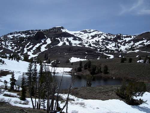 Tryon Peak above Noble Lake
Mountain Conditions
The Ebbetts Pass area is subject to a variety of weather conditions, including heavy snowfall in the winter. Weather forcast can be found HERE.The avalanche advisory can be found HERE.