
|
|
Mountain/Rock |
|---|---|
|
|
38.57958°N / 119.83766°W |
|
|
9679 ft / 2950 m |
|
|
Overview
Reynolds Peak is a prominent peak in the Mokelumne Wilderness which straddles the Pacific Crest between SR4 (Ebbetts Pass) and SR88 (Carson Pass). The 105,165 acre Wilderness takes in portions of the Toiyabe, Stanislaus, and El Dorado National Forests, and lies in the mid-Sierra region between Lake Tahoe to the north and the High Sierra to the south. The peak lies on the Sierra Crest, about three miles north of Ebbetts Pass, just west of the Pacific Crest Trail (PCT).
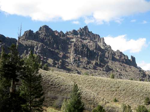
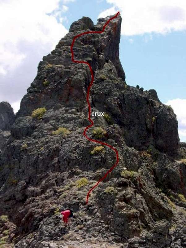
Its nearby neighbor Raymond Peak (two miles to the north) is higher and sees far more traffic than Reynolds Peak. Reynolds Peak looks nearly impossible from a distance, with its series of rocky pinnacles, and requires route-finding to reach the summit. As a result, Reynolds Peak only has three or four summit entries each year. However, Reynolds Peak is not only easier to reach than Raymond Peak, but the rock climbing is far more enjoyable and features a class 3 summit. The views from the summit go north to Freel Peak and Desolation Wilderness, west to Mokelumne Peak (and to the Coast Range on unusually clear days), south to the peaks of Emigrant Wilderness and northern Yosemite, and sweeping east into the Great Basin of Nevada.
Like most of the peaks in the Ebbetts Pass area, Reynolds Peak is composed of dark volcanic rock. Volcanic activity covered much of the region in layers of lava, ash, and mudflows. Over time, erosion and glacial activity removed much of the covering layers from all but the more prominent peaks and ridges. Reynolds Peak is the remains of one of these active composite volcanoes.
The resulting geology left some impressive peaks, most of which have poor rock-climbing qualities. Because of the poor adhesion in the metamorphosed rocks, protection is difficult and generally unsafe - as such there is little rock climbing in the region.
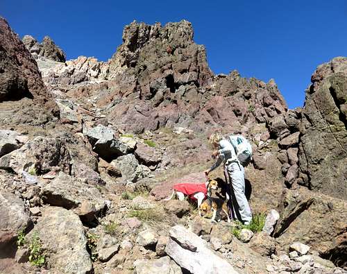
The summit can be approached from either the west or east sides, but due to its proximity to the PCT and Ebbetts Pass, it is almost always approached from the east. There are two prominent pinnacles at the top vying for the highpoint - the northwest one is the highest and where the summit register is located. It becomes fairly obvious as the highest point while on the mountain.
Thanks to Bob Burd for creating this page.
 |
 |
 |
Getting There
The easiest approach to Reynolds Peak is from Ebbetts Pass. Park at the PCT trail junction turnout on the north side of the road about a quarter mile east of Ebbetts Pass. Take the PCT for a little over 3 1/2 miles until you come to Raymond Meadows, half a mile due east of the peak. Reynolds Peak rises up high above the trail.
A shorter approach can be found by starting at The Elbow, a U-shaped turn in SR4 about 2.5 miles west of Ebbetts Pass. While the distance is only 2.5 miles, there is 800' more gain and the hike is all cross-country, with route-finding.
A third approach can be made from SR88 and Blue Lakes Road, but this is both more driving and more hiking than the other two, and should only be considered if you're already on SR88 and don't want to drive around to SR4. Pete Yamagata's extensive driving/hiking directions for Raymond Peak and further details on this route as it applies to Reynolds Peak can give you more information on this and the other approaches.
The summit itself appears daunting, but it is actually pretty standard Class III hiking. It is more fun than scary.
Red Tape
No permits or fees are required for day hikes in the Mokelumne Wilderness or for parking at the trailheads. A Wilderness Visitor's Permit is required for overnight visits to Mokelumne Wilderness. Only one permit is required for trips which are continuous and pass through more than one Wilderness. Group size is limited to 12 people for day use and 8 people for overnight use, with the exception of specially permitted groups traveling the Pacific Crest Trail.
When To Climb
Climbing is generally done June through October. Blue Lakes Road and SR4 are not plowed in the winter and close after the first significant snowfall, reopening around Memorial Day. Winter climbs are possible from the vicinity of Lake Alpine on SR4 where the road is plowed, but the distance is very long, and with potential for snow and ice, it is not advised to attempt a winter climb.
Camping
There are developed campgrounds on SR4, SR88, and along Blue Lakes Road. Fees range from free to $14.50/night. The USFS site lists all the amenities at each location along with contact information for reservations.
Backcountry camping is also allowed, following these restrictions:
Camp at least 100 feet from water and trails. Camping on previously used sites creates far less impact than camping on pristine sites. Camp on mineral soil, never in meadows or soft grassy areas that compact easily. Pick a place where you won't have to clear vegetation or level a tent site. Wilderness permits (see above) are required for camping within the Mokelumne Wilderness, and a fire permit (good for a year) is needed if you intend to have stoves or campfires anywhere within the National Forest.
For those interested in pack and saddle stock:
- Wolf Creek Pack Station
PO Box 1041
Verdi, NV 89439
916-345-0333 - Kirkwood Stables
PO Box 89
Kirkwood, CA 95646
209-258-7433
Mountain Conditions
Highway conditions can be found at Caltrans online by searching for Highway 4 or SR 88, or by phoning the California Department of Transportation road condition line at 1-800-427-7623.
Etymology
"Named in 1929 on the recommendation of the USGS for G. Elmer Reynolds, an advocate of forest conservation and for many years the managing editor of the Stockton Record. (BGN, Sixth Report, 640.)"
- Peter Browning, Place Names of the Sierra Nevada
External Links