
|
|
Mountain/Rock |
|---|---|
|
|
45.36600°N / 22.86200°E |
|
|
Hunedoara |
|
|
Hiking, Mountaineering, Trad Climbing, Skiing |
|
|
Spring, Summer, Fall, Winter |
|
|
7982 ft / 2433 m |
|
|
Overview
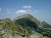
 Vârful Bucura -
  Bukura-csúcs
 The "twin peaks" of Vf. Bucura viewn from Custura Bucurei The "twin peaks" of Vf. Bucura viewn from Custura Bucurei |
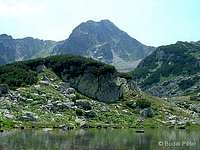
 Tău Porţii - summer Tău Porţii - summer |
|
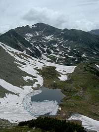 Tău Porţii - spring Tău Porţii - spring |
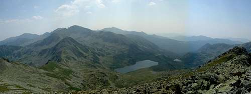 Southeast view from Bucura I: Bucura Lake and Vf. Peleaga
 Southwest view from Bucura I: Poarta Bucurei ridge and Vf. Judele
 North view from Bucura I: Vf. Retezat
Getting There
As Bucura peak is located in the northern region of Retezat, I would suggest approching it from Nucşoara village, through Pietrele valley. Getting to Nucşoara is described in detail on the Retezat Mountains parent page (follow instructions for North Retezat).
Alternatively, you might get a taxi to Poiana Pelegii campsite from Haţeg town, and stay there or hike up to Bucura Lake campsite. Bear in mind that the upper section of the road (from Rotunda hut) is often not passable for vehicles due to flood damage or fallen trees.
 Approach from Pietrele valley Approach from Pietrele valley |
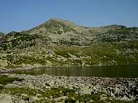 Viewed from Bucura Lake Viewed from Bucura Lake |
 On the main crest (red stripe) On the main crest (red stripe) |
Routes
Hiking
Hiking routes in Romania are marked by red, yellow and blue colors, and use three shapes: stripe, dot and triangle. From this point, I will use abbreviations for these (for example: YT=yellow triangle, RD=red dot, BS=blue stripe, and so on...)
Three marked trails lead to the main summit of Bucura:
- YS: coming from Vf. Retezat (2482 m) via Şaua Retezatului (saddle, 2251 m) and Şaua de iarnă (saddle, 2297 m), continuing towards Bucura Lake (2041 m) via Tău Porţii tarn (2230 m) - the peak is accessible by doing a short detour marked by RS
- RS: coming from Curmătura Bucurei (saddle, 2206 m), passing by - but not going up to - Vf. Bucura II
- RD: coming from Bucura Lake (2041 m) via Viorica, Florica and Tău Porţii tarns - the sign bifurcates after Florica tarn: the main path goes SW towards Şaua Judele and Zănoaga Lake, the other path goes N up to Tău Porţii, where it merges into YS (take this latter to Vf. Bucura)


Connections to huts and campsites:
- From Vf. Retezat YS leads to Pietrele hut (also campsite).
- From Şaua Retezatului BT leads to Pietrele hut.
- From Tău Porţii RD and YS both go to Bucura Lake campsite.
- From Curmătura Bucurei, BS leads to Genţiana and Pietrele huts (north direction) or Bucura Lake (south direction).
Connections to neighbour peaks:
 Vf. Retezat - YS Vf. Retezat - YS |
 Vf. Peleaga - RS Vf. Peleaga - RS |
 Vf. Judele - RD Vf. Judele - RD |
Circle trips:
Bucura peak can be combined with other prominent peaks in a dayhike, either from Pietrele/Genţiana huts, or Bucura Lake campsite:
- small circle
|a total of ~1250 m up, and the same down|
Pietrele hut (1480) - YS - Şaua Ciurila (1780) - YS - Vf. Lolaia Nord (2180) - YS - Vf. Lolaia Sud (2270) - YS - Şaua Lolaia (2215) - YS - Vf. Retezat (2482) - YS - Şaua Retezatuliui (2251) - YS - Şaua de iarnă (2297) - YS/RS - Vf. Bucura I (2433) - RS - Curmătura Bucurei (2206) - BS - Pietrele Lake (1990) - BS - Genţiana hut (1670) - BS - Pietrele hut - large circle
|a total of ~1660 m up, and the same down|
Pietrele hut (1480) - YS - Şaua Ciurila (1780) - YS - Vf. Lolaia Nord (2180) - YS - Vf. Lolaia Sud (2270) - YS - Şaua Lolaia (2215) - YS - Vf. Retezat (2482) - YS - Şaua Retezatuliui (2251) - YS - Şaua de iarnă (2297) - YS/RS - Vf. Bucura I (2433) - RS - Curmătura Bucurei (2206) - RS - Custura Bucurei (2370) - RS - Peleaga (2509) - RS/YC - Şaua Pelegii (2285) - RS - Lakes of Valea rea - YT - Pietrele hut /before getting there, RC departs for Genţiana hut/ - around Bucura Lake
|a total of ~700 m up, and the same down|
Bucura Lake (2041) - YC - Peleaga (2509) - RS - Custura Bucurei (2370) - RS - Curmătura Bucurei (2206) - RS - Bucura peak (2433) - YS - Tău Porţii (2230) - RD - Florica Lake - RD - Viorica Lake - RD - Ana Lake - RD - Bucura Lake
Climbing
|
Climbers will prefer the north-northeast wall of the lower summit, Bucura II.
The list of climbing routes on the right is adopted from this external source (you can also find hand-drawn sketches here). Difficulty ratings are according to the Russian grading system, which is used in Romania.
|
|
 The north face of Bucura II The north face of Bucura II |
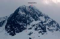 The north face of Bucura II The north face of Bucura IIin winter (photo: csaki) |
 The northeast face of Bucura II The northeast face of Bucura II |
Red Tape
 Preserve nature...
Vf. Bucura is inside the territory of Retezat National Park (further information about the park itself can be found on the Retezat Mountains parent page). It is forbidden to leave trails, camp outside of designated sites, or put up a fire. Swimming is prohibited in Bucura Lake (and the others as well, I suppose). If you plan to climb, it might be advisable to contact the National Park administration (see External Links section below) and/or Salvamont (Mountain Rescue, see Retezat Mountains parent page) in advance.
Beginnig from May 2010, a small admission fee of 5 RON shall be paid upon entry into the National Park. The ticket is valid for 7 days, independently of the number of entries within this period. The main NP visitor center is located by the road about halfway between Mălăieşti and Nucşoara villages.
You should bring all your trash back down with you when leaving (just like elsewhere)! Please do a favour for the mountains by fetching garbage that others have left behind (furtunately this does not happen very often, but if you look, you'll find).
Huts and Camping
The closest huts are Cabana Genţiana (1670 m) and Cabana Pietrele (1480 m). The latter consists only of scattered bungalows and a designated campsite now, since the old hut burned down in February, 2007. From these huts Vf. Bucura is accessible via the Lolaia ridge (YS, through Vf. Retezat), by Stânişoara valley (BT to Şaua Retezatului, then turn left - south - on YS) and by Pietrele valley (BS until Curmătura Bucurei saddle, and then turn right - west - on RS).
The nearest campsite is at Bucura Lake (2041 m), offering three easy alternatives to reach Vf. Bucura: RS, YS, and RD-YS (each of these can be accessed by walking more or less on BS towards Curmătura Bucurei). Zănoaga Lake (2000 m) and Poiana Pelegii (1600 m) campsites are not too far, either. From Zănoaga Lake RD leads to Şaua Judele (there's a tempting side-track towards Vf. Judele) and further to Lacul Agătat tarn (after that, take the bifurcation of the trail up north towards Tău Porţii, which is just below Vf. Bucura). From Poiana Pelegii you'll have to take the BS/RC combo to get to Bucura Lake first, then continue as described above.
More information about these campsites and huts can be found on the Retezat Mountains parent page.
When to Climb
 Winter climb Winter climb(photo: dikla) |
The most welcoming weather can be anticipated around late summer - early fall, when precipitation is relatively little, but temperatures are still warm. Though it is possible to ascend the peak in the winter, you have to be an experienced mountaineer to do it safely, since there is limited mountain rescue service in this time of the year (see Retezat Mountains parent page) and the chances of avalanches is generally high in the area. It is safer to go if you have already been there in the summer, and know the terrain. |
 Winter summit view Winter summit view(photo: dikla) |
Weather
Below you can find a weather forecast for Bucura lake (located nearby, just SE from the mountain, on 2014 m) by viewweather.com:
Maps
Paper maps
See the Retezat Mountains parent page.
Online maps
A powerful free online map is being developed by the Open Maps Project for the area of Central Europe. If you are not familiar with the area or want to skip the zooming job, you can get a quick close-up view of Bucura's area by following this permalink.
Miscellaneous
For some useful travel information about Romania, check out this page.
External Links
Retezat National Park official homepage
Retezat on PAN Parks page: short introduction
Retezat page on alpinet.org: only in Romanian, but has up-to-date news section, maps (SRTM map, topo map) and huts info