
|
|
Mountain/Rock |
|---|---|
|
|
45.37000°N / 22.90800°E |
|
|
Hunedoara |
|
|
Hiking, Mountaineering, Skiing |
|
|
Spring, Summer, Fall, Winter |
|
|
8228 ft / 2508 m |
|
|
Overview
 Vârful Păpuşa -
  Papusa-csúcs
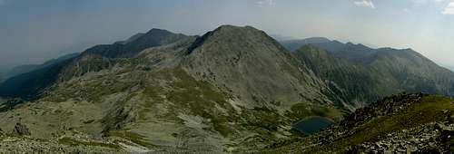
 East view of Păpuşa East view of Păpuşa |
|
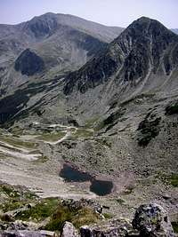 Lake Adânc. Lake Adânc. |
 West view from Păpuşa.
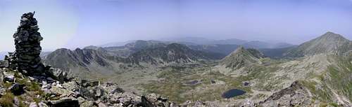 Northwest view from Păpuşa.
Getting There
Păpuşa peak is located in the northern region of Retezat, so I would suggest approching it from Nucşoara village. Getting to Nucşoara is described in detail on the Retezat Mountains parent page (follow instructions for North Retezat).
Alternatively, you might get a taxi to Poiana Pelegii campsite from Haţeg town, and stay there or hike up to Bucura Lake campsite. Bear in mind that the upper section of the road (from Rotunda hut) is often not passable for vehicles due to flood damage or fallen trees.
Another, less common approach is from Hobiţa /Hobica/ village. From Hobiţa, the lengthy blue triangle leads to Şaua Custurii (saddle, 2205 m, near Păpuşa peak, see Routes section), via Baleia hut (1410 m, recently reported to be reopened, also campsite), Şaua Gorova (saddle, 1816 m, campsite nearby) and Stâna din Râu (1600 m, campsite). Hobiţa can be reached by car from Pui /Puj/ village, which is located on national road 66 (European E79, connecting Haţeg /Hátszeg/ with Petrosani /Petrozsény/).
Routes
Hiking
Hiking routes in Romania are marked by red, yellow and blue colors, and use three shapes: stripe, dot and triangle. From this point, I will use abbreviations for these (for example: YT=yellow triangle, RD=red dot, BS=blue stripe, and so on...)
Păpuşa can be accessed on two marked tourist trails running on its three ridges (described from west to east, but of course they can be walked the other way as well):
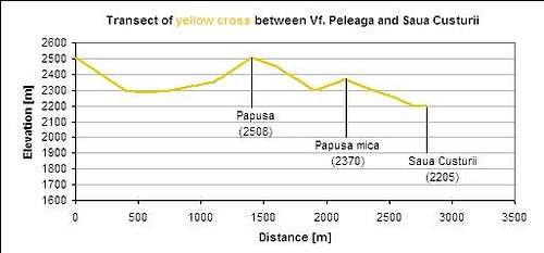
- YC: coming from Vf. Peleaga (2509 m) towards Şaua Custurii (Custura saddle, 2205 m) and further towards Vf. Custura peak
- RS: coming from Şaua Vf. Mare (saddle towards the east, 2345 m), via Porţile Închise (a more exposed ridge section)

Connections to huts and campsites:
- From Şaua Pelegii (Peleaga saddle, 2285 m, between Vf. Peleaga and Vf. Păpuşa) there are marked paths leading north towards Cabana Pietrele (RS, then YT) and Genţiana (RS, YT and RC).
- From Şaua Vf. Mare there are marked path to Pietrele hut (RT, with possibility to switch to RS and go to Genţiana hut via YT - RC) and the remote Baleia hut (RS/RT parallel, passing through Gorova saddle campsite).
- From Şaua Custurii, the BT leads down to Stâna din Râu campsite (~2 km, ~600 m drop), while YC continues until Vf. Custura (where you can take RS to Şaua Plaiul Mic saddle and eventually to Buta hut or Poiana Pelegii campsite on the RC/BS combo).
Connections to neighbour peaks:
 Vf. Peleaga - YC Vf. Peleaga - YC |
 Vf. Custura - YC Vf. Custura - YC |
 Vf. Mare - RS Vf. Mare - RS |
Circle trips:
Since Peleaga and Păpuşa are neighbors, they can be combined in one dayhike from either Bucura Lake, or the northern huts: Pietrele and Genţiana. If you are coming from the huts, it is possible to make good circle-trips:
- small circle
|a total of ~1100/1300 m (Gentiana hut/Pietrele hut) up, and the same down|
Pietrele hut (1480) - BS - Genţiana (1670) - BS - Curmătura Bucurei (2206) - RS - Custura Bucurei (2370) - RS - Vf. Peleaga (2509) - RS - Şaua Pelegii (2285) - YC - Vf. Păpuşa (2508) - YC - Şaua Pelegii (2285) - RS - Valea rea (valley) - YT - Pietrele hut /before getting there, RC departs for Genţiana hut/ - large circle
|a total of ~1300/1400 m (Pietrele hut/Gentiana hut) up, and the same down|
Pietrele hut (1480) - BS - Genţiana (1670) - BS - Curmătura Bucurei (2206) - RS - Custura Bucurei (2370) - RS - Vf. Peleaga (2509) - RS - Şaua Pelegii (2285) - YC - Vf. Păpuşa (2508) - RS - Porţile Închise (ridge) - RS - Şaua Vf. Mare (2345) - RT - Galeş Lake (1990) - for Pietrele hut: RT via Galeş valley; for Genţiana hut: RS-YT-RC via Şaua Zănoagelor (2270) and Valea Rea valley
There is another appealing circle-trip, if you are based at Poiana Pelegii, or at Bucura Lake campsites:
- "three peaks circle"
|~1400 m up and the same down|
Poiana Pelegii (1600) - RC/BS - Bucura Lake (2041) - YC - Vf. Peleaga (2509) - YC - Şaua Pelegii (2285) - YC - Vf. Păpuşa (2508)- YC - Şaua Custurii (2205) - YC - Vf. Custura (2457) - RS - Şaua Plaiul Mic (1879) - RC/BS - Poiana Pelegii
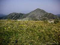
 Păpuşa viewn from Peleaga.
Climbing
There are no reported climbing routes on Păpuşa. Its north face seems to offer some possibilities, though.
 North face
Red Tape
 Preserve nature...
Vf. Păpuşa is inside the territory of Retezat National Park (further information about the park itself can be found on the Retezat Mountains parent page). It is forbidden to leave trails, camp outside of designated sites, put up a fire, or swim in the lakes.
You should bring all your trash back down with you when leaving (just like elsewhere)! Please do a favour for the mountains by fetching garbage that others have left behind (furtunately this does not happen very often, but if you look, you'll find).
Beginnig from May 2010, a small admission fee of 5 RON shall be paid upon entry into the National Park. The ticket is valid for 7 days, independently of the number of entries within this period. The main NP visitor center is located by the road about halfway between Mălăieşti and Nucşoara villages.
Huts and Camping
The nearest huts towards the north are Cabana Genţiana (1670 m) and Cabana Pietrele (1480 m). The latter consists only of scattered bungalows and a designated campsite now, since the old hut burned down in February, 2007. Păpuşa peak is accessible from either of these huts via three saddles: Curmătura Bucurei, Şaua Pelegii and Şaua Vf. Mare saddles (see Routes section above for descriptions). The closest hut towards the south is Cabana Buta (1580 m), from which Păpuşa peak is accessible via Custura peak.
The nearest campsites are Bucura Lake (2041 m, YC leads to Păpuşa peak through Peleaga peak) and Stâna din Râu (1650 m, BT to Şaua Custurii and then YC to Păpuşa peak). Stâna din Râu is quite away from most of the other peaks, though. From Poiana Pelegii campsite (1600 m) you have to take a detour either towards the northwest (Bucura Lake - Peleaga peak) or the southeast (Custura peak). This, however, offers the possibility to make a one-day circle-trip, summiting three of the highest peaks of Retezat (as described in the Routes section above).
More information about these campsites and huts can be found on the Retezat Mountains parent page.
When to Climb
 in autumn colors
The most welcoming weather can be anticipated around late summer - early fall, when precipitation is relatively little, but temperatures are still warm. Though it is not impossible to ascend the peak in the winter, you have to be an experienced mountaineer to do it safely, as the chances of avalanches is generally high in the area.
There is no mountain rescue service outside the summer season (see Retezat Mountains parent page), so - unless you are an experienced winter mountaineer - it's safer to go if you have already been there in the summer and know the terrain.
Weather
Below you can find a weather forecast for Peleaga peak (the western neighbour of Păpuşa) by viewweather.com:
Maps
Paper maps
See the Retezat Mountains parent page.
Online maps
A powerful free online map is being developed by the Open Maps Project for the area of Central Europe. If you are not familiar with the area or want to skip the zooming job, you can get a quick close-up view of Păpuşa's area by following this permalink.
Miscellaneous
For some useful travel information about Romania, check out this page.
External Links
Retezat National Park official homepage
Retezat on PAN Parks page: short introduction
Retezat page on alpinet.org: only in Romanian, but has up-to-date news section, maps (SRTM map, topo map) and huts info