
-
 9051 Hits
-
 77.47% Score
-
 8 Votes
|
|
Mountain/Rock |
|---|---|
|
|
42.84123°N / 0.78861°W |
|
|
Hiking, Mountaineering, Trad Climbing, Big Wall, Scrambling, Skiing |
|
|
Spring, Summer, Fall, Winter |
|
|
6886 ft / 2099 m |
|
|
Overview
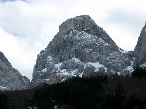
The Achar de Alano is an impressive tower over the Tatxeras plains, from where it looks an inaccessible peak without climbing, but the reallity is different thanks to Tatxeras passage, that permit acces without complications (30 degrees in winter) to the south face, along which the normal route goes .
To reach the summit of Achar de Alano is only necessary (by the normal route, south face) a little scrambling (about 5 meters) of I degree.
Outside the south face all the Achar de Alano routes are very complicates and requires climbing.
Alanos range

Closing by the south the ridge that begins in Auñamendi (2507m) the Alanos range (sierra de los Alanos) is an important mountain alignment. Over Zuriza valley the Alanos range looks like an inaccessible wall that is impossible to go through.
Really the wall of Alanos range is possible to go through thanks to two principal passages:
Canaletas de Ruzkia
(Ruzkia canals) Between Ruzkia (2074m) and Ralla de Alano, 35 degrees in winter
Paso de Tatxeras
(Tatxeras passage) Between Achar de Alano (2099m) and Agujas de Alano, 30 degrees in winter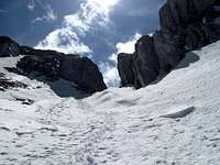
Getting There
The normal route to reach the summit of Achar de Alano begins in a parking near Zuriza called Tatxeras (1270m)From Pamplona:
You have to go by the road N-240 60 kilometresmore or less (some of them flanking Yesa swam) to a place with a petrol station where the road to Sigues begins. Follow that road (NA-137) 30 kilometres more or lest crossing small villages to the most important village of Roncal valley, Isaba (814m) From Isaba follow 3 kilometres to the north (by the road that ascents to Puerto de Belagua) and turn right on the crossing marked as Zuriza/Ansó This road (NA-2000) will take you across the valley of Belabarce and then ascents to Puerto de Argibiela (1290m)
Then the road descents some meters to Zuriza. Continue some meters by the road that takes you to Linza hut to a crossing to the right marked as Tatxeras. Take that crossing and follow the road 3 kilometres to Tatxeras parking.
 Tatxeras parking
Red Tape
No permits requiered
 |
 |
 |
Places to sleep
At 3 km of Tatxeras parking, in Zuriza there is a camping. In the valley of Belagua another one.At 8 km is Linza hut
When to climb
Is possible to climb all the year, but in winter after bigs snowfalls there is avalanche risk, principally in Paso de Tacheras.In winter don't forget crampons and piolet.
The ascent by Canaletas de Ruzkia with ice is a little delicated.

Weather and mountain conditions
Weather in IsabaMountain conditions in Pirineo Navarro
(in spanish)
External Links
Achar de Alano by Mendikat (in spanish)
Rafa Bartolome - Apr 17, 2009 5:11 am - Voted 10/10
coordenadas cima42.84123 -0.78861
RicardoEchanove1 - Apr 17, 2009 5:26 am - Hasn't voted
Re: coordenadas cimaGracias Rafa, las pongo ahora mismo