
|
|
Mountain/Rock |
|---|---|
|
|
44.76330°N / 111.3906°W |
|
|
Madison |
|
|
Summer, Fall |
|
|
10606 ft / 3233 m |
|
|
Overview
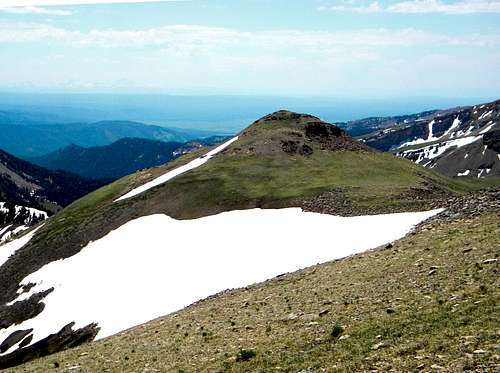
 Sheep Point is the highest mountain in the Henrys Lake Mountains
 The summit
 From the south
 South ridge end
Sheep Point is the unofficial name of the high point of the Henry’s Lake Mountains, a small local range on the Continental Divide between Idaho and Montana just west of Yellowstone National Park. The summit itself is not on the divide, but on a spur ridge that runs north into Montana. A lower point a few miles away gets the name Sheep Mountain. Sheep Hill is the northern end of the high alpine area that runs for several miles in the south-central core of the mountains and while most of the mountain is gently sloped, the north face forms a dramatic 1,535 foot face that falls into Sheep Lake, one of the largest lakes in the mountain group. This high point is 10,606 feet high with an impressive 3,676 feet of prominence.
The mountain is formed by a broad, 3/4 mile long ridge with a small summit cap on the north end. On the east side, the slopes drop off steeply into the Coffin Basin, but the west side offers an interesting bench area of rolling terrain pocked with small ponds and springs. The south end terminates at a point (10,250 ft.) on the Idaho border that falls off into the large Targhee Creek headwaters basin that has eight lakes and extensive meadow systems. The entire area is a spectacular subalpine/alpine setting with enough gentle ground to require several days to adequately explore. The summit mass connects to the nearby Fremont County, Idaho highpoint by an open 9,760 saddle separating the lake area in Idaho from the rolling pond and spring filled landscape on the west flank of Sheep Hills. The mountain rises 1,600 feet above the lake basin to the south and 2,200 feet above the Coffin Lakes to the east. The mountain rises 3,800 feet above the valley bottom three miles to the west. The terrain to the north in Montana is more of a deep drainage network than the rolling highlands and broad ridges in the other directions.
This mountain can be done in a long day hike by a strong hiker up the main fork of Targhee Creek to the lake basin and up the south flank and onto the north running ridge. About one third of the distance would be cross country, but the landscape is open and easily traversed. Overall the grade would be fairly gentle except for hiking up the south end. From the Targhee Creek trailhead it is about an eighteen mile round trip to the summit and back. It’s also about a fifteen mile round trip from the north up Sheep Creek to Sheep Lake. The climb above Sheep Lake would be a very difficult scramble or technical climb on poor rock to the summit. It might be best to camp or make it an extended hike and spend some time on the other summits or several lakes found in this small, but interesting mountain group. Mountain goats can be seen in these areas and they have left many small trails in the scree and talus. This is a grizzly bear area so take pepper spray, make noise, have a clean camp and take some friends who you can outrun.
 The south point of the long summit ridge
Getting There
 The Targhee Basin is probably the easiest way to reach Sheep Point
 Ascending the ridge
 On the main ridge
 Nearing the summit
 In Targhee Basin
 Sheep Creek Basin
The area can be entered via the Mile Creek Trail (004) or the Sheep Creek Trail from the Montana side or from the Targhee Creek Trail (27) on the Idaho side. The Targhee National Forest does a great job of providing access and trail info from the Idaho side on the internet, but the Beaverhead NF does a terrible job for the Montana side. Details for the Mile Creek Trail on the Montana side are provided here.
Mile Creek Trail
If coming on Highway 20 from the south, drive 42 miles north from Ashton to the junction with Highway 87. Turn left (west) on Highway 87 drive nine miles to the Idaho/Montana State line and continue north on the same road for approximately 3.6 more miles to the Mile Creek Road. This is marked by a small roadside sign that looks like its pointing into the driveway of a large house close to the highway. Take it and the road will almost immediately turn away from the house and head for the mountains. From the turnoff from Highway 87, its one mile to the trailhead. There is a stream to cross immediately before the trailhead, but the bottom is a hardened crossing so it should be no problem for most vehicles. If unsure there is room to park west of the creek and cross on foot. The total distance from Highway 20 to the trailhead is almost 14 miles.
To reach the trailhead from the north take Highway 287 south from Ennis, Montana for 40 miles, then turn right (south) on Highway 87 and go five miles south to the Mile Creek turnoff by the large house mentioned above. If coming from the east, go 13 miles from West Yellowstone over Targhee Pass to the junction of Highway 20 mentioned above. Follow the directions from there.
The Mile Creek Trail is not as indicated on USGS quad maps. The first two or three miles is the same, but new construction takes the trail on a series of long switchbacks and reaches the top of the Continental Divide further south than indicated on the quad maps. The trail is obvious and there is no way to get lost on the old trail. From the trailhead follow the path south up the Mile Creek basin for approximately six miles to the junction with the Targhee Creek Trail (27) on the Continental divide separating the Targhee Creek and Mile Creek basins. From here make a left turn go approximately two miles to Targhee Pass. From Targhee Pass follow the main divide to the northwest across the Fremont County highpoint for about two and a half miles to the south end of Sheep Hill or continue on the trail for nearly two miles to near Clark Lake. From there enter the upper lake basin that connects to the south end of the Sheep Hill ridge.
Targhee Creek Trail
To reach the Targhee Creek Trailhead go 15 miles north of the Island Park Ranger Station on Highway 20 to Forest Road 57 and follow it a short distance where it ends at the trailhead. The turnoff for road 57 is about 10 miles west of West Yellowstone. From the trailhead hike north up the main fork of Targhee Creek for about six miles to the vicinity of Clark Lake, then head northwest cross country into the upper lake basin. The steep south terminus of the Sheep Hill ridge is nearly two miles away on the north end of the basin. Or one can head more northwest and hit the saddle between Sheep Hill and the Fremont County highpoint, then turn north for a more gradual ascent up the west side of Sheep Point.
Sheep Creek Trail
The Sheep Creek Trail enters the mountains near the west end of Earthquake Lake and travels east, then south for about six or seven miles to Sheep Lake. From Sheep Lake it would be a challenging scramble or technical climb on poor rock up the cirque to the summit of Sheep Hill. Specific details are not provided here so study a local map or contact the Beaverhead National Forest offices provided below for information on this route.
Red Tape
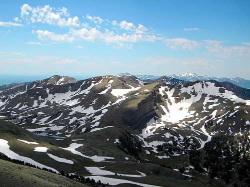
 Sheep Mt from Sheep Pt
Generally none. The area is not designated wilderness, though it is largely managed as such. In the core travel areas travel is limited to hikers and horses. Other areas allow bikes, but all areas are non-motorized. The Targhee National Forest provides an excellent travel planning map online for access from the Idaho side. It is assumed management for the Montana side is similar, but that information is not as readily available. If it matters use the Beaverhead-Deer Lodge contact information provided below.
Camping
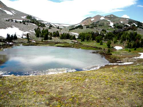 Sheep Hill and the upper Targhee Basin where camping opportunities abound.
 Sheep Lake from the summit
 Little Coffin Lake is east of the south point
All camping options in the vicinity of this mountain require one to pack in unless attempting a very long day hike. There are extensive camping opportunities very close to the mountain at Sheep Lake, the high pond/spring filled bench along the upper west side of the mountain, or in the basin at the head of Targhee Creek, which is adjacent the south end of the mountain. All of these require a fairly long pack in, but the terrain is mostly gentle and year long water can be found. For those on extended hikes in the Henry’s Lake Mountains good camping can be had at Targhee Pass, the flats at the northeast basin of Black Mountain or the Coffin Lakes. Water availability at these locations may vary so plan ahead.
 The interesting flats at the west foot of the summit ridge
When To Climb
The snow is still heavy well into June most years, but by the start of July enough of the trails and slopes are open to provide good access. The north slopes may hold their snow well into summer however. The south aspects lose snow quite early in the summer, but getting to the mountain would be difficult due to snow on the forested sections of the approach. The mountain can be reached in winter by the hard core, but some slopes would be prone to avalanches and access would be long, difficult and dangerous.Mountain Conditions and Information
 The ridge south
 The west flats
Go to the mountain prepared for variable conditions. A summer a day that starts out nice and clear often will see thunderstorms move into the mountains bringing rain, cold and lightning. Check the forecast closely and be prepared.
The mountain is entirely on the Beaverhead National Forest, but some of the main approach options are entirely or partially from the Targhee National Forest in Idaho, thus the following contacts are given:
For specific information contact the Island Park Ranger District of the Targhee National Forest. An access map on this Forest’s web page makes planning easy.
Island Park Ranger District
Targhee National Forest
3726 Highway 20
Island Park, Idaho 83429
(208) 558-7301
For the Montana side this area is part of the Madison Ranger District of the Beaverhead-Deer Lodge National Forest.
Madison Ranger Station
5 Forest Service Road
Ennis, MT 59729
Phone: (406) 682-4253
NOAA Forecast
 A nice view to the south from the summit of Sheep Point