
-
 27886 Hits
-
 85.36% Score
-
 20 Votes
|
|
Mountain/Rock |
|---|---|
|
|
43.16300°N / 109.6263°W |
|
|
13722 ft / 4182 m |
|
|
Overview
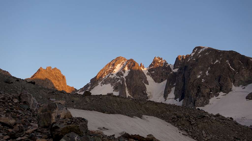
Mount Warren is located in the northern Wind River Range of Wyoming. Wyoming's fourth highest peak is not nearly as famous as the three highest. Each summer, any of those three is likely climbed more than Warren has ever been climbed; it has seen only dozens of ascents, although this will likely change very soon and start to become more popular. A true mountaineer's peak, it sits at the heads of the valleys of Dinwoody (Dinwoody Glacier), the trailless Bull Lake Creek North Fork (Helen Glacier) and Titcomb Basin. The Warren massif stretches from Bonney Pass to the base of the east face at Elsie Col, and includes the sub-summits of Les Dames Anglaises, Doublet, and Dinwoody. The highpoint is the easternmost summit of the massif (which meets the Continental Divide at the Doublet pinnacles). Though the Wind River's two highest peaks have had standard routes evolve (the SW buttress on Fremont, the Gooseneck on Gannett) and the Grand Teton has two (Exum, Owen-Spalding), no standard route has evolved on Warren, however a class 3 route has been used and is the route described in the route section below. Historically, routes have been used on all sides of Warren and on various features. Crevasse hazards on Dinwoody and Helen Glaciers are more prevalent around Warren than they are for the standard route on Gannett, and bergschrunds on either side of the mountain pose an obstacle for all routes except the west ridge from Bonney Pass (II, 5.2).
Though vagueness of route descriptions (somewhat a tradition) and location continue to make this high peak a reclusive testpiece, most routes go at class 4/easy 5-mixed and Grade II (unless basecamp is set higher, on a glacier). Like many of the highest peaks in the range, the top few hundred feet is a gentler, pre-erosional cap of looser material. The rest of the peak is gneiss and, most of the year, ice/snow covered. The routes are somewhat loose by Wind River standards and climb best as mixed routes. 32 Wyoming 13ers can be seen from the summit on a clear day.
Getting There
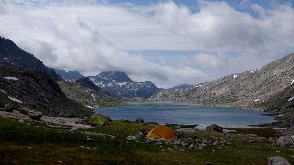
Use the Elkhart Park Trailhead accessed from Pinedale on the west side of the range and hike the Pole Creek Trail to Island Lake, passing by Photographers Point and Seneca Lake along the way. Just after passing over a small divide at 10,660 feet Island Lake will come into view. Descend to it and continue to the junction with the Titcomb and Indian Basin trails. Take the Titcomb Basin Trail heading north/leftward and hike past Lower and Upper Titcomb Lakes as the trail follows along their east shores. Base camp can be set up about 0.5 mile past the upper lake where many rock shelters have been built by Gannett Peak climbers and other backpackers. This is going to be the shortest and most commonly used approach for anyone climbing Mount Warren, however it's important to note you will not be able to see Warren until you are right at its base.
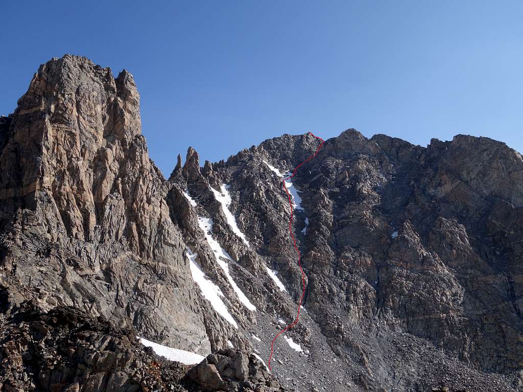
Easiest Route - Southwest Chute Class 3
This route is not included in the Kelsey guidebook, but was the route I used to climb the peak after climbing nearby Spearhead Pinnacle, another one of the Wyoming 13ers.
Approach from Titcomb Basin and continue north up the valley as if you were heading to Bonney Pass. You will pass below and around the very steep west face of the towers on Mount Helen, then pass below the base of the prominent NE couloir that shoots straight up to the upper north face of Helen. Shortly after passing the base of this inspiring couloir, you will see another couloir/gully that heads up to the low 12580 foot saddle bwtween Helen and Forked Tounge. This is the next gully north of the steeper NE couloir. Ascend this, which starts as a gentle open slope, but narrows into a 35-40 degree couloir (which will be snow covered on the lower 2/3 most of the summer) until you reach the saddle. The views to the east are particulairly nice at sunrise.
At the saddle, drop 150 feet or so to the east side and cut north, traversing the snow around the east side of Spearhead Pinnacle and continue in a northerly direction towards a series of gullies on the south face of Warren. The gully you want is the one furthest to the right (but not the one waaaay off to the right that ends well east of the summit), facing due south that continues almost directly to the summit. Ascend slightly steepending snow or talus up the lower south slopes to the 12900 foot level, then cross below the base of three other SE facing snow gullies each of which leading up towards Doublet Peak and other towers on the lower west ridge of Warren. The gully furthest to the right (east) curves leftward higher up and terminates on the upper west ridge of Warren above all the towers and gendarmes between Doublet and Warren. Begin ascending this gully.
The lower part of this gully begins with some class 3 scrambling on fairly solid rock for about 100 feet next to a small meltwater stream, then turns to loose scree and talus. Staying on the left side of the gully proper provides more solid class 3 rock, and eventually you can scramble up alongside the edge of the narrow band of steep snow remaining in the gully. Depending on the time of year there may be more or less snow in this chute, but it can be climbed in early season as a 40-45 degree snow route. At 13460 feet, where the gully begins to curve left, cut to the right and cross to the east side of the snow band if scrambling on the left side. Crampons are a good idea even though it's pretty narrow, as it is slightly over 40 degrees. You're aiming for the slightly hidden gully/ledge system that veers to the right which terminates right next to the summit. This is much easier than continuing up the main chute where the snow steepens to 50 degrees and reaches the west ridge further down from the summit.
Scramble up through a class 3 gully which is hidden from the base of the route, but provides easy access to a lower angle slope leading to the crest of the east ridge only 20 feet below the summit. Walk another minute on the ridge to the top. I'm pretty confident this is the easiest route on Warren as we encountered no class 4 on this route. Overall it was not as loose as expected, so if anyone is looking for a new standard route on Warren this is probably it.
Other more common routes on Warren are outlined below. There are a plethora of steep early season snow routes and probably a fair amount of late season ice/mixed routes that can be done on the wild north face of this complex mountain for climbers looking for a more difficult challenge.
| Route Name | Brief Description |
| East Ridge from Elsie Col | The lower cliffs can be bypassed on the south side of the crest via a Class 4 chimney, the rest of the upper ridge going at Class 3. |
| West Ridge from Bonney Pass | Reported to go a Class 5.2, however there will be many large gendarmes and towers to traverse over/around with loose rock, including Dinwoody and Doublet Peaks. |
| Northeast Face from Elsie Col | Instead of rounding the lower cliffs of the east ridge by cutting to the south, you can cut to the north and climb a steep snow/ice ramp (AKA Halls Ramp) that leads to a wide snow slope above meeting the east ridge close to where the SW chute route does. |
Regulations and Specifics
The west side is managed by the Bridger Wilderness and National Forest. The east side is managed by the Fitzpatrick Wilderness of Shoshone National Forest. Wilderness regulations apply for camp locations, group size, campfire restrictions and ethics. There are no permit requirements in these two wildernesses. Minimum-impact camping and travel ethics are increasingly important at Double Lakes cirque, Seneca Lakes and in Titcomb Basin. Backpacking stoves are necessary and water filtration is suggested. A fee-based campground exists at the Elkhart Park trailhead. There is undeveloped camping at the Torrey (Trail Lake) trailhead.
Season & Conditions
Summer season in the Wind Rivers is generally July-September with snow lingering on the higher trails into July. A snow storm is traditional between the last week of August and the second week of September. This is normally followed by a dry period with crisp temperatures for 1-4 weeks. Crevasses are hidden in June and begin opening sometime in July. Because the Trail Lake/Torrey trailhead is below 8000' on the dry side of the range (the glaciers above absorb the majority of the storms), the trailhead can surprisingly be reached almost year round, the exception being during heavy spring storms. The downside for ski approaches is that several miles must often be hiked before snow is reached. The road to Elkhart Park (the only paved road in the range) is plowed to within 2.5 miles of its end in the winter - about 2 miles past the turnoff to White Pine. The approach is heavy with mosquitos June thru August. Water must be carried the first 10 miles of the Glacier Trail.
An area webcam depicts current conditions.
Map
This map shows the SW Chute route described above with a blue line from a typical camp in Titcomb Basin. Combining with the north ridge of Spearhead Pinnacle is also displayed.
History & Etymology
Serious attention and juxtapositional assessment was first given to the peak by Arthur Tate on his second reconaissance expedition to Gannett in 1920. He named it Mount Elsie (for Riverton resident Elsie Stahlnaker, his packer's wife) after reaching Elsie Col.
In 1924, famous Colorado Mountain Club members Albert Ellingwood and Carl Blaurock were the third attempt party and the first to reach the summit, renaming the peak "Mount Harding". (They reached Elsie Col belatedly at 3:20p but still summited - at 4:10p!).
As with the Southern Rockies peaks Evans and Elbert, in neighboring Colorado, the peak was eventually and officially renamed for an early governor. Francis E. Warren was the governor when Wyoming territory became a state.
In 1929, Robert Underhill, Henry Hall (fresh from the first ascent of Logan) and Kenneth Henderson traversed all of the summits (and preferring the name "Broad Peak be bestowed)". They named the pinnacles west of the summit Les Dames Anglaises after a group of similar looking gendarmes they had encountered on the Peuterey Ridge of Mont Blanc. Doublet was the name they gave to the twin-pinnacled western summit at the divide junction. In 1930, Henderson simply called the peak "Peak 2".
The pinnacle labeled "Dinwoody Peak" on the current USGS topo (it's actually one of the western pinnacles of the massif) is the easiest of the massif highpoints to reach and was first gained in 1922 by a recon party that had been unsuccessful in attaining Warren from the east in previous days (they made it no further than this point). It's a scramble from Bonney Pass and was named after Dinwoody Pass. Climbers now continue to the true summit via a short rappel. Because there is an "official" Dinwoody Peak further down the Dinwoody valley, and because Dinwoody Pass has been offically renamed Bonney Pass, this summit of the Warren massif is now called Bonney Point by many climbers. "Dinwoody" itself is a corruption derived from 'Lt. William Dinwiddie'; a cavalryman and explorer who was stationed at nearby Fort Washakie in the 19th century and was fond of fishing the Dinwoody Lakes in the foothills below.
Bonney Pass is named for Wyoming mountaineer, guidebook author, historian and AAC vice president Orrin Bonney who pioneered its usefulness as an approach to Gannett and neighboring peaks from Titcomb Basin in the 1930s. Though still mislabeled as Dinwoody Pass on some later maps, the name changes for the features to "Bonney" became official in 1991.
Because the lowest notch between Warren and The Sphinx is west of Bonney Pass, the massif shoulder can also be said to include the sub-summit of Miriam Point (a walkup of a couple hundred feet next to the pass) and Bob's Towers (all of which are technical). Robert Underhill traversed all the summits from Elsie Col to Skyline Col, naming Miriam after his wife. Bob's Towers, the westernmost of these summits carries his name.
Titcomb is named after local brothers and route pioneers Charles and Harold Titcomb who, in 1901, were only the third party to see Wyoming's popular, hidden valley of thirteeners.
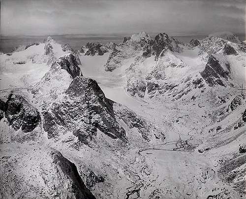
Fly-by shot of east sides of: Helen, Warren (center) and Gannett. Helen Glacier descends from Spearhead-Forked Tongue. Turret Peak is just right of Warren and Gannett appears above/behind Sunbeam Peak. (Post, Austin S.; 1960. Helen Glacier. From the Glacier Photograph Collection. Boulder, CO: National Snow and Ice Data Center. Digital Media). Used by permission.
**Special thanks to longtime inactive member Jimmyjay for the above information.
External Links
My Trip Report of Mount Sacajawea, and all the other 13ers in the Wind Rivers