
-
 15964 Hits
-
 82.48% Score
-
 15 Votes
|
|
Mountain/Rock |
|---|---|
|
|
49.75640°N / 125.5294°W |
|
|
Hiking, Mountaineering |
|
|
6132 ft / 1869 m |
|
|
Overview
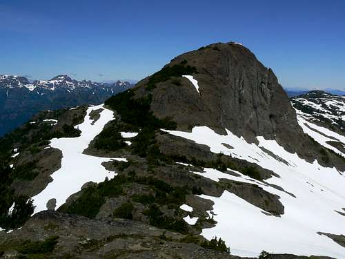 Mt Adrian Mt Adrian |
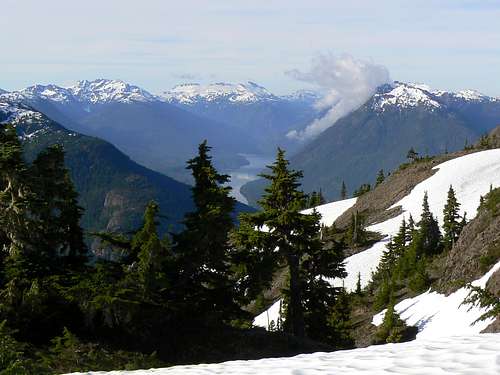
Adrian sits right at the southern end of the height of land known as “Rodger’s Ridge” that climbs out of the headwaters of Sihun Creek to the north and many of its occasional visitors come from that direction. The western slopes of the mountain drop precipitously into Buttle Lake nearly 1,600 metres below.
Mt Adrian west aspect
The mountain has twin summits. The northern main summit sits above the saddle between the two with about 150 metres of prominence.
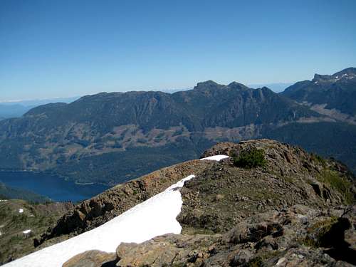
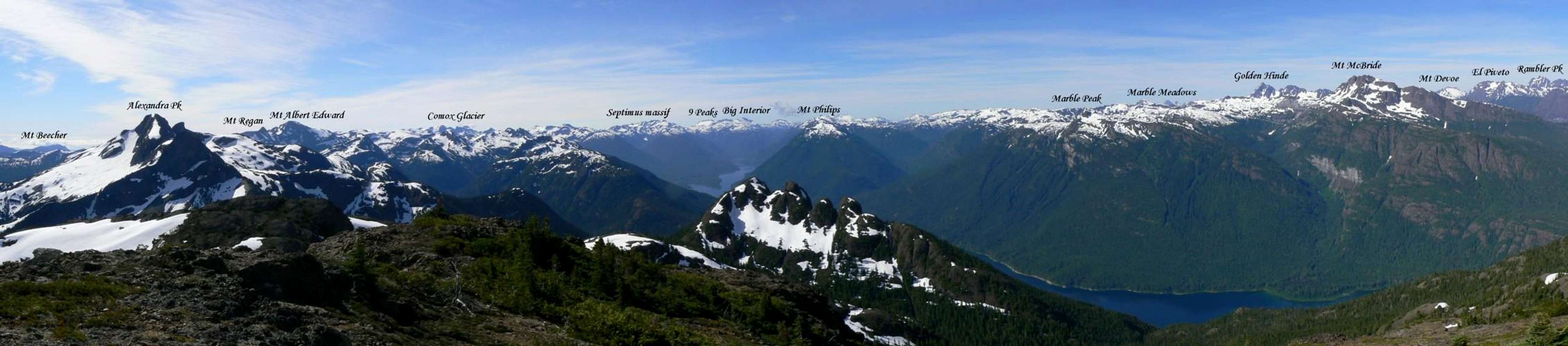
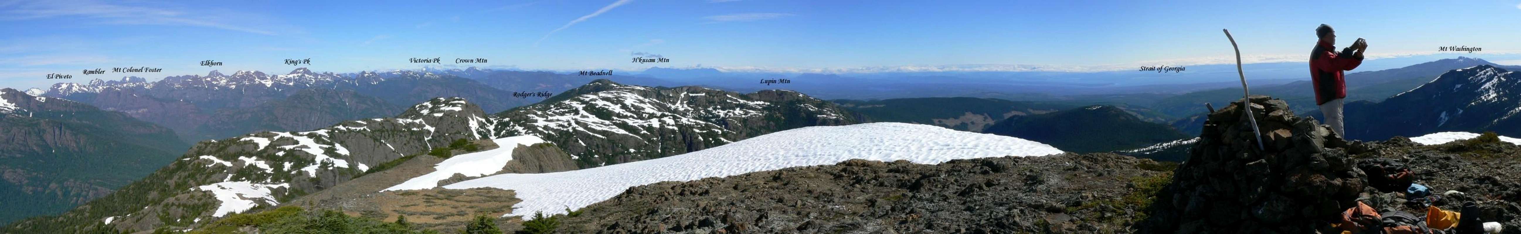
Adrian’s relative isolation and situation directly above Buttle Lake provide the climber with 360° views across almost the whole of Strathcona Provincial Park and beyond, as well as views down the length of the lake and east to the Strait of Georgia and the mainland mountains of the Coast Range. Views even better, in my opinion, than neighbouring Alexandra Peak.
The summit has a register that consists of a plastic tube and a several pieces of loose paper. There’s nothing to write with. Adrian was not on the list of Island survey points and, therefore, there are no survey monuments.
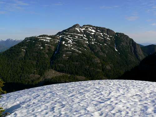
Mt Adrian south aspect
Those who do not to live on Vancouver Island might be surprised to learn that the mountain is not in any park and enjoys no protected status whatsoever. The mountain sits entirely on private land owned by the Timberwest Corporation. Logging reaches far up all accessible sides of the massif and stops only when the limit of practicality is reached. As a result of this unfortunate state of affairs, access to Adrian is sometimes at issue. Refer to the “Getting There” and “Approach” sections below.
The best candidate I can find for the source of Mt Adrian’s name is W.A. [Adrian] B. Paul who together with David Guthrie and Henry Ellis, is credited with the first ascent of nearby Alexandra Peak in 1930 as well as many other exploratory ventures throughout the Forbbiden Plateau area.
Mt Adrian - on the right - east aspect
Getting There
Vancouver Island can be reached directly by air from Toronto, Vancouver, Seattle, Calgary, Edmonton and recently from San Francisco to either Victoria, Nanaimo, Comox or Campbell River and by ferry from Port Angeles to Victoria on The Coho and on BC Ferries from Vancouver to Victoria or Nanaimo. Public transport on the Island is notoriously poor and anyone arriving by air would be advised to rent a car.The approaches to Mt Adrian require you to negotiate steep, narrow industrial roads that have or are being used to log the surrounding mountainsides. The western approach via “Buttle Bluffs Road” requires a high clearance vehicle with 4WD and experience with difficult off-road driving. The northern approach via Granite Main is mostly on main line with no cross ditches and can probably be safely negotiated with a normal passenger sedan.
Closed gates and/or limited hours of access are frequent occurrences. Before you go contact Timberwest in order to determine the best plan of attack and current conditions on the approach to Alexandra.
Approaches
Approach the mountain from the south on the Inland Island Highway 19.Sihum Creek/Rodger’s Ridge Approach
From Campbell River at the end of the freeway section of Highway 19 take highway 28 west towards Gold River. Drive for 17 km from the silver bridge at the junction of highways 19 and 28 and find the Quinsam Mine road on the left.After 3.3 km bear right and leave the road to the mine on Argonaut Main.
Drive a further 16 km southwest past Quinsam Lake to the junction of Argonaut Main with Granite Main and turn left. The onward route is straightforward and the most travelled road is the one to follow at any junctions.
 Sihun Creek approach roads Sihun Creek approach roads |  Rodger's Ridge N trailhead Rodger's Ridge N trailhead |  Rodger's Ridge N road end Rodger's Ridge N road end |
- At N49 51.025 W125 32.881 keep left
- At N49 49.545 W125 31.867 bear left
- At N49 48.584 W125 32.243 at a prominent junction keep right for the small lake and the north part of Rodger’s Ridge or left to get as close as you can to Beadnell Lake
- If travelling to Beadnell Lake drive 1.2 km and turn right up a rough spur at N49 48.311 W125 31.748. 4WD may be necessary from this point. I’m not aware of a trailhead but this road does approach to within 200 metres of the lake shore. Try starting from N49 48.111 W125 31.779, about 300 metres up the spur.
- If travelling via the small lake proceed 2 km from the junction to N49 48.150 W125 33.257 and find a spur on the left. Drive up the spur 150 metres to N49 48.095 W125 33.343 and find an obvious use path and a flat spot for one or two vehicles to park.
Buttle Lake Approach
Proceed beyond the turn off Highway 28 for the mine. From the silver bridge in Campbell River drive 47 km and enter Strathcona Park at Elk Portal. Exactly 1 km further on highway 28 makes a right turn over the bridge at Buttle Narrows. Ignore the turn and carry straight on down the paved Buttle Lake Parkway (also known as Westmin Mine Road) for ~ 10 km and find “Buttle Bluffs Road” on the left at N49 45.899 W125 35.048 – about 400 metres south of the Lupin Falls day use area.Keeping right and/or uphill at any junctions, drive the steep and narrow road about 7 km southeast and up to the junction of two high hanging valleys with logging roads everywhere. One branch of the valley turns southeast down towards Pearl Lake and the other northeast, up towards the high pass between Alexandra Peak and Mt Adrian from where Alexandra Creek drains the mountains east and down to the Oyster.
 Road washout in upper valley Road washout in upper valley |  Right hand valley roads Right hand valley roads |  Left hand valley roads Left hand valley roads |
Take the left hand fork labelled “Prk 300” and drive the remains of the road as high as you can towards Alexandra Peak and Mt Adrian. From the valley junction on some severe washouts are currently (July 2010) apparent. My 4Runner made it a further ~ 1.5km to 1,200 metres elevation before reaching the limit of its capabilities but we noted that others had made it even further.
WARNING
“Buttle Bluffs Road” is not for the faint of heart. Particularly in the upper reaches it’s extremely steep, narrow due to rockfall and is beginning to slough off in places. Don’t try to drive it alone.
A “spotter” is essential to guide you through some spots which were just wide enough to get my 4Runner through with the near side wheels on the last few inches of road overhanging the 1,000 metres drop to Buttle Lake below.
Summary of Summit Routes
From the North via Rodger’s Ridge/Mt Beadnell
 Rodger's Ridge route Rodger's Ridge route | Reaches Rodger’s Ridge from any of the convenient high roads below and follows the ridge south, over Mt Beadnell, the high point on the ridge, to the foot of a high point west of Mt Adrian. Travels over the high point and then swings east to the foot of Adrian itself. Follows the ridge up to the summit staying on the right (south) to avoid steep ground. |
South Slopes Route
 South slopes route South slopes route | Leaves the main high valley road “Prk 300” just before the latter reaches its highest point. Travels up the south slopes via the communication station there and right over the south summit. Drops to the col below and then up the obvious left hand (west) ridge to the summit. |
Red Tape/Safety Considerations
Although there are no fees to pay or forms to fill in, a pre-trip conversation with Timberwest regarding access might be in order.As of July 2010, the current situation is as follows:
Argonaut Main. No restrictions that I know of.
Buttle Lake. There is a gate but no gatekeeper. Day to day opening. I have heard of folk going this way and getting locked in. We were able to gain access, stay 2 nights and exit without problem. Two days later the gate was locked.
The summit of Adrian looks right over to the towns along the east coast and consequently we enjoyed full cellular service (Telus) from there.
This is private land and there’s nothing in the way of an intentions system. Make sure, therefore, that you have left a detailed trip plan with someone responsible. The RCMP and the appropriate SAR agency will respond in an emergency but it is up to you to have the mechanism in place that will initiate the call-out process if it becomes necessary.
South Buttle Lake area from Mt Adrian
Camping
I know of no restrictions on camping along the length of Rodger’s Ridge, although the summit register confirms that most who undertake this route do so as part of a day trip.If you are successful in getting up Buttle Bluffs Road, there’s nothing and nobody in the way of restrictions. It’s all a bit ugly with the piles of logging slash everywhere but, if you search around, the chances are you’ll find a spot of old growth to camp in with some nice views. Try N49 44.092 W125 31.302 at the confluence of two streams with some big trees for shade.
Light no fires and, since giardia is well documented on the Island and since you’ve brought a vehicle this far, include a barrel of water in your supplies.
Weather
Nearest point forecasts:East
West
Useful Links
For more information refer to Island Alpine – A Guide to The Mountains of Strathcona Park and Vancouver Island, Philip Stone, Wild Isle Publications, 2003, ISBN 0-9680766-5-3For general backroad information and directions get hold of a copy of Backroad Mapbook. Volume III: Vancouver Island
Don't go on any Island trip without checking out Lindsay Elms excellent Beyond Nootka website.
Summit Panoramas
  |
 |