Sierra Challenge 2012 — the alternate exploits of eddie fonner
![Oh Deer]()
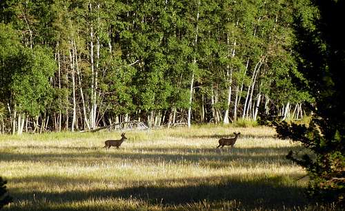
Eocene: from Twin Lakes (i.e. Mono Village, "trailer park hell") via Ice Lake Pass, and descending Blacksmith Creek. William and I opted to take the Robinson Lake trail with Scott and Phil, thinking our route more indirect but less taxing than Bob and the others' cross-country jaunt. We encountered some minor difficulty following the use trail up Little Slide Canyon but still reached Ice Lake and its pass relatively easily. After traversing around to the southwest ridge, we started up a convenient ramp system that took us around to the south side of the peak, and eventually to the saddle with the west-northwest and southwest ridges. From there it was a brushy push to the summit, punctuated by sandy rocks and some short scrambling. We somehow missed the register, but still enjoyed the fantastic views as we took a break. I wolfed down my leftover steak sandwich, and we then decided to descend the loose, sandy slopes into the Blacksmith Creek drainage. The first 1,000 feet down the sand flew by in under twenty minutes. We then passed by some scenic meadows nearby Glacier Lake—however the rest of the canyon was characterized by boulder-hopping and bushwhacking which seemed to take forever. I was damn impressed (but probably shouldn't have been surprised) Burd and his posse managed its ascent in just three hours…
![Mills]() Mills on the approach
Mills on the approach
Mills: from Mosquito Flat (complicated by our "California-Alpine" start of 9am). It was an easy and scenic approach from Ruby Lake up Mills Creek, until we struck off to the base of the mountain. The east couloir was steep, loose, and not-at-all recommended, especially in such a low-snow year. Bypassing the chute's chockstone from its crack on the left turned out to be the crux; however it still took an eternity to ascend to the summit plateau, cautious not to smash each other with its thousands of precariously-perched projectiles. We nearly turned back due to the impending clouds, but doggedly persevered to the summit and started down just before the rain began. We descended the couloir and slowly retraced our steps down Mills Creek for a few hours to the trail. Cold and wet, we returned to the car just as nightfall overtook the surrounding forest.
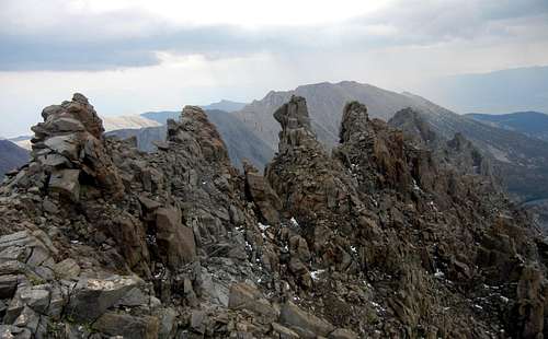
![Humphreys]() Humphreys from Checkered Demon
Humphreys from Checkered Demon
Checkered Demon: from North Lake via Piute Pass. After barely missing the other challengers at the trailhead, we easily rambled to the pass and handled the cross-country over Humphreys Basin relatively efficiently. Upon reaching a small snowfield, we learned it was my friend Duc's first encounter with the naturally-occurring crystallization. From the small lake just west of the peak, we then climbed the headwall towards the northern summit. After reaching the ridge, we had to backtrack once when blocked by some small gendarmes unseen from below. Traversing beneath the difficulties, only William and I were foolhardy enough to attempt the final hundred feet. There were a couple fun, exposed class 3 moves while ascending the top of our route up the west face. The view of Humphreys was spectacular, but we didn't have time to linger. Rain started to fall just after we departed from the summit, requiring a slow and careful descent. Progress was easier once back into the basin, slogging several soggy hours back to the car.
Today also marked the first Sierra dayhikes by two of my good friends from SF—though rebuffed by steepness and impending weather very close to the top, they performed admirably well throughout the whole, longer-than-expected day (almost putting Will and myself to shame). Also on the way down we ran into a soaked and exhausted-looking chap near Loch Leven who was eating straight from a jar of honey. He told us that his sons had abandoned him, leaving him apparently without a raincoat to hike back alone. He declined our offer of help, moving slowly but deliberately downhill. Upon reaching the trailhead, we visited the pack station and notified a forest service member of our encounter with the lost hiker. We learned that his sons had returned two days prior, apparently leaving dad for dead. Perhaps they were hoping for a premature insurance payout? The search party was called off, and thankfully we saw him trudging back to the trailhead just a few minutes later.
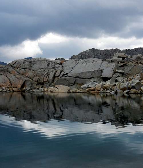
![Raindrops]() Raindrops transform a lake's surface
Raindrops transform a lake's surfaceSki Mountaineers: from South Lake. We again started behind the group, and early on I tripped over a root protruding from the trail, stupidly falling to the ground and slicing my hand open pretty nicely. After a minor delay to patch myself back up, we continued down the trail toward Treasure Lakes. Heading cross country over some broken benches, easy slabs then took us to the top of a small ridge. We contoured around and into the drainage east of the challenge peaks, choosing a line up the broad, sandy slope towards Ski Mountaineers. We ran into Laura and a couple other challengers who were on the descent and inquired about the ridgeline to peak 13,000'—"it looked really shitty." Reaching the top just before noon, we had a short break and again saw that rain was imminent. The first drops started to fall on our ironically-rocky descent (no skis to be had). Although peak 13,000' taunted us from a short distance, we decided that drying off a couple hours earlier outweighed the other half Challenge point. I figured that i already had less peaks from this year's Challenge than Bob and the other top contenders, and kind of liked having a fractional score anyway. So after a brief stop at a small lake to devour some canned trout, we uneventfully retraced our steps downstream—taking a shortcut around the sandy, talus-strewn shores of South Lake—reaching the trailhead around 4:30pm.
![Gendarme]() Inconsolable
InconsolableGendarme: from South Lake. I got off to a late, slow start, happily lumbering along past Long Lake and the other scenic environs. It was around 9am when I neared Bishop pass and left the trail. Although I read Secor's description several times and spent some time eyeing the route ahead, I somehow mistook a chute between Agassiz and Aperture for Jigsaw Pass and didn't realize it until I was two-thirds of the way up. I had figured i could either tag Aperture from the col or downclimb a short distance on the other side. It wasn't climbable from the saddle, so I dropped down a few hundred feet, refilled my water from a stream running through the glacier NW of Agassiz, and reassessed my position. I spotted a possible ascent chute up the east face of Aperture, enjoying a nice class 3 climb until a couple hundred feet below the summit. I thought I could make the top and start down the north face of the peak toward Jigsaw pass and Gendarme, and it was at which point the clouds suddenly enveloped the mountain above. Furious wind, rain, and hail ensued. Marooned at 13,000', I was very fortunate to spy a large overhanging rock, and underneath I hid. I put on all the clothes in my arsenal (jacket, rain pants and gloves), and hunkered down for a while, cursing the combination of poor decisions. Hail and rain pelted the landscape for nearly an hour, but fortunately lightning was never a real threat. After the worst of the storm had subsided, I squeezed through a gap in the rocks onto the north face of the peak—probably 100 feet from the summit, I decided that descent was more prudent than tagging the bonus peak. Through more rain and hail I downclimbed some sketchy, slick class 3 rock, finally making it to the bowl between Aperture and Gendarme. It was getting late, but fortuitously the weather then cleared, taunting me with blue skies overhead. Tempting fate once again, I dropped my pack and tenaciously clambered up talus and broken benches to the summit of the initially-intended peak as quickly as possible. After snapping the few requisite summit photos, I retreated the way I came, regained my pack, and headed up toward Jigsaw Pass. Now fog had again overtaken the basin and I could no longer see the tall peaks surrounding me. Aiming for where I hoped I had seen the pass earlier, I climbed over large boulders until nearly on the north slopes of Aperture again. Didn't even consider gaining more elevation than necessary. I was overcome with relief as I spotted the tall pole denoting Jigsaw, and I knew I was home-free. I could see the rainclouds directly over Bishop Pass and Dusy Basin below, but thankfully it was all downhill from there… I befriended one other damp, weary hiker on the way down, redirecting us to the correct trail after we had both took a wrong turn and started an ascent back toward Bass Lake. I then met his friend Kellen back at the trailhead and was able to hitch a ride back into town.
![Middle]() Middle Pal & Norman Clyde
Middle Pal & Norman ClydeBig Kid: from Glacier Lodge. I booked it down through Big Pine and just got to the trailhead to start with the group for the first time in five days. Bob and company headed straight up the mountainside, but still pretty groggy I accompanied Michael, Tom, Ron and a few others on the trail toward Brainerd Lake. We carefully crossed the south fork of Big Pine creek via a skinny tree branch, leaving the trail just before it dropped down toward Willow Lake. I followed the others on an ascending traverse up a talus slope to where the gradient eased off. From here the summit rose another 1,500' of mostly-solid talus. Chugging upwards I reached the final ridge to see Bob and the gang already heading down, and reached the top along with Ron shortly after 11am. I took an extended break to admire the views and enjoy the day's much finer weather. Opting for the direct way down, I happily took the easy bonus Kid then slowly trudged down a sandy gully for a few thousand feet, stopping perhaps a dozen times to adjust my gaiters and empty rocks from my shoes. After reaching the parking lot, I washed off in the creek and headed back to town.
Round: from near Glacier Lodge. I rationed another easy day would be preferable to Bob's planned death march, but as always it was a longer day than initially thought. We first overshot the trail up the hillside until turning around and intersecting the right path a short way up the small drainage past the horse stable. Negotiating a couple annoying sandy sections, it was with pleasant relief that we reached the flatter, and still-mostly-shady Logging Flat. Then climbing the ridgeline over to High Meadows, we followed the trail over a gushing Baker Creek and past an old-looking cabin of some sort. Nearby we spotted the network of 4WD roads, and from here it would be a pretty tame walk to the summit. It still took a little while to cover the 4 or 5 miles to the top, punctuated by a final 75 feet of class 2 hillside. On the way back Sugarloaf seemed too tempting to pass up. There were nice views from the top, but we quickly tired of its carby sweetness and departed after fabricating a small register. Then it was a few hundred feet of boulder-hopping down to the road and a couple more hours plodding back to the trailhead.
![Sunrise]() Sunrise over Owens Valley
Sunrise over Owens ValleyUniversity: from Onion Valley via University Pass. At the parking lot shortly after 6am, it took about an hour to reach the placid Robinson Lake. From here I contoured around the east side of the lake and struck cross-country up towards University Pass. I followed bits and pieces of use trail, climbing through boulders, slabs, and talus to the moraine beneath the pass. The last few hundred feet were pretty loose, but thankfully there was a lot of sand to cushion the falls of larger projectiles. From the pass it took another 90 minutes to reach the top, slinking my way up the gentle, sandy slope. I admired the views of Center Basin and the multitude of peaks surrounding, but didn't stay at the top long as more clouds loomed nearby. Luckily only a few drops fell on the descent, as I bounded down the sand and utilized the even-steeper variation of U pass. Just after reaching the trail again, I bumped into one couple who had hauled a huge raft up to Robinson Lake and another pair accompanied by a massive canine. Pack it in, pack it out…
Cirque: from Horseshoe Meadow via Cottonwood Pass. We arrived at the Lone Pine visitor center shortly after 9am, but were denied permits and told to come back after 1:30 after all cancellations had been processed. After driving to the highly-elevated trailhead, we had an enjoyably flat jaunt through Cottonwood meadows, then worked the mellow switchbacks up to the pass. Traversing the trail up and around the crest, we struck off cross-country near the small drainage SSW of the peak. We walked up past small rocks near a saddle between Cirque and peak 12,525', dodging larger boulders and summiting just after 1pm. Hopefully some permits would remain for us, as we would certainly not be back as early as we'd hoped (one would think the pattern would be apparent by now, but perhaps we're happy with this ignorance). Aside from stopping and putting on our jackets as protection from a short bout of hail and rain, we were making decent time—jogging down the trail and then cross-country beneath the pass—until i realized that my sunglass case had fallen out of my backpack. Shit, karma for cutting the long switchbacks? I begrudgingly began to backtrack over a mile in vain, as William headed back to the permit office. I thoroughly scoured the trail halfway back up to Cottonwood pass to no avail. Resigning my seemingly-lost spectacles (and possible Challenge disqualification for leaving gear on the mountain), started back. In attempt to retrace my steps as closely as possible, I would turn to my GPS and see approximately where i had been, sometimes checking a 10 foot radius when my previous path was unclear. At one section off the trail, I somehow spotted the beige case amongst a cache of similarly-colored dried pine needles. As I let out a bellow of excitement, i definitely startled a few cows grazing in nearby Horseshoe Meadow. Securing my gear and breathing a sigh of relief, I sheepishly made my retreat to the trailhead.
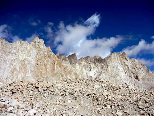
![Whitney]() Whitney Massif
Whitney MassifWhitney: from the Portal. Up early and on the trail shortly before sunrise, I was incredibly grateful for the easy path up the gentle gradient. Hours passed mostly in silence as we first passed Mirror and Consultation Lakes, pausing near the last campsites to snack and steel ourselves for the upcoming switchbacks. I lost count as we zig-zagged upwards, but there seemed to be less than 99 switches. After reaching tail crest, we contoured along the west side of the ridge until spotting the ascent chute towards Mt. Muir. Dropping our packs, we scrambled up a hundred feet of talus along a nice use trail to the base of some steeper rocks. We scouted a couple routes, but ultimately didn't see the easiest class 3 line & impatiently turned back to the trail. Moving along further, William went ahead while I scaled first Crooks then Keeler Needles. Intermittent fog swept past Whitney's summit, but fortunately rain never threatened on the day. Satisfied with the easy bonuses & happy to see the end of the trip's cross-country travel, I regained the trail and negotiated the final section to the top. There we chatted with several groups, sharing some celebratory champagne & a quick puff on my inhaler. As we were enjoying our lunch, one woman made the summit and immediately burst into tears. The sun had just broken through the clouds, and she wailed about being touched by god. I hope it was consensual. Finally, we snapped some goofy summit photos, reshouldered our packs and started back. The return was largely uneventful, characterized by what felt like an endless amount of stumbling downhill and thoughts of home. I stopped several times for short rests and began to feel better after losing some elevation. Both my Ipod and legs were nearly dead, but there was just enough power to get us back to the trailhead around 6:30. Cheeseburgers and beer, ahoy!
Wrap-up: I resorted to climbing many alternate peaks, as I simply wouldn't have been able to manage Bob and the others' killer itinerary. Perhaps it would have helped if i had seriously trained for the event, but i was pretty happy to have survived well and even felt a bit stronger for the experience. I probably would have attempted more peaks on the final day if I had known how close i was for the polka-dot jersey, but throughout the week i was almost entirely oblivious to the other Challengers' stats. I came within 100 feet of three summits—Aperture, Muir and Discovery—but ended up turning back due to weather, sketchiness, and/or exhaustion. Regardless, i'm elated to have challenged myself thusly and to have closely experienced such beautiful and rugged terrain. Many thanks to all who helped along the way: Bob, Duc, William, and especially Esther for all her care and support. ¡Viva Las Sierras!
Stats: 10 days, 9.5 challenge peaks & 4 bonus. ~138 miles hiked (~45 cross country), ~47,250' of elevation gain/loss in 108 hrs 40 min


Comments
Post a Comment