
|
|
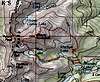
Route |
|---|---|
|
|
40.09890°N / 105.6164°W |
|
|
Hike |
|
|
Most of a day |
|
|
Class 2 |
|
|
Approach
Begin this route in the usual fashion, beginning at the Beaver Creek Trail on the North side of the Mitchell Creek Trailhead parking lot. Follow the Beaver Creek Trail, through a set of switchbacks, to just above treeline where the trail splits. Take a left. You are now on the Mt. Audubon Trail.
 |  |  |  |  |
Route Description
Once on the Audubon Trail, your destination will be clearly visible. You will wind through switchbacks, around a snowfield and finally level out in a lush tundra plain, full of wildflowers, just North of the bulky summit of Audubon. There are great views of the mountains to the North, including Longs Peak and Mt. Meeker. Turn left and begin the steep hike up the North Face of Mt. Audubon. Following cairns will make this last push to the summit a bit easier. There is also a faint, spotty, trail at times, to help keep you on the right course. The view from the summit is great. The rugged peaks to the South make for some great photos.
For a great loop hike, don't descend the way you came up. Descend via the Southwestern ridge. Be careful, there are a lot of unstable, loose boulders you will be walking on. Nothing too dangerous, but to be noted. From here, you can take the short scramble up Paiute Peak (well worth the extra effort) or you can immediately descend the VERY steep gully, known as Crooked Couloir, at the low point in the ridge between Audubon and Paiute. Crooked Couloir takes you directly to Upper Blue Lake, with wonderful views of Mt. Toll. Be very careful while descending this couloir, there is an abundance of loose rock. Be extra mindful of hikers below you, and if there are hikers above, keep your eyes open for falling rocks. This gully is nothing but loose rock and sand, and in some places, very steep. Once at Upper Blue Lake, follow its outlet stream to Blue Lake. From here, it is a short 2.5 miles back to the spot where you started.
This is one of the greatest day hike loops around!!
Essential Gear
Bring the essentials (water, food, rain gear, extra layers, map, compass etc....). If you are with one other (or more) people, it wouldn't be a bad idea to bring a helmet for the gully. Other than that, common sense should be enough.
You will need USGS Topo maps for the "Ward" and "Monarch Lake" Quads.
Miscellaneous Info
If you have information about this route that doesn't pertain to any of the other sections, please add it here.
georgbetsy - Aug 15, 2004 11:12 am - Hasn't voted
Route CommentA climb of the East Slopes route up Mount Audubon can be combined with the summit of a small 12706ft peak to the north-east of Audubon. This peak has been called "Notabon" by Roach and provides beautiful views of the surrounding area. It requires an additional 120ft of elevation gain and can easily be reached from the normal route. (It can be seen next to Audubon on the picture that I submitted earlier.)
RMdaytripsgrl - Jun 23, 2005 4:17 pm - Hasn't voted
Route CommentThe "very steep gully" is called Crooked Couloir. It provides for a nice glissade down to Blue lake when snow conditions permit.
smudge - Jun 23, 2005 8:11 pm - Hasn't voted
Route CommentThanks...I never knew it had a name!