"Let's get outta here"
My wife and I wanted to get out of the Seattle like weather that had settled into the Wasatch/Salt Lake area and the weather reports for southern Utah looked promising. One of the places I've wanted to visit for some time was
Mt. Trumbull, a very out of the way mountain in the middle of the Arizona strip. Armed with two Summitpost pages created by SP member Scott Surgent, one for
Mt. Trumbull, and the other for the
Kaibab plateau, we were ready for some good Arizona stuff (in warmer weather we hoped). My wife looked at the map and just raised her eyebrows and gave me that "look". She said "Count me in" which
meant that she was up to another of my crazy adventures. It was a chance to see some country that otherwise might never appear on her radar screen. Most sane people our age would be more content in heading down the interstate to stay at some nice motel and enjoy all those creature comforts
that make life a bit nicer. No, we were going to go out and bush camp and see another of those great areas that you normally wouldn't even hear of.
The Arizona strip is that land north of the Grand Canyon and south of the Utah border. Very lightly populated and now mainly the domain of government agencies (BLM, NPS, etc), there aren't any paved roads south of the one that connects Colorado City with Fredonia. It looked like our traverse of the area would easily involve driving over 120 miles of dirt roads so I had my truck well prepared with two spares, shovels, extra gas and supplies. It took us four hours to make the drive from Lehi to St. George and by the time we hit St. George, it was time to gas up at the Costco and go to our favorite place to eat, Ruby Tuesdays which isn't far from the Costco.
We ate lunch at Ruby Tuesdays in St. George and the waitress just happened to be familiar with the area we wanted to get to. She gave us a bit of history and comments about the roads we were about to take and made a couple of suggestions as well. For all that interest, she earned an even bigger than usual tip. Her advice was to bear fruit later on and we should have tipped her even more.
Heading south out of St. George on the River Road, we were soon on the dirt track that would take us all the way to the foot of not only Mt. Trumbull but serve us well in getting back to pavement 9 miles west of Fredonia. The road was washboarded in some places and relatively smooth in others and we made good time as we covered the 70 miles from the Costco in St. George to the trailhead for Mt. Trumbull.
Along the way we stopped in to view the
historic school house at the old townsite of Mt. Trumbull and caught up on its historic past. Along the way we passed very few vehicles and those we did pass seemed to be government trucks heading towards St. George to spend the weekend in civilization. We noted a couple ranch homes and some cattle but little else in this area that could be called a "big empty". Yet, it isn't empty and if a person had the time, it would be a great place to explore further.
Of course, we were set on getting to the base of Mt. Trumbull, one of Arizona's prominence peaks and only one of three in this whole area of northern Arizona (Mt. Bangs and the Kaibab HP are the other two)
Camping near the mountain
It had taken us four hours to drive to St. George from Lehi (near Salt Lake City) but it took over two hours to make the 70 mile drive from St. George.
I wasn't unhappy with that time since many sections of road, while never bad, did require slowing down at times to where a turtle might have gone faster than my truck. Interestingly enough, the Arizona safety people were really concerned about bicycles crossing the cattle guards safely. I wonder if bicycles ever go out into that area, maybe a reader of this trip report could enlighten me with more information on this subject.
After stopping at the old schoolhouse and learning its history, we proceeded on the last 8 miles or so to the trailhead, where a nice sign indicated that it was indeed the trailhead for Mt. Trumbull. A register was also placed strategically at the beginning of the trail for those who were hiking the mountain to sign in. I was surprised in looking at it to see that a couple people had hiked the mountain earlier in the day and almost every day had an entry as well.
We found an area just to the right of the trailhead where it was obvious that others had camped and we set up our tent there. It made a nice spot even though a lonely one since we were the only ones in the whole area. A nearby BLM ranger station had no one around (although one car came in later during the evening). After our tent was up and dinner was taken care of, a couple cars passed on their way to somewhere or perhaps to nowhere.
The evening and night was blissful and the stars of the milky way made their appearance known for awhile until the moon outshined most of the other heavenly elements.
The Hike
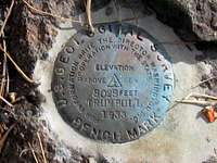
The next morning was just right temperature wise for the hike so at just before 7 I had grabbed my daypack and I was heading up the trail. First I stopped at the register at the beginning of the trail and signed in (your name isn't required since the powers that be want an indication of how much activity the trail receives). Initially the trail starts off wide and lined with rocks for a good distance but eventually it tapers down and becomes a trail as one would expect. And what a trail it is, well taken care of and it wraps around the mountain until it enters the woods, big Ponderosa pines that are really nice. Pine needles covered the path in many areas but the trail was always easy to follow. I had GPS'd the location of the summit but I didn't need that aid as the trail, well defined all the way for the most part, gives way to a good use trail, very adequately marked with cairns which were easy to follow, all the way up to the summit. The summit itself is marked by a large cairn and a nearby benchmark. While I found no register, I did spot another witness benchmark, not far away. I didn't find the second witness benchmark that Scott Surgent mentions on
his route page.
worthwhile links to check out for more info
Arizona Strip
Arizona Strip link 2
Arizona Republic article
History of the strip
Wikipedia
BLM Arizona Strip office
![Mt. Trumbull summit area]() Summit area
Summit area
Comments
No comments posted yet.