Our Route
In the signature picture, we took the route shown by the black line. This most likely is the route used by the majority of Mt. Waas climbers. The key is getting up the 4WD road, although you could walk it easy enough from Don's Lake.
Mt. Waas - Day 6
Mt. Peale was a great introduction to the La Sals and
Dennis, Andrew and I were eager to get to our next objective, Mt. Waas. Our climb of Mt. Peale is covered in another trip report (linked below as Day 5) and I mentioned that we stopped in Moab for pizza before heading up the roads that would take us to the Beaver Valley road. Following
Jennifer and Gerry Roach's directions found in their
www.cohp.org trip report (From Moab, drive 2.5 miles north on Hwy 191, turn right (east) onto River Road and go 15.8 miles. Turn right (south) onto Castle Valley Road, go 10.9 miles, and turn left onto Castleton-Gateway Road. Go another 10.4 miles to the Beaver Basin spur road, turn onto it and go another 1.6 miles. 2WD cars should park here. A 4WD vehicle can rumble on another 3.5 miles to the road's deteriorating end in the forest.) These directions were spot on and we found a flat spot to car camp very close to
Don's Lake. Don's Lake was the spot that where you could take a 2WD vehicle but not any further. Dennis and I made an exploratory drive up the 4WD track to see how far it would take us. With Dennis at the wheel of his Tacoma, we made it to the very end of the road, which actually ended in a streambed at 10,600 feet. The road had a couple of really bad spots but carefully driven it was doable. All part of our La Sal fun.
The next morning, July 6th, we headed back up to the end of the road and
parked at a flat spot in a small clearing below where the road turned up towards the streambed. We started up from the vehicles at 7 a.m. and made our way up towards
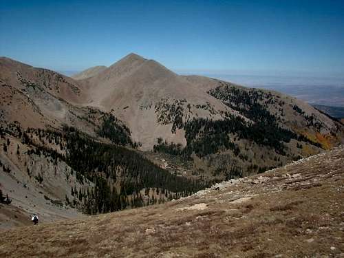
a saddle that had a cornice remnant of snow on it. To the left of the saddle, was a peak, 12163 that had a radio antenna on it which most likely would require a helicopter for servicing but it seemed strange to find that man made structure atop a peak seemingly in the middle of nowhere but of course, it seems like nowadays you find these structures in places you wouldn't even have imagined them in.
![It was necessary to go all...]() Heading for the saddle
Heading for the saddle
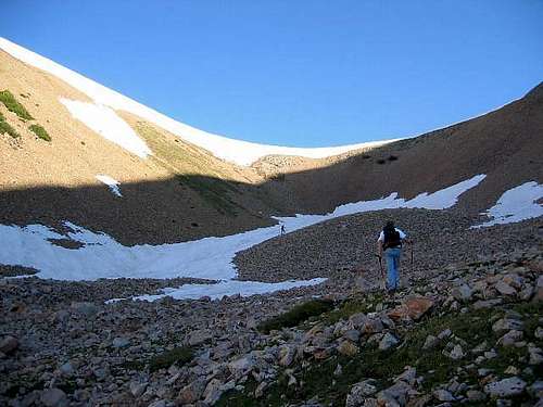
We found that the cornice was easiest to surmount at the far eastern end of the ridge where it was minimal. This spot was about 1000 feet above where we left the vehicles and we had 700 feet of major talus slope above us to
deal with. Thanks to the many others who had been up this mountain before us, a helpful use trail had been beaten into the slope which made our effort a lot easier. Before long, the steepness subsided and at 9 a.m. we stepped onto the summit. No wind, lots of sunshine and what a viewpoint.
Looking at the adjacent peaks of the La Sals made me vow that I'd be coming back to visit more of this area. Views down to Arches and Canyonlands were a bit hazy but still impressive.
![Looking south from the summit...]() The view south
The view south
Looking around the summit, we found two benchmarks but no register. One of the benchmarks was a witness one pointing to the key benchmark.
![Mt. Waas Benchmark (UT)]() Benchmark of Mt Waas
Benchmark of Mt Waas
Gerry Roach had mentioned in 1998 "There is a cairn and a register (unless it has disappeared, so bring one just in case)" Since I never seem to have a register and a container with me, I missed the opportunity to do my good deed for the day. I love reading the pages of a register to get a feel of who visits the summit but I found myself content to take some pics, eat a snack and just enjoy the views. After about a half hour on the summit, the three of us picked up our day packs and made our way carefully back down the talus to the saddle. I always hate to leave a summit but it has to be done. We were back at the vehicles in a bit over an hour and carefully drove back down the road to civilization. The road through the Castle Valley is a great drive as some great scenery is to be enjoyed as you make your way through it.
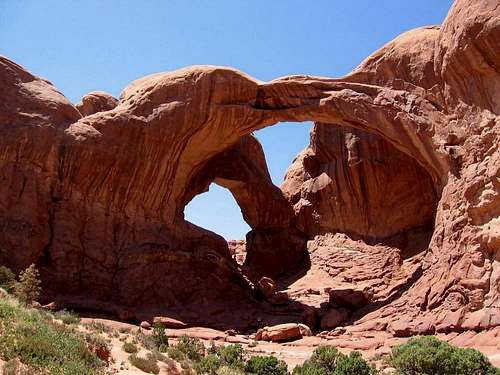
We headed for Moab and a nice lunch and then spent some time in Arches National Park, sweltering in the 105 degree weather as we visited many of the sights in Arches. The best sight of all though for me, was looking at the La Sals from a pull off provided in Arches for just that purpose.
Onto East Peak ....
Mt. Waas was an outstanding experience, our second day in the La Sals. I want to return to this wonderful mountain range to hike all of the peaks someday but these two days were a great sampler. After Waas, we visited Arches National Park and then headed for CastleDale Utah and to get as close to our day 7 objective, East Peak. A summary of the week in Utah is below,
In the month of
July, this is what I was able to do and see:
Day 1 - Naomi Peak of Cache County and the aborted Rich County effort.
Day 2 - Mine Camp Peak & camped out at 11K feet 2 miles from Fishlake Hightop.
Day 3 - Fishlake Hightop and
Bluebell Knoll. Drove to within 5 miles of
Mt. Ellen and camped. Went via Boulder & Burr Trail to Capitol
Reef Nat'l Park and then east into the Henry Mtn Range
Day 4 - Mt. Ellen and then drove via Hite, Natural Bridges Nat'l Monument
and up to a spot where we camped close to Mt. Peale
Day 5 - Mt. Peale. Then some time in Moab and drove to a spot where we
were close to Mt. Waas
Day 6 - Mt. Waas. Then spent time in Arches Nat'l Park before we drove to
a spot where we camped close to East Mtn.
Day 7 - East Mtn and a long drive to So. Tent Peak. Then drove to a spot a
few miles from Monument Peak.
Day 8 - Monument Peak and then drove up and did Eccentric Peak in the
eastern Uintas. From there I started my drive home. Left Eccentric TH at 5pm and drove into Kennewick the next morning around noon.
So far, six of the 8 days I had were now spent. Days 7 and 8 would be full days. In the 8 days, I did 11 peaks, saw two National Parks and a national monument, drove the Burr trail and went over Hell's Backbone into Boulder. Car camped every night and loved every minute of the trip.
![Peak 12163]() Looking up to Peak 12163 from the eastern end of the saddle. The climb up to Mt. Waas is behind me. Notice the antenna structure building on the top? Double click on this pic
Looking up to Peak 12163 from the eastern end of the saddle. The climb up to Mt. Waas is behind me. Notice the antenna structure building on the top? Double click on this picArches National Park was worth a stop
After we finished with Mt. Waas, we drove back through the Castle Valley and ogled at some amazing works of arts created by nature. However, fueled by a nice lunch in Moab, we headed for Arches NP to see a few sites before heading to our next destination. Unfortunately for us, it was 104 degrees in Arches that day and it was tough to come from the nice temps of the high La Sals to the heat of the desert but yet, the stop was worth the heat as the above pic shows and I particularly was impressed with Landscape Arch, another work of art by Mother Nature.
![Landscape Arch]() Landscape Arch
Landscape Arch


Comments
Post a Comment