
-
 5098 Hits
-
 83.1% Score
-
 16 Votes
|
|
Mountain/Rock |
|---|---|
|
|
46.59915°N / 11.01565°E |
|
|
Hiking, Skiing |
|
|
Summer, Fall, Winter |
|
|
8556 ft / 2608 m |
|
|
Overview
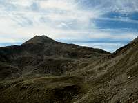
 The summit of Naturnser Hochwart / Guardia Alta di Naturno The summit of Naturnser Hochwart / Guardia Alta di Naturno |
A few weeks ago I submitted a page about one of the easternmost outposts of the Ortler / Ortles Group, a Sentinel, called Ultener Hochwart / Vedetta Alta. It stands high above to the south of St. Walburg in Ultental / Val d'Ultimo, over which it commands exceptional views. Right across the valley, almost exactly to the north stands another Sentinel, also called Hochwart, but generally (for the sake of clarity) named Naturnser Hochwart / Guardia Alta di Naturno.
Both mountains have more in common than only the name. They are of comparable height (2627m vs. 2608m) and dominate their immediate surroundings. Both rise out of a broad plateau-like ridge and both can be reached by a variety of hiking routes which head up for the mountains from all sides. Moreover, both mountains are made up from the same type of low quality crystalline rock, which can turn the ascent into a very uncomfortable affair.
 |  |  |
Naturnser Hochwart / Guardia Alta di Naturno is located on Marteller Hauptkamm / Cresta Principale di Martello, the longest of the ridges of the Ortler / Ortles Group, which accompanies Martelltal / Val di Martello and Niedervinschgau / Val Venosta Bassa on its southern side. While the highest mountains of this subgroup are located to its east, the ridge runs out in the direction of Meran / Merano. Here, a few mountain stand out on that ridge and Naturnser Hochwart / Guardia Alta di Naturno is the easternmost one of them. Beyond the ridge quickly drops beneath the timber line and only the direct neighbour, Staffelsberg / Monte Scaglioni, remains above it.
Naturnser Hochwart / Guardia Alta di Naturno is a popular hiking and ski touring summit even though from the valley floors you have to scale about 2000m of elevation. The most popular trailhead therefore is Larchbühel / Dosso dei Larici, a minor summit on the same ridge to the east, to which a combination of cable-cars and chair lifts leads from Lana. However, the hike is long - about 10km (one way) with an elevation gain of 900m. Yet, the wonderful 360° panorama justifies the efforts.
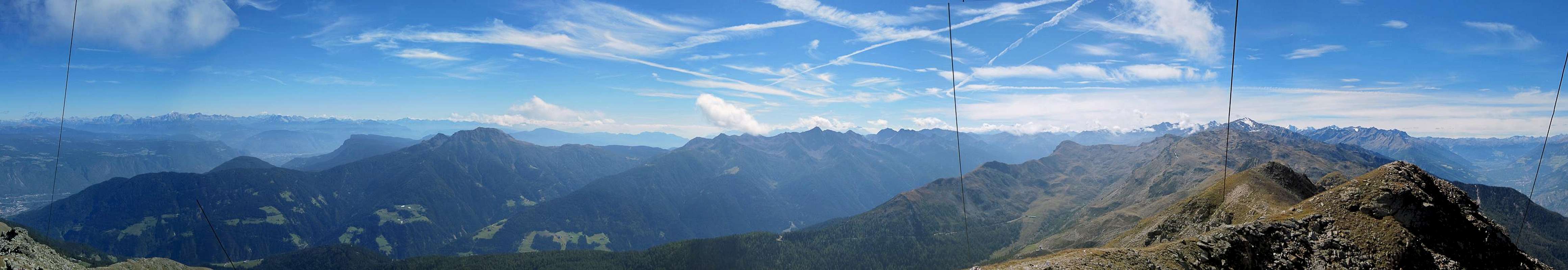
360° Summit Panorama
  |
Getting There
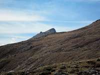
 Naturnser Hochwart / Guardia Alta di Naturno Seen across Vinschgau / Val Venosta
Naturnser Hochwart / Guardia Alta di Naturno can be climbed from at least four sides. There are many trails, which combine very close to the summit, to which three remaining trails lead. There are two trailheads in Ultental / Val d'Ultimo at St. Walburg and St. Pankraz. Another trailhead is at Naturns / Naturno in Vinschgau / Val Venosta, while the most popular route starts at Larchbühel / Dosso dei Larici,reachable by cable-car and chair lift from Lana.
- Take Brenner Motorway A22 to the exit Bozen Süd / Bolzano Sud
- Switch to SS38 towards Meran / Merano.
- Take the exit Lana and drive through the town
- For Larchbühel / Dosso dei Larici follow the signs to the cable-car.
- For the Ultental / Val d'Ultimo trailheads follow the signs into the valley
- At St Pankraz / San Pancrazio you can drive up the northern slopes of the valley to the Obersäge Sawmill.
- At St. Walburgyou can drive up to the hamlet Innerdurach.
- For Naturns / Naturno simply ignore the Lana exit and follow SS38 until you reach the village
Red Tape
 |
There is no red tape in the area. The lower slopes of the mountains are used for cattle, sheep and goat grazing and there are many gates and fences. Stay on the marked trails and close any gates you have to hike through.
Accommodation
 Naturnser Hochwart above Tschirland
Weather Conditions
Maps & Books
Maps
- Digital Maps
- Regular Maps
- Meran und Umgebung/Merano e dintorni
Kompass Map WK 53
1:50.000
ISBN: 978-3854910596
- Lana-Etschtal/Lana-Val d'Adige
Kompass Map WK 054
1:25.000
ISBN: 978-3854913542
- Lana, Etschtal / Lana Val d'Adige
Tabacco Map 046
1:25.000
- Meran und Umgebung/Merano e dintorni
Books
- Meran, Burggrafenamt, Ultental, Passeiertal
Kompass Guidebook WF951
Franziska Baumann
Kompass Verlag
ISBN: 978-3854913863
- Rund um Meran - Passeiertal, Texelgruppe, Ultental
Henriette Klier
Rother Verlag
ISBN: 978-3763342907