
-
 3474 Hits
-
 79.78% Score
-
 11 Votes
|
|
Mountain/Rock |
|---|---|
|
|
46.60576°N / 11.03572°E |
|
|
Hiking, Skiing |
|
|
Summer, Fall, Winter |
|
|
8015 ft / 2443 m |
|
|
Overview
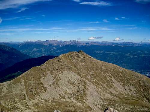 Staffelsberg / Monte Scaglioni as seen from Naturnser Hochwart / Guardia Alta di Naturno Staffelsberg / Monte Scaglioni as seen from Naturnser Hochwart / Guardia Alta di Naturno |
Staffelsberg / Monte Scaglioni is one of the easternmost mountains of Marteller Hauptkamm / Cresta Principale di Martello, one of the biggest subgroups of the Ortler / Ortles Group. The supgroup starts in the south-west, close to the centre of the range and runs out towards the north and east. While the south-western summits are still well above 3000m, the easternmost part of the ridge drops beneath 2000m, before dropping into the Etsch / Adige Valley near Meran / Merano. In this eastern part all of the summits are still beneath the timberline but as you turn west you reach the first rocky ridge, the east ridge of Staffelsberg / Monte Scaglioni.
At 2443m the mountain itself is well above the timberline. Its two ridges are forming a slightly curved line, running generally from east to west. The ridges rise at angles beneath 30° and only the summit itself is a bit steeper. It is separated from the east ridge by a profound notch, the main obstacle when traversing the ridge. Staffelsberg / Monte Scaglioni is located very close to the higher Naturnser Hocwart / Guardia Alta di Naturno, so that most visitors pass it on a trail which traverses the south face and head for the higher mountain.
 |  |  |
A narrow trail leads to the eastern base of the east ridge where a large number of cairns confuse about the best ascent route. The ridge is broader but covered by granite blocks, and thus requires a rock-hopping scramble to get to the top. Views are excellent with the Texel Group of the Ötztal Alps to the north and the Ultental Ridge of the Ortler Group to the south. On good days you will be able to see a good part of the Dolomites in the far eastern distance.
270° Panorama at the base of the summit ridge
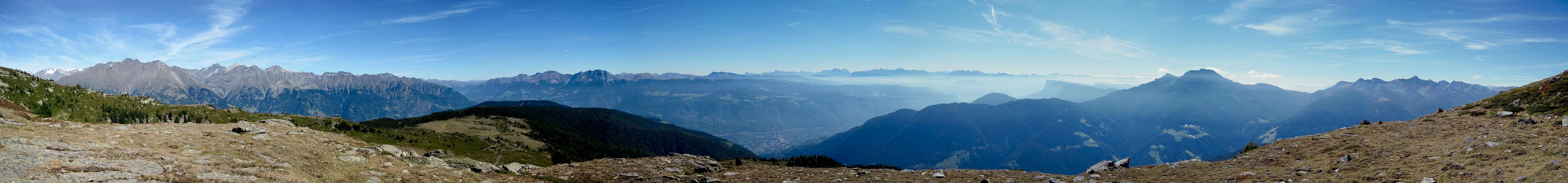  |
No 360° panorama for this summit. The batteries of the camera stopped working after this panorama and we only managed to get them back to work by keeping them warm. We had reached the summit of Naturnser Hochwart by then
Getting There
 Rock window on the Staffelsberg east ridge
Staffelsberg / Monte Scaglioni can be climbed from at least four sides. There are many trails, which combine in the vicinity of the summit or neighbouring Naturnser Hochwart / Guardia Alta di Naturno. There are two trailheads in Ultental / Val d'Ultimo at St. Walburg and St. Pankraz. Another trailhead is at Naturns / Naturno in Vinschgau / Val Venosta, while the most popular route starts at Larchbühel / Dosso dei Larici,reachable by cable-car and chair lift from Lana.
- Take Brenner Motorway A22 to the exit Bozen Süd / Bolzano Sud
- Switch to SS38 towards Meran / Merano.
- Take the exit Lana and drive through the town
- For Larchbühel / Dosso dei Larici follow the signs to the cable-car.
- For the Ultental / Val d'Ultimo trailheads follow the signs into the valley
- At St Pankraz / San Pancrazio you can drive up the northern slopes of the valley to the Obersäge Sawmill.
- At St. Walburgyou can drive up to the hamlet Innerdurach.
- For Naturns / Naturno simply ignore the Lana exit and follow SS38 until you reach the village
Red Tape
 Gold from Dung, an alchemist's dream
There is no red tape in the area. The lower slopes of the mountains are used for cattle, sheep and goat grazing and there are many gates and fences. Stay on the marked trails and close any gates you have to hike through.
Accommodation
 |
Weather Conditions
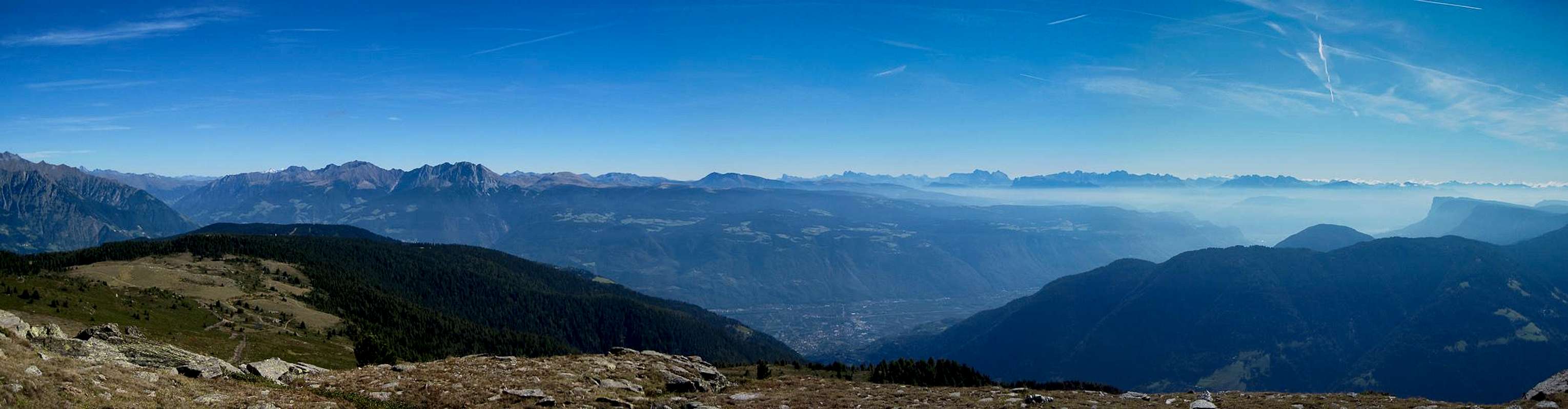
[img:694415:aligncenter:medium:The Texel Group of the Ötztal Alps]
Maps & Books
Maps
- Digital Maps
- Regular Maps
- Meran und Umgebung/Merano e dintorni
Kompass Map WK 53
1:50.000
ISBN: 978-3854910596
- Lana-Etschtal/Lana-Val d'Adige
Kompass Map WK 054
1:25.000
ISBN: 978-3854913542
- Lana, Etschtal / Lana Val d'Adige
Tabacco Map 046
1:25.000
- Meran und Umgebung/Merano e dintorni
Books
- Meran, Burggrafenamt, Ultental, Passeiertal
Kompass Guidebook WF951
Franziska Baumann
Kompass Verlag
ISBN: 978-3854913863
- Rund um Meran - Passeiertal, Texelgruppe, Ultental
Henriette Klier
Rother Verlag
ISBN: 978-3763342907