
|
|
Route |
|---|---|
|
|
39.96655°N / 105.29077°W |
|
|
Scrambling |
|
|
Half a day |
|
|
Class 3 |
|
|
Major Bushwhacking |
|
|
Overview
Nebel Horn is a secondary summit of Bear Peak, of which it forms the northern aspect. The easiest way to reach the summit is to gain the saddle at the base of Bear Peak's north ridge via the Fern Canyon Trail. The route proposed here, on the other hand, albeit more strenuous, allows one to find solitude, admire beautiful crags from up close, and practice bushwhacking skills. Access to Nebel Horn is usually prohibited from February 1 to July to protect breeding raptors. Additional closures are in effect when bats dwell in Harmon Cave (Usually April 1 to October 1). Please, plan accordingly. |  |  |  |
Approach
From the NCAR parking lot at 6040 ft, follow the signs for southbound Mesa Trail. Continue on the Mesa Trail until the Bear Canyon Trail forks on the right. Now watch out for the unmarked Harmon Cave Trailhead on your right. If you reach the start of the Fern Canyon Trail, you've gone too far. | 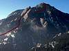 |  |  |
Route Description
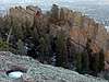
Climb the steep escarpment of the Mesa Trail and follow the Harmon Cave Trail. The cave is a steep quarter of a mile from the trailhead. The gate that blocks access to the cave is a real eyesore, but the bats don't seem to mind.The trail forks immediately before the cave. Follow the left branch, which continues to ascend towards the summit, until you reach the base of Seal Rock--a huge flatiron that tapers off into a rock tongue. The trail here forks again and the left branch, now a faint climber's path, contours the east and south sides of the Seal Rock.
Some easy scrambling will take you to the west end of the Seal, where even the faint climber's trail ends. If you head up and south towards the Goose you will then bump into the East Ridge, which will block your progress towards the summit. Instead, traverse west as you ascend. Your objective is to go around the west end of the East Ridge. This section of the route requires major bushwhacking on steep terrain.
From the gully between the East Ridge and the Upper Ridge you can ascend the highest points of both ridges with short class 3 scrambles. After the bushwhacking, the solid sandstone will feel good in your hands and the views from both high points are excellent.
From the summit (approximately 7560 ft), return to the gully and contour the Upper Ridge to the west until you reach the saddle between Nebel Horn and Bear Peak. Stay away from the cliffs, but otherwise do not lose too much elevation. After the climbing interlude, this stretch allows you to practice your bushwhacking skills again. From the saddle continue to Bear Peak or descend into Fern Canyon to the Mesa Trail. Once on Mesa Trail, turn left and you will soon leave on your left the Harmon Cave Trailhead as you head back to the NCAR parking lot.
There are several variants to this route. On the way up, you can stay to the north of the Seal Rock. This increases the bushwhacking, though. From the gully between the two ridges one can descend directly into Fern Canyon by turning east. However, I haven't tried this variant.
 |  |  |  |  |
Essential Gear
Standard hiking gear is enough. Long pants and sleeves are highly recommended. Carry plenty of water, even in winter. The Fern Canyon trail tends to be icy in winter: Choose appropriate footwear.Miscellaneous Info
The USGS quadrangle for Nebel Horn is Eldorado Springs. Nebel Horn is a climber's paradise. Good resources are Rossiter's guidebook, climbingboulder.com (Flatiron South), and the Flatiron Climbing site.The summit elevation shown at the top of the page, which is automatically inserted, is for Bear Peak.
If you know how Nebel Horn got its name, please leave a note here. It's plausible that it is German for Misty Peak, but a friend suggested that it may just mean fog-horn.