
|
|
Area/Range |
|---|---|
|
|
27.90400°N / 86.83370°E |
|
|
Hiking, Mountaineering, Scrambling |
|
|
Spring, Fall, Winter |
|
|
18373 ft / 5600 m |
|
|
Overview
These peaks are “trek-able” peaks without any permits, other than a standard trekking permit. They are not the official Trekking Peaks. All of them boast beautiful views of the great peaks in the Himalaya.In most of the world, all of these points or peaks would be considered to be high mountains, but here in the Himalaya, they are only minor peaks.
All of these peaks can be reached without technical equipment, thus the “trek-able” nomenclature.
Feel free to add any trek-able peaks and mountains that you are aware of as an addition/correction and I will integrate it into the page.
The purpose of this page is to gather information on all the peaks in Nepal that can be climbed by trekkers and with no red tape, other than trekking and national park permits. For this purpose, I hope you find the page to be useful.
The peaks will be listed in each section by order of elevation.
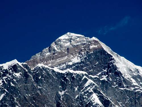 Everest as seen from near the summit of Hamugon.
Annapurna Region
Poon HillPoon Hill (3193 meters/10,475 feet) is one of the most famous viewpoints in the world. In Nepal, it is probably the second most famous viewpoint after Kala Pattar.
There are many options to extend a trip here, and the only limits to the length of the trek are time and imagination. There are lodges all along the route so there’s little need to carry a huge pack. The trek is very popular and can be very crowded, so in other words, expect a great trip with lots of mountain views, but don’t expect solitude. The trail passes through several interesting villages and different cultures, and the scenery is also very spectacular.
Since the trail never ascends to really high altitudes, it is suitable for most people including children. When my wife and I did the trek (and several others in the region), she was five months pregnant.
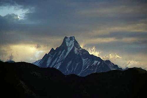 Macchapuchare seen from Poon Hill.
Langtang Region
Cherko Ri (Tsergo Ri)Cherko Ri (4984 meters/16,352 feet) is the best know viewpoint in the Langtang Region. It is an all day climb from Kyangjin and boast incredible views of Langtang Lirung and other nearby mountains. Thus far, the peak is not featured on Summitpost.
 The east face of Langtang seen from the summit of Cherko Ri.
Everest Region
Jaro RiJaro Ri (3940 meters/12,926 feet) is a little peak in the Khumbu which packs a surprising punch for what appears to be a small peak. The peak is not labeled on any maps I have and the only answer I could find from the locals as to its name is Jaro Ri. One photograph labels it as Kongde Ri, but one map shows Kongde Ri farther east. Interestingly, ri usually denotes a subpeak on a ridge, but this peak isn’t a sub peak of anything.
Regardless of the name, the peak is a great viewpoint and has an interesting stupa on top. When viewing the peak from Khunde and Khumjung, I expected the peak to be a nice viewpoint with a path to the top, but it was actually a challenging and fun scramble over gigantic boulders (which could make for some interesting bouldering). There was much bird life as well and we saw some really colorful pheasants.
Since most people spend an acclimatization day in Namche Bazaar or Khunde/Khumjung, this peak is a great way to kill a few hours and soak up the views of the mentioned villages and the mighty peaks of the Himalaya.
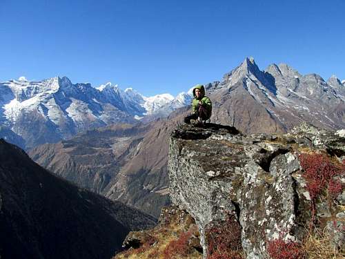
 Kantega and Thamserku from the summit of Jaro Ri.
Hamugon
Hamugon (4560 meters/14960 feet) is a nice little peak (well, at least by Himalayan standards it is “little”) above the famous Tengboche Gompa (Monastery). While most trekking and climbing itineraries recommend a rest day in Tengboche, Hamugon might prove just the thing for a “rest” day and makes a great acclimatization peak. It is certainly a recommended side trip in the Khumbu region, though it seems that few trekkers and climbers climb it.
Despite being one of the lowest of the 12 peaks we climbed on our trip to the Khumbu, Hamugon was also one of the most challenging. It is more difficult than it looks. The first 1/3 or so of the climb is easy up to the little sup-peak with the little monument. The next 1/3 of the climb is more challenging and follows a class 3 ridge. The final 1/3 of the climb is an exposed climb up ledges covered with grass and is quite challenging. I would still rate the difficulty as class 4, but it’s scarier than any 4th class route than I’ve done in Colorado, for example. The route is borderline class 5, but the climbing is on scary grass ledges rather than rock. The climb was difficult enough that the climbing Sherpa/porter whom we were with would not make the climb and neither would the other porter. Only Kessler and I made the summit, but the climb was difficult enough that I had to ditch the pack for the final few ledges.
The views from Hamugon are absolutely fantastic. Nuptse, the huge south face of Lhotse, Everest, Ama Dablam, Thamserku, etc, etc. are all visible in all their splendor. Kangtega is close, but much of the view of it is obscured by a ridge.
Hamugon itself is more a sub-peak of Kangtega than an individual peak. You can continue along the ridge, but the next peak on the ridge looks like a very tricky scramble. The ridge after that is definitely technical and would be mini-expedition territory.
 On the ridge while climbing Hamugon
Nangkartshang
Nangkartshang Peak (5083 meters/16,676 feet) is a spectacular viewpoint in the Khumbu. The only guidebooks I know of mentioning the peak as well as some trekking groups refer to this peak as Nangkartshang Peak, while some maps label it as Nangkart Tshang. Locals seem to call it Nangar-JOONG. Whatever the name of the peak is, it is a very worthwhile destination and a great place to soak in the views of the numerous fang-like peaks in the Khumbu region.
The peak is above Dingboche in the Khumbu and like almost all the other “walkable” peaks in the region, this one is more a sub-peak of a higher ridge than it is an independent mountain. The views are among the best of any walkable peak in the region as well. Kangtega, Ama Dablam, Nuptse, Lhotse, Makalu, Cho Oyu, Taboche, etc. are all visible in their full glory from the summit.
Since most people spend a few rest days acclimatizing in Dingboche before going to higher places such as Kala Pattar, Everest Basecamp, or Island Peak, climbing Nangkartshang is one way to kill one of the “rest” days and one of the most worthwhile as well.
Nangkartshang Peak has some minor scrambling, but for the most part is a walk up and other than the altitude, an easy ascent. It is much easier than some of the other walk up peaks in the area such as Hamugon. It’s a great half day excursion. The peak is climbed frequently, but not nearly as frequently as other similar peaks in the region such as Gokyo Ri and Kala Pattar.
Just beyond what is known as Nangkartshang Peak, the ridge immediately turns into a razor sharp knife edge. To continue one to higher peaks on the ridge without some serious technical climbing, you must descend Nangkartshang and skirt the cliffs to the north. You may reach the next peak without technical gear, but anything beyond that would be a mini expedition. The rock does seen fairly solid though and experienced climbers may be interested in pushing a difficult route between Nangkartshang and Pokalde (peak).
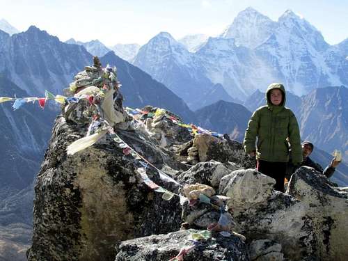 The summit of Nangkartshang Peak.
Taweche Towers
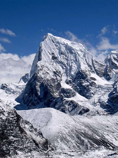
The Taweche Towers (5200 meters/17,060 feet) are some scrambling peaks above Pangboche. They are subpeaks of the spectacular Taboche. I have not climbed them, but there is a brief description on the Summitpost page.
 The summit ridge of the towers.
Gokyo Ri
Gokyo Ri (5340 meters/17,159 feet) is probably the third most famous viewpoint in Nepal, after Kala Pattar and Poon Hill. The views of Everest, Makalu, Cho Oyu, Gyachung Kang, Lhotse, and other peaks are very spectacular.
People like to argue as to whether or not the view from Gokyo Ri is better than that from Kala Pattar. Both points have very spectacular views and are well worth the trip.
From the village of Gokyo, most trekkers can climb the peak in 2-3 hours one way, if they are acclimatized.
 Looking East from the summit of Gokyo Ri.
Chukkung Ri
This peak (5559 meters/18238 feet) isn't as popular as Kala Pattar or Gokyo Ri, but has very spectacular views and has an unusual view of the South Face of Lhotse, one of the greatest mountain walls in the world. It is one of the best of the trek-able peaks in Nepal.
Chhukung Ri itself is sometimes listed as an official Nepalese Trekking Peak, but apparently only in error. Kyazo Ri 6186 meters is the actually peak that was supposed to be listed, but apparently someone goofed on the website (or so we were told). According to the National Park, you don't need a special permit for Chhukung Ri, in fact from their office and for a few rupees you can purchase a certificate for climbing it.
 On the summit of Chhukhung Ri.
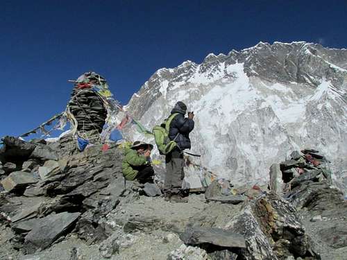
Kala Pattar
This is it; the most famous viewpoint in Nepal and probably one of the most famous viewpoints in the world (or at least one of the most famous viewpoints that can't be reached by car!). Everyone climbs this viewpoint to get a view of Everest, and what a spectacular viewpoint it is. Luckily though, Everest isn't the only view you get and the entire viewpoint is surrounded by jagged ice castles and some of the most spectacular mountains in the world.
Kala Pattar (5600 meters/18,372 feet) is located near the Everest Basecamp and also Gorak Shep, said to be the highest village in the world. There are two summits of Kala Pattar and both are worth visiting. One of the summits now adorns a cell phone tower!
 The summit of Kala Pattar.
Chhukung Tse
Chhukung Tse (5857 meters/19,216 feet), not to be confused with Chhukung Ri, is probably the highest you can get in Nepal without a trekking peak permit or climbing permit. It is also the highest viewpoint that is normal scrambled up by trekkers, though it isn't that well known or popular.
It is higher and more difficult than Chhukung Ri, but is accessible via a steep gully on the east side of the peak. An iceaxe is often required. The ridge between Chhukung Tse and Chhukung Ri can also be traversed, but it can be tricky and has some exposure.
It is possible to climb both the Tsi and the Ri in one day, if you are acclimatized, but it would be a long day.
At this time, there is no Summitpost page for Chhukung Tse.
 The Saddle of Chhukung Ri, which is south of Chhukung Tse.
Red Tape
Only standard trekking permits are required for any of these summits.Annapurna Region
For SAARC Nationals: 200RS (US $2.30).
For other Nationals (other than SAARC countries): Nepali Rupees 2,000RS (US $23.00).
Langtang Region
Langtang National Park permit is required - 1000RS (US $11.50).
Everest Region
For the Everest Region, the following Red Tape applies:
A Sagarmatha National Park permit is required - 1000RS (US $11.50).
Bring a Passport and Passport size Photograph.
A Trekkers’ management system (TIMS) is also required and cost $ 20.
Most guesthouses and hotels in Kathmandu frequented by Westerners can help you obtain a permit, especially in Thamel.
 Always tread lightly in the Himalaya.
Seasons
Mid September through mid May is the best time to trek and climb these peaks. The monsoon is from June through mid-September, and this is not an ideal time to go because the trails are very wet and the lower forest are full of leaches, plus it rains every day and clouds usually obscure mountain views.October, November, March, and April are the most popular months, and the trail and lodges can be very crowded. In my opinion, December is the very best month. The weather is cooler than the most popular months, but it is less crowded and prices in Kathmandu are a bit lower. December is also a very dry month.
On our first trip we had 47 days in the region during late November and mid-January with only one bad weather day. On the second trip we had two days of snow in a four week period early December to early January.
The winter season (late December through February) is also a good time to go with few crowds and usually good, but cold weather, but you can expect to have some snow and ice on the trails. Remember that there are villages along all the trails, so if you had to sit out some bad weather, it’s not that bad.
Averages for Tengboche at 3860 meters/12,669 feet elevation are below:
| Month | High (° F ) | High (° C) | Low (° F ) | Low (° C) | in. Rain | mm Rain |
| Jan | 39 | 4 | 16 | -9 | 0.51 | 13 |
| Feb | 41 | 5 | 16 | -9 | 0.94 | 24 |
| Mar | 48 | 9 | 21 | -6 | 0.91 | 23 |
| Apr | 54 | 12 | 25 | -4 | 0.98 | 25 |
| May | 57 | 14 | 30 | -1 | 1.14 | 29 |
| Jun | 57 | 14 | 37 | 3 | 3.74 | 95 |
| Jul | 57 | 14 | 41 | 5 | 11.02 | 280 |
| Aug | 57 | 14 | 39 | 4 | 10.43 | 265 |
| Sep | 55 | 13 | 36 | 2 | 5.51 | 140 |
| Oct | 54 | 12 | 28 | -2 | 2.83 | 72 |
| Nov | 46 | 8 | 19 | -7 | 0.35 | 9 |
| Dec | 43 | 6 | 17 | -8 | 0.08 | 2 |