
-
 52587 Hits
-
 92.25% Score
-
 38 Votes
|
|
Mountain/Rock |
|---|---|
|
|
27.96131°N / 86.68102°E |
|
|
17576 ft / 5357 m |
|
|
Overview
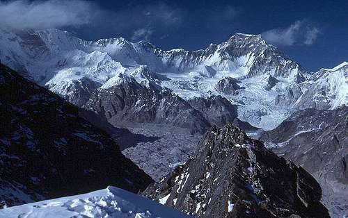 View from Gokyo Ri in 1986.
Gokyo Peak is located at the end of the Gokyo valley in the Khumbu region of Nepal. A very popular trekking destination, a sort of side trip for those who are in the region to go to Everest Base Camp. Many trip outfitters include a visit to this 17,988 ft. hill. The views from here are spectacular possibly surpassing those from Kala Pattar above Gorak Shep near the Everest Base Camp. Notable peaks to be viewed from this 17,988 ft. vantage point are Cho Oyu, Gyachung Kang, Lhoste, Everest and on a clear day Makalu. The vantage point can be reached in about 2-3 hours if you are acclimitized well, from the summer grazing village of Gokyo (15,720 ft). The point where 99 % of the trekkers go, is not the real summit but a shoulder at 5360 m (17584 ft.) All you will need is a Trekking Permit.
How to get there
 View from Gokyo Ri in 1986.
To get to Nepal you will have to fly from either India, Thailand or Singapore. To get to New Delhi India try (there are many others). Air India British Airways Air France Air Canada Kuwait Airlines Qatar Airways Lufthansa KLM Royal Air Nepal Once you get to Katmandu you will have basically two options: 1 - Fly on Royal Air Nepal’s Twin Otter flights to Lukla. A small air strip about ten days from Everest Base Camp ( eight from Gokyo peak allowing for acclimitization) 1 hour flight approx. 2 - Take a local bus, Mini Bus hired by you or your Sherpa provider to Jiri. This is a small village at the end of the road. From here it is about a 14-16 day trek to the Gokyo region. If you have the time do the walk. For three reasons: 1 - You will have a chance to walk through one of the most lush and beautiful lowland areas in Nepal. This is an area that a lot of trekkers miss when flying to Lukla. You will also cross over two high passes with excellent views in all directions. 2 - By taking 2 weeks to arrive in the Khumbu are and having already crossed over two high passes you will be better acclimitized once you arrive in the high peaks area. You will enjoy this more as you will be huffing and puffing less. 3 - You will be following the route taken by most of the early expeditions. There is a lot of history along that path, why not soak it up. You will also have the bragging rights that you did the same route as they in years gone by. Flying is fast and that has its advantages. But if you have ever been at Lukla after several days of no flights after bad weather you will understand this. (Trekkers fighting over seats to make their connecting flights home)
Villages you will pass through
 View from Gokyo Ri in 1986.
Flying into Lukla 9,350 ft.: (Note walking times are approximate a lot will depend on how you acclimitize.) Slowly decend to Phakding 8,700 ft. about 2 hr walk from Lukla, you will probably overnight here . The next morning after about 2-3 hours you will pass through Jorsale 9,100 ft. . Here is where you will pay a fee and enter the Sagarmatha (Everest) National Parkand. You will then continue for another 2-3 hours up hill to the main Village of Namche Bazaar 11,300 ft. This is quite an elevation gain especially for those who have flown in. You should rest here one to two days, doing small side trips ect. to acclimitize. The next day will take you through Shyangboche 11,800 ft. (approx) then onto the village of Khunde 12,600 ft. then onto Khumjung 12,400 ft. then you decend to near the river crossing at 11,950 ft. but keep to the left (do not cross the river to Phortse ) and continue through Tongba 13,175 ft. Gyele 13,400 ft. and Dole 13, 400 ft. to Lunza 14,400 ft. This should take a total of 4-5 hours. You should consider resting here for one day for acclimitization. When you continue the next villages you will pass through are Maachherma 14,600 ft., Pangka 14,950 then Longpanga and finally the yersa of Goyko 15,720 ft. a trip of about 4-5 hours. A hike of about 2-3 hours will get you to the top of Gokyo Peak with its fine view. location data for the peak Author: dmiki Date: Dec 06, 2005 09:44 AM I have found the following location data for the peak: 1. GOKY-PEAK N 27 58.17654 E 086 41.04489 5483 M GOKYO N 27 57.24345 E 086 41.76007 4750 M 2. Gokyo (NP) 4752 m 86?49 27?57 3. A geocache on the mountain Lat: 27 57.695 Long: 086 40.986
Camping
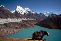 View of Gokyo Lakes
Yes. Many camping areas. There may be a small fee from the land owners. There are huts as well as small tea houses where you can sleep with hundreds of other trekkers. A tent here can be usefull as while the company and conversation can be interesting it can continue all night so if you wish fresh air, santuary and sleep... bring a tent. If you are continuing on to Everest Base Camp it is a must anyways.
Mountain Conditions
 On the route in to Gokyo Ri in 1986.
October to end of November are the most popular because of good visability. The monsoon has cleared the air of dust. January to end of March is the next most popular as it gets hazy near the end of March due to dust from the plains of India. You should be prepared for all types of weather. The evenings will be cold for sure but the daytime can be hot even at altitude. Rain, sleat, snow, heat and leaches
Helping the Sherpa community
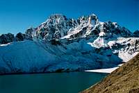 Gokyo region
There are several organizations dedicated to helping the Sherpa community. Here are just two. Should you wish to contribute to this worthwhile cause contact either of the following organizations though the information below. The Sir Edmond Hillary Foundation 222 Jarvis Street Toronto, Ontario, Canada M5B 2B8 (416) 941-3315
The American Himalayan Foundation The American Himalayan Foundation 909 Montgomery Street, suite 400 San Francisco CA 94133 Telephone (415) 288-7245 Fax (415) 434-3130
What to bring
Partial Equipment list info: Here is a brief incomplete list for you. Minus the Climbing gear
- 6-pairs socks
- 6-underwear
- 2-pairs of shorts for the walk in
- 3-T-shirts for the walk in
- 2-bandanas or a sun hat to keep off the sun
- Sunscreen, sunscreen, sunscreen plus zinc
- Good sturdy hiking shoes
- 1-sleeping bag (as warm as you can get)
- 1-sleeping pad (your choice the more comfortable you are the better you sleep the more energy you will have) you can get a Crazy Creek chair that goes with your pad this is a good investment.
- 2-expedition weight Patagonia long underwear tops (or 1 depends on how dirty you like to be)
- 1-expedition weight Patagonia long underwear bottom
- 1 lightweight fleece bottom
- 1-heavy weight Patagonia or similar fleece jacket
- 1-Gortex shell jacket
- 1-Gortex shell pants (full length zippers)
- 1-Down filled jacket liner from Feathered Friends of Seattle, (optional but I always end up using it)
- 1-Downfilled Gortex guides Parka 1-Warm hat with ear flaps
- 2-pairs of heavy duty mittens (in case you lose one pair up high)
- 1-pair fleece gloves 1-pair ski gloves
- 1-pair of Koflach double plastic boots, One Sport (warmer)($$$) or Asolo (I prefer Koflach, I find them more comfortable)
- 1-pair of gaitors
- 1-pair ski poles
- 1-ice axe
- 1-pair of sharp crampons (test them on your boots before you leave and make sure they fit perfectly)
- 1-headlamp with extra batteries and bulbs
- 1-cup with spoon attached
- 1-Swissarmy knife
- 1- stove of your choice (I use Markhill stormy hanging stone with Blueway cartridges, you can get fuel in Kathmandu as it is difficult to fly down). You can also get white gaz.
- 1-tent
- 3-1-litre waterbottles each (drink at least 5 litres a day to help acclimitise)
- Camera and film (tripod and filters)
![]()
![]()
![]()
Political situation
Would welcome comments and updates on how things are on route.


Damien Gildea - Aug 23, 2006 2:40 pm - Hasn't voted
edEdmund Hillary, not Edmond :-)
William Marler - Aug 24, 2006 2:08 pm - Hasn't voted
Re: edThanks (•:
Damien Gildea - Aug 26, 2006 1:17 am - Hasn't voted
edsI see you have it in Pumori as well. Maybe in all your Khumbu stuff ? Anyway, a minor point. I've enjoyed all your pics and info. Thanks for the effort. thanks, D
William Marler - Aug 26, 2006 11:56 pm - Hasn't voted
Re: edsill do a review. Its time for it anyways. Thanks again.
DDvO - Nov 28, 2008 6:22 am - Hasn't voted
altitude differentiation, alternative name, political situationThe elevation you give, 5483 m, pertains to the second summit which is not usually climbed by trekkers. The first, easily reached summit is only 5357 m high but offers similarly good views. A common (and more genuine) alternative name is Gokyo Ri. See also http://en.wikipedia.org/wiki/Gokyo_Ri The information in the "Political situation" section is meanwhile obsolete and should be removed to avoid confusion.
William Marler - Nov 28, 2008 4:13 pm - Hasn't voted
Re: altitude differentiation and alternative nameThanks. and cheers William
gimpilator - Dec 4, 2012 3:35 pm - Hasn't voted
CoordinatesHere are the coordinates so that this page will be linked to the map along with the other peaks of the region. 27.961305, 86.683055