Getting There
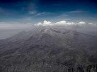
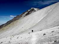
![The Road Between Chachani and Misti]() The Road Between Chachani and Misti
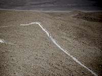
The Road Between Chachani and Misti![If You See This, You re On the Right Road]() If You See This, You're On the Right Road
If You See This, You're On the Right Road
This trip report is part of a climbing trip that we did at the end of 2007. The full report on that is called "Seven Summits – Arequipa, Peru", and can be found
here.
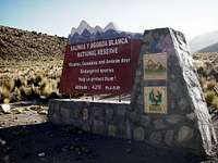
I was really looking forward to climbing Chachani, as it was a new 6,000-meter mountain for me. When Nathan and I had done a training hike on a low knob on the side of it, we had met a driver who takes climbers to the trailheads, and he had given us the driving instructions. There are two ways to reach the trailhead (La Azufrera Route); one is the rough gravel road between Misti and Chachani, and the other is to take the paved highway that goes towards Chivay and Colca Canyon. The paved road is quite a bit longer, and just beyond passing a toll booth you need to turn right on a gravel road that take you around the backside of Chachani. If you are taking the old gravel road between Misti and Chachani, after climbing up past the two mountains, you come to a "Y", the right fork takes you to the trailhead on the backside of Misti and the left fork takes you behind Chachani. Both routes take about the same time; it's a matter of comfort verses cheaper (less fuel and no toll). Coming from either direction, take the only road that heads towards Chachani. It's not much of a road, just a jeep trail that winds its way up towards the mountain. Shortly after turning on the jeep trail, there is "Reserva Nacional Salinas y Aguada Blanca" sign. Shortly after that, you will pass another "Salinas y Aguada Blanca National Reserve" sign, this one is in English, at 4210 meters. The one at the Misti trailhead is about 400 feet higher than the posted 3415 meters; I don't remember checking the accuracy of the sign behind Chachani.
Base Camp
![National Reserve Sign]() National Reserve Sign
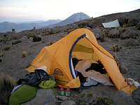
National Reserve Sign![Our Base Camp On Chachani]() Our Base Camp On Chachani
Our Base Camp On Chachani
This area is a protected vicuña, guanaco and Andean deer reserve, we did see quite a few vicuñas, but not the others. The road gets increasingly rough, with lots of loose sand; I would not try it without four-wheel drive. At one point you have the option of going more or less in the direction of Chachani, or turning to the right. I recommend going to the right, which is a less steep climb. The other one might be OK for the downhill return, but we didn't use it. We again had Lucho go with us to take the car back and meet us the following day, however the trailhead is so remote and hard to get to that I don’t think there would be any problem leaving a vehicle unattended there during the climb. At 5:30 pm we reached a fairly level area at 15,990 feet and set up camp there. The road does continue on up, but we didn't want to sleep any higher than that as Smiley was concerned about his lack of acclimatizing, especially for sleeping.
To the Summit
![Official Base Camp]() Official Base Camp
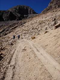
Official Base Camp![Hiking Up the Road]() Hiking Up the Road
Hiking Up the Road![The Traverse After the Pass]() The Traverse After the Pass
The Traverse After the Pass![Nearing the Final Summit Climb]() Nearing the Final Summit Climb
Nearing the Final Summit Climb![On the Summit of Chachani]() On the Summit
On the Summit
In the morning, we decided to pack up our tents and hide them and other unnecessary gear behind some rocks a little ways away, and started climbing at 6:35. A half hour later we reached another National Reserve sign, this one said "Nevado Chachani Base Camp" in English. It showed 4855 meters (15,924 feet) but our GPS and altimeters were around 16,600 feet. All of the signs seemed to be off on the elevation, and most of them had the elevation numbers partially scratched out. At 8:05 we saw some rock wall campsites at 17,400 feet. A mining road used to continue up to here, but it hasn't been maintained and it became impassable even for 4x4s about 15 minutes below the campsites.
From here it is best to climb up in a sandy gully to a saddle, there is a trail there that we didn't see until we were going back down. We were trying to follow the old road up but the trail ran out and we had to take a rough trail-less traverse over to the gully. At 9:30 we reached the saddle, and from there the trail drops down some to traverse around a lower peak on the way to the summit. Some of the trip reports mention snow here, and the need for crampons due to the steep slope, but there was no snow when we did it in December. There were a few small patches of snow farther on up near the summit; but it was mostly just a meandering sandy trail, with lots of ups and downs until we reached the top. We got there at 12:20 in bright sun and a cold wind. The summit is marked by a small rebar cross, and great views, including neighboring El Misti and farther away, Ampato and Coropuna, both of which were beckoning us.
![Yeah, Here Comes the Van]() Yeah, Here Comes the Van
Yeah, Here Comes the Van![El Misti In the Clouds]() El Misti In the clouds
El Misti In the cloudsAfter 35 minutes on the summit, we headed back down. Nathan, being young and full of energy, wanted to bag the summit of Cerro Nocarani (18,980') on the way down but didn't get any other takers so decided not to do it alone. At 17,800 feet we saw a high camp in some gray gravel, which we hadn't seen on the way up. We reached the top sign at 3:15 and were back at our camp at 3:50 pm for a total time of 9 hours and 15 minutes. Many people who climb these mountains are not in shape, nor acclimatized. However because they are technically easy (Chachani is supposed to be one of the easiest 6,000 meter peaks in the world), many people want to try climbing them. Hence, there are an abundance of camps for those who need to take two or three days to acclimatize during the climb.
Lucho hadn't arrived yet when we got back to where we had camped so we picked up our stashed gear and repacked our packs. After waiting for a little while, I wanted to start hiking down the road to see if he was coming up. It was also getting chilly sitting still, and I don't sit still well anyway. I soon heard Lucho on the radio, he had just turned off the "main" road and was on the jeep trail climbing up to us. The sun was setting behind the mountain by the time we were heading down, but we got a few pics including El Misti in the clouds behind us. We decided to return to Arequipa on the Colca Highway, which was very busy with trucks and buses coming towards us on the way to Colca. You really need to be carefull when you pass because they don't turn their lights on until it is almost dark, and they pass on curves and hills! However we made it safely back to Arequipa for a good night's sleep - tomorrow we drive to Ampato!
Comments
No comments posted yet.