Of the 20 most technically difficult county highpoints in the contiguous United States, also known as “Apex” county highpoints, seven are located in Washington. Of those seven peaks, I was fortunate enough to have summited two of the most technically difficult, Mount Olympus and Bonanza Peak, at the beginning of July. After those trips were completed I only required summiting two more peaks, Big Horn and Mount Baker, to complete the Washington County Highpoints.
Of those two peaks, Big Horn is considered to be much more technically difficult than Mount Baker. In fact, many people consider the “crux” move near the summit of Big Horn to be the most difficult crux move of any county highpoint in the contiguous United States. I knew that Big Horn would likely be my last big obstacle before completing the Washington County Highpoints list.
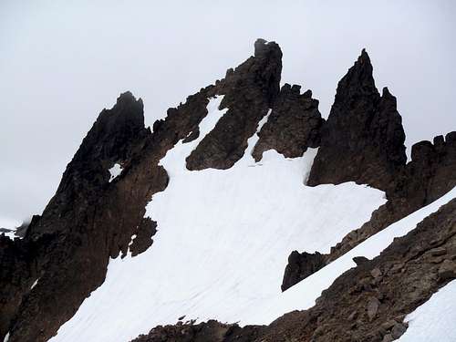
Big Horn Looms Above Cispus Basin
I began seriously considering an attempt of Big Horn starting the previous year. My biggest concern was not the peak itself but rather who I would make an attempt with. Due to my own inability to lead rock climbs at this stage, I immediately knew that I would need to find a competent rope leader who would be comfortable in that role. However, most of my county highpointer friends had already summited the peak and I was not aware of any person willing to summit the peak twice. Knowing that few people outside of county highpointers attempt Big Horn, I began wondering if finding the right team for a successful summit attempt might be more challenging than actually summiting the peak itself.
If I was to be a part of any potential summit team for Big Horn I wanted to make certain that I would be with the right people for such an endeavor. The people would need a variety of mountaineering experience and skills, and perhaps more importantly would need to be people who I could completely trust to be with on such a technical peak.
The Horns Of Goat Rocks (Big Horn In Center)
As luck would have it, I was invited to join a potential summit party. The group was to consist of several mountaineers: Adam Helman (who for the remainder of this trip report will be referred to only as Adam), Greg Slayden, Adam Walker (who for the remainder of this trip report will be referred to only as Gimpilator), Eric Noel, and I. Adam needed Big Horn as part of his quest to summit each of the county highpoints in the western United States. Greg had summited Big Horn during early July 2007 despite suffering from an accident during the ascent, and was surprisingly willing to go back one more time (which virtually nobody does with Big Horn) to lead our group. Moreover, because Adam had done much of the planning for their successful mountaineering trip in South America earlier during the year, Greg wanted to help return the favor to him. Gimpilator was not a county highpointer and had little knowledge of Big Horn outside of what I had mentioned to him on several occasions, but he had always wanted to visit the Goat Rock Wilderness Area where Big Horn is located. Eric unexpectedly backed-out of the team several days prior to trip due to other commitments, and after his departure we kept the team small and intact to enhance our chances for success.
I wanted to optimize our chances for success by driving to the trailhead on Friday evening, but that was not the consensus. We would each be carrying heavy backpacks, which would be especially more difficult for Adam to do considering his small size (5' 7", 110 lbs). Plus, Greg worked on Friday, so it was decided that Saturday would be our low-key, non-technical day. We planned to start hiking midday on Saturday, find a decent campsite area in Cispus Basin that afternoon, and then make a summit attempt on Sunday. That plan did not allow room for error in case of bad weather on Sunday, but we were fortunate to have a weather forecast that looked good.
DAY ONE: Greetings And The March To Cispus
I picked up Gimpilator and Greg on Saturday morning, July 30. We drove over three hours to reach the Snowgrass Flats Hiker Trailhead #96A (~4650’ elevation). Adam was waiting at the trailhead for our arrival. This was my first time meeting Adam, and I quickly discovered he has a vast knowledge of peaks in general and county highpoints specifically. After our various introductions and gear sorting, we began hiking at 11:35 AM.
The weather was very good and there was no snow along the lower section of the trail. We encountered occasional minor patches of snow prior to the bridge crossing Goat Creek, but nothing significant. After Goat Creek, the snow became more frequent. At one point, the snow covered over the trail so much that we lost the trail route altogether. Greg and I each had GPS devices that showed our intended direction straight ahead, although we later discovered during our descent that the trail system actually switchbacked along a hillside to the west of where we had lost the trail route. Greg and I had the team continue straight along snowy terrain towards where our GPS devices showed the trail reaching a creek crossing.
It was during this part of our route that I began to realize just how much Adam hated trekking with snow. Considering Adam lived in southern California, I could understand why he might have some uncomfortability with hiking across snowy terrain. However, considering Adam had summited all but 11 county highpoints in the western United States, including some of the snowiest and most technical county highpoints, I was shocked to see him express such discomfort just hiking along snow, which was not at all steep terrain. He claimed this discomfort resulted from what he considered "a perfect storm" which he had never previously encountered all at once: a heavy backpack (which nearly equalled half his body weight), side-traversing along hilly terrain, and slushy snow. With that said, he was determined to continue and we maintained a good pace.
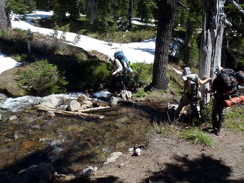
At 1:35 PM we reached major creek crossing at the same location that the actual trail crossed it. Without a bridge present, we had to ford the creek using rock-hopping techniques. We each took several minutes to examine the various options. Greg, Gimpilator, and I were comfortable with one particular section to cross, while Adam found a section further upstream that he thought looked easier to cross.
Fording A Creek
Once on the other side of the creek, a wooden sign pointed our team in the correct direction, and although there was continuous snowpack to traverse, the route was relatively straightforward to follow. Within an hour, we reached a junction with the Pacific Crest Trail (PCT) and decided to take a break there.
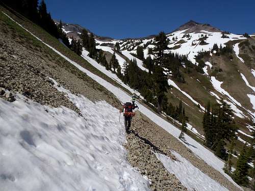
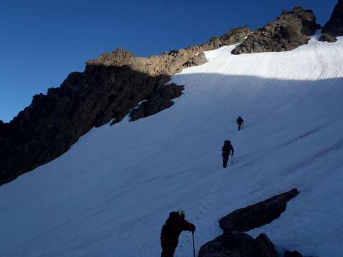
Despite the snowpack, we could see and follow several bootprint tracks along the PCT. Where tracks were not present, we could still trace the PCT route fairly simply. The route soon began side-traversing along snowy slopes, which increased Adam's dissatisfaction with the terrain conditions. We eventually reached open talus slopes followed by meadow slopes, prior to reaching Cispus Basin. These slopes had more exposure to direct sunlight than the rest of our earlier route, and there were numerous sections already melted-out as a result. Small streams passed across the trail under multiple snowy sections, for which we used extra caution crossing. One decent-size waterfall crossing was required, but still nothing trivial.
Side-Traverse On PCT
Approaching Cispus Basin
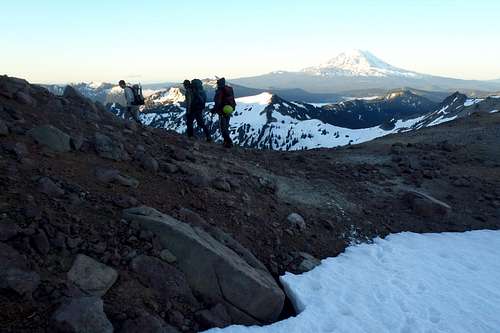
We finally reached our camp (~6150’ elevation) at Cispus Basin at 4:05 PM, exactly 7.5 miles and 4h30m from the trailhead. Shortly after reaching camp, I looked slightly northeast towards our next day’s goal of Big Horn. While looking up the basin I saw a lot of movement along the snow at the base of the rocky ridgeline near the peak. I quickly realized that the movement was a large herd of mountain goats trekking across the upper basin. In total, I counted nearly four dozen mountain goats, far exceeding any herd total I had ever previously seen. After watching the goats for a while, we spent the remaining daylight hours setting up our tents, resting, making dinner, and preparing our gear for the following day… our summit day.
Cispus Basin
Nearly Four Dozen Mountain Goats!
Big Horn At Sunset
DAY TWO: Great Team, Good Snow, Bad Rock, And Worthy Summit
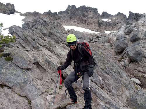
The following morning, July 31, our team began leaving camp at 5:35 AM. We reached a mountain pass (~6900’ elevation) at 6:10 AM. The pass has no official name, although Greg dubbed it “Black Thumb Pass” due to its close proximity to a rock spire nicknamed “Black Thumb”. There was a lot of evidence of previous mountain goat activity at the pass, especially where they had rested and left tuffs of hair on the ground. Our group put on our helmets (although my helmet was already on when I had left camp) and crampons (except Gimpilator). Then we continued heading east over the pass.
Summit Day Begins!
"Black Thumb Pass"
We passed by two steep snow gullies before reaching a gully located immediately prior to a stream gully. We ascended the steep snow slope for ~100’ before Adam found a rock rib to scramble for a while. Gimpilator did the same. Greg and I continued on the snow because it seemed safer, more straightforward, and less labor-intensive. Eventually, the rock rib ended at a large rock-snow moat, forcing Adam and Gimpilator to follow the snowy route being ascended by Greg and I. However, as soon as another rock rib was reached higher up, at ~7300’ elevation, Adam and Gimpilator once again left the snow in favor of a loose rocky scramble. We soon each crossed a short snow slope to a boulder rock outcrop (~7550’ elevation) at 7:30 AM, where we took a 15-minute break.
From the boulder outcrop, we could see the rest of our summit approach route. After crossing a steep snow slope, we would reach a steep rock rib that we would scramble for most of the remaining ascent. The upper snow slope that we were about to side-traverse to the rock rib was the same area that Greg sustained a fall during his previous trip to Big Horn during 2007. He showed our team where he had fallen and described how it had happened. Fortunately, our team was able to cross the snowy slope and reach the rock rib safely at 7600’ elevation.
Crossing The Last Steep Snow Slope...
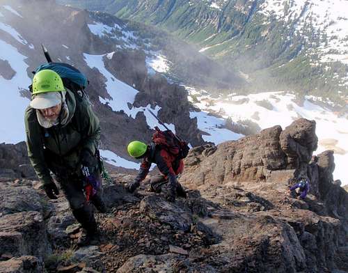
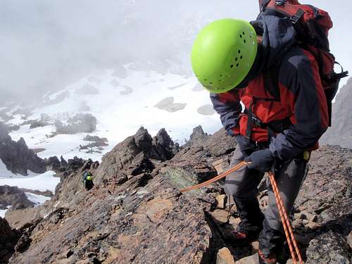
Adam and Gimpilator were both ecstatic at the prospect of leaving snow a final time for our ascent. After removing our crampons, we began steeply scrambling the rock rib. Due to several steep sections on the leftside and middle sections, we primarily scrambled on the rightside of the rock rib. There was no “wrong” route; we just kept trying to find the path of least resistance and that seemed to work well for us. We finally reached the “crux” section (~7960’ elevation) of our trip, a short but steep rock climb, at 8:45 AM.
Greg, Gimpilator, and Adam Scrambling A Rock Rib...
Redwic and Adam Scrambling Steep Rock...
Scrambling High On Big Horn...
Gimpilator Sees The "Crux" Section
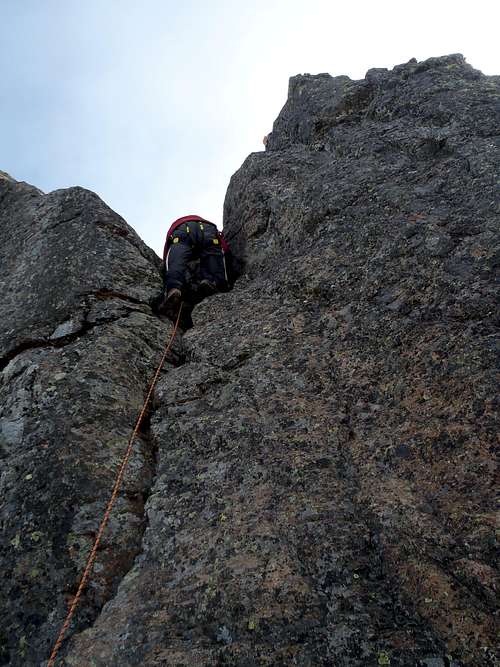
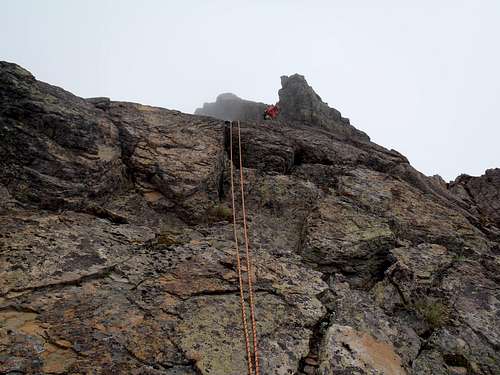
As mentioned earlier, the “crux” move of this section is considered by many people to be the most difficult crux move of any county highpoint in the contiguous United States. Famous local peakbagger Fred Beckey lists this crux move as YDS Class 4, but most people categorize it as being in the YDS Class 5.4-5.6 range. The “crux” section involves ascending a 10’-15’ crack, which would be the shortest rock climbing pitch that Gimpilator and I had ascended during our various trips during that month. Greg setup the rope and led this section, followed by Gimpilator, Adam, and finally me. This took some time, but we were trying to be as safe as possible. I tend to agree with the YDS Class 5.4 rating for this section; there was only one spot in the middle of the rockface that required extra time to ascend, but only slightly so. Once atop the “crux” section, the rest of the ascent was an easy ridge walk (~30’) to the summit (8000’ elevation), which we reached at 9:25 AM.
Gimpilator Climbing The "Crux" Section
Looking Up At The Summit Of Big Horn
Reaching the top of Big Horn was quite an achievement for each of us. For Greg, it was his second successful summit of the peak. For Adam, it was his 35th Washington County Highpoint achieved and then only had 10 county highpoints in the western United States still to summit. For Gimpilator, it was his first summit attained in the Goat Rocks Wilderness Area, and he enjoyed the ascent so much that he immediately wanted to attempt more peaks in the region. For me, it was my 38th Washington County Highpoint achieved, leaving only Mount Baker (located in Whatcom County) to complete that peakbagging list. I did not think the summit approach, overall, was more difficult than Mount Olympus or Bonanza Peak. However, due to the steep snow slopes, loose rocky slopes, scrambling, and rock climbing involved, I could easily determine why Big Horn deserves its “Apex” status as one of the more difficult county highpoints to summit.
Happy To Have One Less Summit To Climb
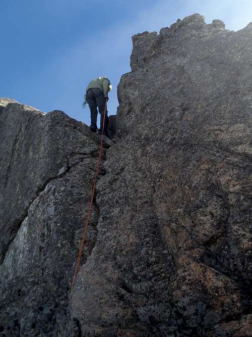
After taking a break along the summit ridge, we rappeled down the “crux” section and then chose to rappel most of the rock rib rather than downclimb it. Doing so required more time but also seemed safer than downclimbing. The rappeling made us feel much more comfortable, although Gimpilator and I briefly considered steeply descending the snow slope located on the side of the rock rib. After reaching the bottom of the rock rib, we each crossed the steep snowy slopes back to the boulder outcrop at 12:15 PM.
Greg Rappels The "Crux" Section
Greg Leads The Second Rappel...
Adam Begins The Second Rappel...
Gimpilator Begins The Second Rappel...
After taking a 15-minute break there, Greg, Gimpilator, and I began trekking towards Gilbert Peak while Adam decided to stay at the boulder outcrop and rest. We did not reach Gilbert Peak only due to time constraints that day, only getting as far as the upper slopes of Goat Citadel, and we returned to Adam at 2:15 PM.
Adam did not like the prospect of descending steep snow slopes, so we sought a better descent option elsewhere. We found a rock rib located near the gully we had ascended. There were several cairns on the rock rib, which gave us confidence that we were on a viable route. The rock rib led our team down the other side of the stream gully that we had avoided on our ascent, forcing us to steeply descend to, and then cross, the stream. After traversing over one final short rock rib on the other side of the stream, we plunge-stepped and glissaded down the remaining 100’ to the basin below.
Adam Descends A Loose Rocky Rib
I reached “Black Thumb Pass” at 4:10 PM, with the rest of the team a short distance behind me, and then we reached camp at 4:35 PM. After taking a break, gathering water, and tearing-down our campsite, we headed back onto the PCT shortly after 6:00 PM. The descent to the trailhead was mostly uneventful except for reaching our vehicles at 9:40 PM in the dark. Greg, Gimpilator, and I said our “good-byes” to Adam before heading back home at 10:00 PM. Adam, on the other hand, decided to car-camp that evening before heading to Idaho to attempt more county highpoints on his “to do” list. I finally reached my home at 1:50 AM on Monday morning, very tired but very happy to be home safe after a successful trip for Big Horn.
TRIP VIDEO
SPECIAL THANKS
Special thanks to Greg Slayden for making this trip possible. His prior knowledge of the route and terrain, combined with his rope-leading skills, really benefited our team. Thanks also to the two Adams, Mr. Helman and Mr. Walker, who were great mountaineering partners and who provided great conversations throughout the trip.
Thanks for sharing this. I have very little experience of mountains in the US - looks like all the pleasures of the really big mountains, in terms of remoteness, approach etc but without the altitude!
Parents refers to a larger category under which an object falls. For example, theAconcagua mountain page has the 'Aconcagua Group' and the 'Seven Summits' asparents and is a parent itself to many routes, photos, and Trip Reports.


Comments
Post a Comment