
|
|
Route |
|---|---|
|
|
46.44779°N / 13.83385°E |
|
|
Hiking, Mountaineering, Scrambling |
|
|
Summer, Fall |
|
|
A long day |
|
|
Easy climb UIAA II and scrambling |
|
|
Approach
The trailhead starts in Vrata valley, on the meadow, called Poldov rovt (940m).Route Description
From Poldov rovt you take the west direction. Soon behind the meadow you will find a good hunters path, ascending through woods a bit more than 100 meters. Reaching the area (the edge) of a distinctive ravine Rdeci potok (= Red Creek, it has usually no water) you proceed by it's bottom and by no means follow another hunters path, turning towards NE. Through the shallow valley of Rdeci potok you climb in a NW direction, you can easily follow the path. So you reach the vertical rock barrier over which usually a nice, but weak waterfall is falling. The path leads you by the right side, you climb over a few rocks and cross the slope, reaching just on the upper edge of the waterfall. This is such a beautiful place, that everyone can only hardly resist to take a rest.Above the waterfall you ascend directly upwards by the long tongue of debris, which you will probably use on a descent. First you go by the right edge, then you cross on the left side and proceed through a beautiful larch area. Reaching out of it you will notice in front of you a sharp peak of Mali Matterhorn (1962 m, just a 100 meters high rock). You ascend yust to the foothills of it (a big cave) and then proceed to the right over scree. On the right side you have all the time fine debris below Splevta. This is the longest scree in Julian Alps and also the finest one. On a descent you will have a comfortable drive down for more than 500 meters (which can take you only 10-15 minutes)!!!
Proceeding by the left side of scree you climb grassy and rocky slopes and reach the Bivouac II (2118m, 3 hours).
From the bivouac you go in direction N to the Grlo pass. You climb (UIAA I) and scramble the small steep slope and you are on Grlo pass.
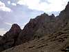
On the right (on the E side) is ridge to the Dovski kriz and on the left (on the W side) the ridge to the Veliki Oltar. First you scramble after the small scree then you come to the ravine and on the left side you climb to the top of Veliki Oltar. You climb UIAA II some meters but it is not very hard. You must be careful because the rock here is not soo good.
You descend by the same route back. The screes in middle part make you descent very easier. You must take care that you stop before waterfall. =)
 |  |  |