
-
 6373 Hits
-
 72.08% Score
-
 2 Votes
|
|
Route |
|---|---|
|
|
46.43918°N / 13.83023°E |
|
|
Mountaineering, Scrambling |
|
|
Summer, Fall |
|
|
A long day |
|
|
Class 4 |
|
|
UIAA II |
|
|
Overall grading (by hiking standards)
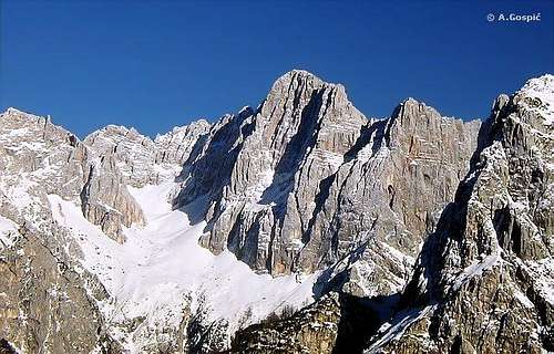
On Saša's beautiful picture on the right, the screes (snowfields) below Škrlatica are seen, the pillar of Velika Ponca (mountain on the left) and Veliki Oltar - the summit next to it.
- 0. General: from 1218 m (hut in Krnica) to 2621 m (summit), exposition W, not marked (only partially weak trails) rock climb. On the Swiss Hiking Scale the overal grade woukld be T6.
- 1. Effort: 1400 m of elevation gain, 4 h 30 min for ascent only,
- 2. Power: 4 - demanding,
- 3. Psyche: 4 - demanding,
- 4. Orientation: 4 - difficult.
Essential Gear
Good shoes, poles, a short rope, a helmet.
Approach

Velika Dnina
The tour on Oltar from the west starts at Bivouac I (in Velika Dnina), 2180 m, which is also the starting point for many other tours on the surrounding mountains. So, let me first describe how to reach the bivouac. The long wall, which Škrlatica and the neighbouring mountains show towards the west (beautifully seen from Vršič pass), ends on the northern side in the Velika Dnina basin. So, the bivouac there can be reached from Krnica valley (see the approach to the Krnica hut on the main page).
From the mountain hut in Krnica, 1218 m, we go by the marked path towards the east, as for the normal approach on Špik from the south. The marked path first goes by the long ravine, called Gruntovnica (actually coming from the Špikova škrbina). Where the marked path for Špik turns left out of the ravine, we continue (not marked) by the ravine, till it splits, or actually divides in many smaller. There we turn ringt, where it's most easy, and ascend steeply over grass and terraces, all the time towards the right. Although it is not marked, we can follow a tiny path. When we reach a steep, rocky ravine, we use it to go straight uphills, climbing over a few easy steps and finally exiting on broad screes under the north face of Škrlatica. From there on we cross the screes on their bottom part towards the left, orienting ourselves on the lowest rocks of Velika Ponca pillar. There's the bivouac. But it is hanged some 50 meters above the bottom of rocks, so we must ascend screes on the right and use a narrow ledge to reach the bivouac. From Krnica hut 2 h 30 min.
Route Description
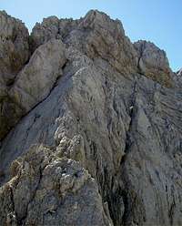
On the summit ridge
From the Bivouac I we continue the ascent right of Velika Ponca rocks, always over screes till their upper part. We shall enter an open rock face, not hard for climbing, which is falling from the notch between Velika Ponca (on the left) and Oltar (on the right). We continue over easy rocks and soon discover that we can best advance by a narrow ravine. When it gets closed, we seek for a passage on the right side of the rock (or over the rock - there's a peg on top of it) and continue above the barrier over easy rocks towards the notch. One more narrow ledge on the northern side of a rocky barrier and we reach the notch. Till here, you can also reach from the north, from Martuljek, over the Kačji jezik ravine (Snake tongue - usually snowfield).
From the notch towards the summit of Veliki Oltar a ridge leads, which has only one bad point - it is too short! Climbing by it is so beautiful and joyfull, never harder than UIAA I degree, open on both sides and it hits the summit itself. From the Bivouac I to the summit you'll need less than 2 hours.
Descent: By the same route, unless you have two cars or any other means of transport in the valley of Vrata or in Martuljek.