
-
 30235 Hits
-
 91.14% Score
-
 34 Votes
|
|
Route |
|---|---|
|
|
0.03159°S / 37.31369°E |
|
|
Mountaineering |
|
|
Fall |
|
|
One to two days |
|
|
5.8 (YDS) |
|
|
D |
|
|
20 |
|
|
V |
|
|
Overview
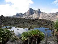
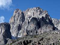
Nice and airy climbing on the second highest peak of the continent with fantastic surroundings and stunning scenery.
This route is the normal route of the NE face of Batian and the summer and fall seasons.
The other side of the mountain is unclimbing in this seasons, because of this part is totally snowy. In winter - the Northern hemisphere - the climbing conditions is the reverse.
The rock is mainly solid granit, but there are some pithes where are loose rocks.
The route lies on the NE side of the main peak. The climbing is "alpine" with 5th class and easier climbing. The route starts in a rocky couloir for about 7 pitches, then traverses left into the Amphitheater, a lower angled section at mid-height. Above this, theres is the Firmin's tower, normally the crux of the climb. Steeper climbing up cracks and chimneys leads to the top of the tower. This part is usually icy and snowy, so this might be quite difficult.After the Tower there's a few pitch of easier section, and one more difficult pitch to the juncture - Shipton's Notch - with the West Ridge. From the Shipton's Notch the ridge crest follow to the summit, with some tricky sections.
Descent is mostly along back the route of ascent, with a few time-saving variations.
DON'T descent on the south side of the mountain, than others suggest it.
Getting There
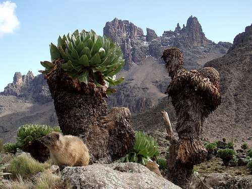
The main peak lies in the middle of the mountain. The base camp is lies at 4240 m. bottom of the peaks. You can reach the camp in 2-3 days depends on the starting town and route. The most common route is start from Naro Moru town. From here you can reach the camp about 3 days. You can see the most beautiful landscape on the way from Sirimon route to Chogoria route, or the way back. From Nanyuki town - starting point for the Sirimon route - to Shipton's camp the route take 2 days.
From Chogoria town - starting point for the Chogoria route - to the camp takes 2 or 3 days.
From Shipton's Camp follow the normal trail towards Point Lenana. At the first flat above camp (about 4500 m.), take the cairned R fork towards Batian. Follow cairns up the drainage. You walk up toward to the NE face of Batian. Before you reach the main wall almost the level of the base of the Krapf Glacier, you turn R. The start of the route is marked with a cross in a circle with blue paint. The way up 'till this point from Shipton's Camp take about 1 hour.
Starting times for the route are usually such that you arrive at the first pitch just before dawn.
Route Description
 |
 |
 |
 |
 |
 |
 |
Pitch 1.
Climb up from the cross in circle on good rock. At 20 meters a move right (R) leads to a ledge. Continue R on ledge for 2 meters and belay off horn. 20 meters, (IV.)
Pitch 2.
Climb cracks up and continue up ledges and short easy steps for 20 meters. The belay at rappel anchor. 15-20 m. (III.) Pitches 1 and 2 can be combined.
Pitch 3.
From the belay, walk Left (L) and, you arrive the main gully, where you Shorten rope and move together for 60 meters up gully, than climb R and Up to the rappel anchor on the R side of the gully 10-15m. (SCrambling and III.) It divides for 2 pitches.
Pitch 4.
Climb and L and back to the center of the main gully. Passed the rappel anchor with old ropes on a deteched rock below the corner. Enter the corner above and climb to its top. Belay at rappel anchor above. 40-45 m. (IV+-V)
Pitch 5.
Climb L side of easy slab above. Passed the 2 pitons below steepening wall, then climb up and R on steep blocks, then corner to a large terrace with a rappel anchor on block. Belay here. 40-45 m. (III, IV)
Pitch 6.
Continue up and L on large ledges to the base of a chimney. Climb up in the L face chimney, then traverse horizontally a bit L on the easy rock, under a steep orange wall for 4 m. 35-40 m. (III, V+)
Pitch 7.
Continue up the steep but easy blocky terrain while you cross the small ridge to the L at the cairn to enter the lower R edge of the Amphitheater 30 m. (II)
Shorten the rope and climb together for about 60 meters up the R edge of the Amphitheater to the highest and best bivy ledges, just under a low angled slab. Scrambling diagonally then belay the huge deteched block with fixed blue rope on the R. side of the Amphitheater (Sc)
Pitch 8.
Climb up and R into the gully. Belay the L face of a gully on a little terrace near the top of the huge west face (There’s no fixed anchor) 20 m. (III)
Pitch 9.
Round the huge blocks on the R ridge then turn L, and the belay on in the L face of a gully ( 2 pitons and ropes) 15-20 m. (II-III)
Pitch 10.
Continue to up and diagonally R. on the right side of the Firmin’s Tower, above the huge west face. The rappel anchor is 35-40 m. THIS PART OF THE ROUTE IS USUALLY ICY, so it might be quite slippery and difficult. (IV-V)
Pitch 11.
Continue up in the corner. The rappel anchor marked with old ropes, near the top of the Firmin's Tower in the ridge. 20-25m. (III)
Pitch 12.
Continue up the crest of the ridge on the little broken rocky terrain. The ridge becomes steeper and you arrive the Knife Edge. On the begining of the edge there’s a rappel anchor. 25-30 m. (II)
Pitch 13.
Continue the climbing on the Knife Edge ’till the steep yellow wall. Climb steeply up and R on blocks and cracks. THIS PITCH OFTEN ICY AND SNOWY. Pass piton and belay at slings on rappel horn. 45-50m, (V-V+).
Pitch 14.
From the belay climb up and diagonally R. on the cracks. THIS PART OF THE PITCH ALSO USUALLY ICY. 15-20. m later you traverse R horizontally for 5 meters on a little bivy place. The belay is near the bivy. 25m. (V)
Pitch 15.
From the bivy place you climb up ont he ledges with loose rocks. For 20-25m later you turn L. in the huge ledge below the West Ridge. You passed another good bivy place and go towards 55m. (II, Sc)
Pitch 16.
Climb 5 m. up on the ledge then follow the traverse on the ledge Leftwards. While you at the begining of the Shipton’s Notch you belay. There’s no fixed Belay. 55 m. (I-II)
Pitch 17.
A short 5 meter exposed traverse to the L leads into Shipton's Notch. (V.)
From Shipton's Notch climb steeply up on crest for 15 meters to rappel webbing above. THIS PART IS OFTEN ICY. 30 m. (V)
Pitch 18.
Follow the ridge crest, weaving in and out of rock towers. There’s another exposed traverse on the L side of the ridge. Then belay on the top of a huge tower. 40 m. (IV)
Pitch 19.
Continue climbing ont he ridge crest, across to the funny horizontally corner. Then a ledges system you turn R. bellow the main summit block. Belay here below the steep blocks (there’s no fixed belay) 40 m. (II+)
Pitch 20.
When within about 40 meters of the summit go little L on the, steep blocks and rocks, which are climbed up, back to the crest. Then another 15 meters of blocks to the R of the crest leads to easy ground. Belay here there are ropes. (III). The summit is about 10 meters away on the R side.
Essential Gear

alpine rock boots, eventually rock climbing shoes
helmet
double ropes (to manage 50 meter rappels)
Set of friends
few stoppers, medium to large
7-8 quick draws
single slings
External Links
Add External Links text here.