
|
|
Trailhead |
|---|---|
|
|
41.90000°N / 84.6°W |
|
|
Hillsdale |
|
|
Spring, Summer, Fall, Winter |
|
|
1150 ft / 351 m |
At Lost Nation State Game Area
For the Lost Nation State Game Area, parking areas are accessible from either M-34 or M-99: 20100522 1544 | NCT trailhead
 20100522 1545 | Parking area
 20100402 1026a | NCT trailhead
S Pittsford Road
This is the southeast end of the Lost Nation State Game Area. Go south from M-34 (Hudson Road) about 2 miles, there is a small parking area 0.1 miles north of the trailhead and Losey Road - see pictures 20100522 1544 and 1545.
Skuse Road
This is near the center of the southeast section of the Game Area. There is parking for a few cars where the NCT crosses Skuse Road. Go south about 1.5 miles from M-34 (Hudson Road) on S Pittsford Road and turn right onto Skuse Road - no pictures at this time.
Gilbert Road
This is near the center of the Game Area, and both the southeast and northwest sections are accessible from here. Go east from M-99 (Pioneer Road) about 2.5 miles on Reading Road E, and 0.1 miles southeast on Gilbert Road is a parking area. Picture 20100402 1026a is the trailhead at the parking area for the southeast section. The northwest section trailhead is about 0.7 miles north at the corner of Reading and Rumsey Roads.
Way Road
This is not indicated on map MI-01. In the northwest section of the Game Area, this is parking for Lake Number Five access as well as the NCT. Go south from M-34 (Hudson Road) on Rumsey Road and turn right onto Way Road - the entrance is about 0.1 miles further.
Tripp Road
This is the center of the northwest section. Go south from M-34 (Hudson Road) about 0.5 miles.
Trail Road
This is also in the northwest section, further west from Tripp Road. Go south from M-34 (Hudson Road) on Bird Lake Road about 0.75 miles and turn left onto Trail Road. An unmarked trail leads directly east to the NCT.
Tote Road
This is not indicated on map MI-01. In the northwest section, this is a new parking area due to the re-routing of the NCT. Go south from M-34 (Hudson Road) on Tripp Road and take the first right onto Tote Road - go to the end.
M-34 (Hudson Road)
This is not indicated on map MI-01. This is the northwest end of the Lost Nation State Game Area, located about 0.25 miles east of Chase Road on the southern side of the highway.
Bird Lake Road
The parking area on Bird Lake Road can also be used, but it is now further away from the NCT than Trail Road.
Near Osseo
There is no obvious parking area at the point where the NCT is marked again at the start of the rail trail in Osseo, but you could park nearby along Blackbridge Road or another local street in the town. The trailhead can be reached by going north on Blackbridge Road from M-34 (Hudson Road).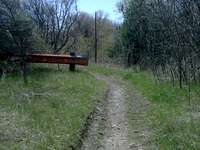 20100417 1416 | NCT trailhead, blaze on guardrail
For the Baw Beese Trail and in Hillsdale
For Hillsdale, all of the parking areas are to the north and east of M-99. 20100417 1428 | BBT S section trailhead, looking south
 20100417 1429 | Bicycle path, looking north
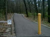 20100417 1442 | BBT N section trailhead, looking south
 20100417 1441 | Looking from BBT N section trailhead toward M-99
Sandy Beach
This is not indicated on map MI-01. In Hillsdale, there are parking areas at Sandy Beach - this is where the western end of the rail trail is located and near where the official Baw Beese Trail (BBT) (south section) has its southern terminus. The best route to Sandy Beach is east from local roads off M-99 (Hudson Road) south of Hillsdale (consult Google maps or Mapquest).
Barnard Street
There is a small parking area and trailhead for the northern terminus of the official BBT (south section) on Barnard Street where it crosses Griswold Street (refer to picture 20100417 1428). From there, a Hillsdale Rotary Club bike path continues through Hillsdale (refer to picture 20100417 1429), and there would be many opportunities to park along streets.
W Galloway Drive
At the end of W Galloway Drive, there are places to park along the street. This is where the southern terminus of the official BBT (north section) is located. Go west through Hillsdale College from Hillsdale Street to the end.
W Montgomery Street
At the end of W Montgomery Street there is parking for the northern terminus of the BBT (north section) (refer to pictures 20100417 1441 and 1442). However, the road is dirt, rough, and a decent slope - so I do not recommend driving here. However, to access this area, go west from Hillsdale Street north of Hillsdale College.
The best trailhead for the north section of the BBT is actually across the railroad tracks and bridge off of M-99 (W Carleton Road) - see next section.
Along the Hill-Jo Bicycle Park
Along M-99 (W Carleton Road) there is parking by Republic Waste Services. This is the southern end of the Hill-Jo Bicycle Park (as designated by the State of Michigan), but it is also the best access to the (new) north section of the BBT. 20100417 1450 | From M-99, looking down connector to BBT N section
There are many businesses to park at along the 3.7 mile length of the Bicycle Park, including the northern end in Jonesville.
After Jonesville, the NCT continues along road connectors to Litchfield.