
|
|
Route |
|---|---|
|
|
42.90640°N / 110.86098°W |
|
|
Hiking |
|
|
Summer |
|
|
Most of a day |
|
|
Moderate Hiking |
|
|
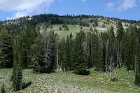
Overview
 Southwest View from Visser Peak
North Fork of Strawberry Creek Canyon provides the most straight-forward access to Visser Peak. This canyon is easily accessed from Star Valley, Wyoming near the town of Bedford. See the main peak page for directions. Anyone who ventures through this canyon will be inspired by the beauty and serenity of the area. Lush forests and meadows are commonplace. Wildlife is abundant and the air is clean. Best of all, you can have all this minus the crowds. This route can be done in one long day, or broken up into two or more. Either way, you will enjoy every minute of this route and will be planning future trips into the area. This is well worth your time.
Trailhead to Strawberry Lake: Almost 3.5 miles
Strawberry Lake to Visser Peak: About 1.0 miles
Trailhead Elevation: About 7000 feet
Visser Peak Elevation: 10,015 feet
Essentials
 The Meadow Dragon
1) The trailhead has no toilets
2) Strawberry Creek provides plenty of water at the trailhead and in the main canyon.
3) The North Fork is dry in the lower half of the canyon, but has plenty of water in the upper half.
 Cliffs Above the Lake
4) A large portion of the trail climbs through expansive meadows, so be prepared for the elements including rain and sun.
5) Sturdy hiking boots.
6) A map and compass and/or GPS.
Route Description
This is the approximate route:View Strawberry Creek Canyon in a larger map
From the trailhead to the lake:
 Canyon Overview
The route from Strawberry Creek Trailhead to Visser Peak is about as simple as they come. The trail begins by following the north bank above Strawberry Creek. The creek is fairly large and is crystal clear. As you follow the trail you will be looking for the North Fork canyon to open up on the north side of the main canyon. The trail comes to a junction where you will take a left to follow the trail that plunges in the north canyon. The trail is very distinct and would be hard to overlook.
In the north canyon, the trail begins in a forested area as you climb. But, before you log your first mile, the trees start to thin out and you will begin to see more meadows. This will be the scenery of the hike until you almost reach Strawberry Lake. The large portion of the canyon is meadow-like in the center, with stands of trees on the edges of the meadows. The meadow is filled with all kinds of flowers. You will have a constant view of Haystack Peak to your left. This peak is captivating. You will surely take a few snapshots of Haystack as you climb the canyon.
The canyon gradually bends around to an almost eastern direction. The hike will get steeper as you go. You will cross over to the east side of the stream as you ascend. The creek bed begins dry as you enter the canyon. But, the water eventually begins to flow and the higher you go, the more water you will find.
At about the three mile mark, you will find a little more forest and the stream will make a sharp turn to your right. The trail will follow right along the with the turn to the south. The trail is going to be a little steeper now as you climb up to where Strawberry Lake sits below Peak 9678. If you are planning on staying overnight, there are nice shady campsites on the east and west sides of the lake.
From the lake to the peak:
 Southwest Ridge
From the west side of Strawberry Lake, it is easy to see the ascent for Visser Peak. There is a rounded ridge, like an arm, that descends from the southwest side of the mountain. There is no trail from the lake to the summit. You will just have to do you own route-finding. This is simple enough. The slope is steep with shallow soil, which makes things slippery at times.
Once you reach the main ridge, you will only need to travel northward for a short distance. As soon as you reach the ridge, the view over the eastern face is stunning. Virginia Peak will be directly in front of you. The Wyoming Range will be seen just beyond the Greys River Valley. The ridge traverse is easy and fun. Eventually you will reach the summit where you will find a large cairn. There is no summit register on the top.
As always, the views are astounding, and rewarding.
 Salt River Peaks to the South