
|
|
Mountain/Rock |
|---|---|
|
|
42.94065°N / 110.81154°W |
|
|
Lincoln |
|
|
Hiking |
|
|
Summer |
|
|
10015 ft / 3053 m |
|
|
Overview
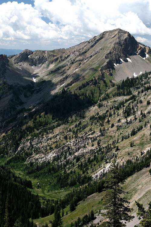
Nestled comfortably high in the Salt River Range, Visser Peak is a peak with a double personality. Visser Peak seems shy and unattractive from one perspective, but then appears daring and mighty from another. This seems to be a characteristic of many peaks in the neighborhood, and Visser Peak epitomizes this description. The western slope is steep but featureless, while the eastern side is scenic and prevailing. Either way, Visser Peak sits at an average height among its neighbors. The niche that Visser Peak occupies in the area is the centrality of its location. From the top of Visser Peak, grand vistas of all the high and attractive peaks can be found. Haystack Peak, Virginia Peak and Man Peak can all be viewed from Visser. Visser Peak can be considered a good "preview" peak for first-timers in the area who want to get a good look at the other peaks. And great looks is something Visser Peak has plenty to deal. The scenery in the area is glorious. Visser Peak will leave you drooling for more adventure and will make you dream of return-trips to come.Features
 Gorgeous Mountain Scenery
 Natural Lakes
 Wildflowers Galore!
When To Go
This area could receive visitors any time of year, depending on your activities. The best hiking is during the summer from June to September. The wildflowers are plentiful in late July-early August. Fishing in Greys River is good from June through Fall. Adverse weather can occur at any time.Getting There
Visser Peak is located in the Salt River Range, a part of the Greater-Yellowstone Ecosystem. The Salt River Range is located south of Jackson, Wyoming and is the range that forms the eastern panorama of Star Valley. Here is a resourceful link that provides all kinds of tourist information on the Star Valley and other neighboring areas.Star Valley:
 Small Cascade
Access to Star Valley is easy. Highway 89 runs the entire north-south length of the valley. Highway 89 provides a scenic drive from either direction. The south access will facilitate travelers from Southern Idaho and Northern Utah. North access will be the route from the Jackson, Wyoming and Idaho Falls, Idaho areas. There is also a municipal airport in Afton, Wyoming.
Mileage:
Jackson, WY to Afton, WY: 70 miles
Idaho Falls, ID to Afton, WY: 106 miles
Pocatello, ID to Afton, WY: 134 miles
Logan, UT to Afton, WY: 116 miles
 Strawberry Creek
West Side:
Star Valley is almost separated into northern and southern halves by a hilly area in the middle. The highway will navigate these hills through what is called The Narrows. Just north of The Narrows is where you will find access to Strawberry Creek Canyon. Strawberry Creek Road (Road 126) will leave Highway 89 and travel east from the hills already mentioned. This road will take you into the town of Bedford, Wyoming and continue on through to Strawberry Creek Canyon. The road is paved up to Bedford, but turns to dirt shortly after. This dirt road is rough, but could be navigated by a car with decent clearance, given good conditions. I did see a Ford Taurus at the trailhead, but I would personally recommend a high clearance vehicle with four-wheel drive, especially during foul weather.
The canyon road will end at the Strawberry Creek Dam. There is an initial parking area, and then at the east end of the parking area, the road continues and shortly opens up to a larger parking area. This area had lots of room for cars and an overnight stay. There are no sanitary facilities but there is plenty of water in Strawberry Creek.
Mileage:
Afton, WY to Strawberry Creek Road: 12 miles
Highway 89 to Bedford, WY: 3.5 miles
Bedford, WY to Trailhead: 2 miles
East Side:
 Haystack Peak
The only access to the east side is from the Greys River Road. This road is accessed from near the town of Alpine, WY at the southern end of Palisades Reservoir. Greys River Road branches off to the East of Highway 89 less than a mile south of Alpine. Greys River Road will have portions unpaved and will eventually take you to Moose Flat Campground, the closest campground to Visser Peak.
Mileage:
Highway 89 to Moose Flat: 22.5 miles
Red Tape

Visser Peak is found in the Bridger-Teton National Forest. The Greys River Ranger District supervises the entire Salt River Range.
This land is not part of any wilderness area. No fees or permits are required for access.
There is no trailhead register or anything of that sort.
Still, practice “Leave No Trace” principles and be courteous of other visitors and the wildlife.
The Forest Service does ask us to voluntarily follow these guidelines on safe bear country food storage.
Here’s another brochure outlining some tips to help you and others to have a more enjoyable natural forest experience.
Fireworks are prohibited
Current Conditions
Here’s a link for current fire restrictions: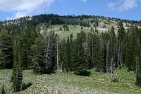 Southwest Ridge
Current wildfires:
Weather forecast from NOAA for Bedford, WY:
Avalanche Conditions:
Maps and Peak Data
USGS Maps: Southern Escarpment
Man Peak, WY 1:24,000
Afton, WY 1:100,000
Elevation: 10,015 feet
Prominence: 435 feet
Isolation: 1.32 miles
Wyoming Rank: 1,078
Lincoln County Rank: 70
County Prominence: 139
Click on the icons to see photos of various peaks surrounding Visser Peak.
View Visser Peak Vista in a larger map
Camping
Campgrounds: Camping Heaven
Several National Forest Campgrounds are available in the area. The Moose Flat Campground located on the Greys River Road is only a short distance from Visser Peak. This would be the best place to stay on the East side. On the West side, the closest campground would be near Afton, Wyoming.
Follow this link for a brochure on the campgrounds in the area.
The trailhead parking area for Strawberry Creek Canyon has plenty of room for camping overnight. There is enough space for several groups to spend the night, but there will be no sanitary facilities.
Backcountry Camping:
Backcountry camping around Visser Peak is among the finest you can find. Campsites with water features are plentiful on both sides of the peak. Forest and meadow are intricately interwoven, providing cover and open vistas alike.
 Putting Green
Remember: This is bear country not only for black bear but also for grizzly bear. Please check out this link to the Bridger-Teton NF Website to view a simple illustration of what a recommended campsite should look like in bear country. It also provides a simple list of recommended campsite practices.
Accommodations:
The nearby towns of Afton and Thayne, Wyoming would be the best places to stay overnight if you wanted a room. Both towns have plenty of services including dining, lodging, gas, supplies and souvenirs.
Flora and Fauna
Some of the more common animals in the Bridger-Teton National Forest are:Deer, elk, moose, bear, bighorn sheep, bison, pronghorn, beaver, pika, swan, crane, eagle and osprey.
 An Evening Visitor
 Salamander
Humans have a tendency to want to get too close to animals. This can be dangerous and even life-threatening to both the human and animal. Please follow this link to read some helpful tips on signs that will indicate that you are too close to an animal.
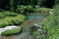
Cutthroat trout are the favorite catch from the Greys River.
Strawberry Lake contains no fish, but has an abundant salamander population.
Wildflowers are abundant and come in many varieties.
| North Fork Strawberry Creek Wildflowers | ||
|---|---|---|
 |  |  |
 |  |  |
 |  |  |
 |  |  |
 |  |  |