Handies Handily
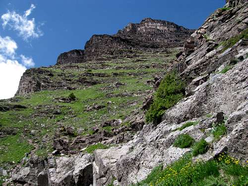
A long and arduous day on Sneffels compelled me to stay another night in the charming little villa of Ouray. I considered my options for the rest of the week. The supposed 2WD road to Yankee Boy Basin had been pretty tough on my poor Camry, and I seriously doubted it could make any inroads towards Handies, even the Grizzly Gulch TH. I posted on 14ers.com to see if I could hitch a ride with anyone else anywhere in the San Juans, near Lake City. Josh (CONative) informed me that they were heading down Friday night and heading up Handies via American Basin. He told me to expect a big, slow group, as it was going to be his and his brother Jason’s 14er finisher. I happily accepted their offer of a ride.
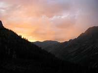
This left me with two days to spare. Thursday the 16th I took the San Juan Skyway to Cortez, taking the obligatory tours of the Pueblo palaces at Mesa Verde. Friday I left Cortez and drove up through Durango, Wolf Creek Pass, and Creede into Lake City. The South Fork area and the drive north to Creede was amazing, with the Rio Grande seemingly flowing right from its namesake Pyramid and lazying its way down to Texas and the Gulf. Lake City was a mess. Bikers had seemingly taken over the town, and Texas plates outnumbered their Colorado counterparts ten to one. I had reserved over the phone the previous night what seemed to be the last hotel room in town, overpaying for a set of decent rooms that lacked Wi-Fi access.
![From N of Creede]() RGP
RGP
I parked at one of campgrounds along the Alpine Loops road, where Josh and his friend Chad picked me up before dawn the next morning. We were well down the rougher portions of the road before I realized that I left my camera in my car. I still had my cell phone camera, but it was a shame, since Handies would provide me with some of the best views I’d be fortunate enough to witness in this lifetime.
We arrived at American Basin slightly after the first tinges of light peeked through the hills behind us. We got our gear ready and waited for the rest of the group, which included Jason, his wife, and several of their friends. Soon everyone was present, for the most part, and we headed up the trail. It was a large group, with several kids attempting their first or second 14er, so we made a moderate pace and soon the group separated. Myself, Chad, and his son Mason took point, and we made a leisurely pace to the summit; I don’t think I broke a sweat all day. At the top the group pulled out a grill, burst open a few beers, lit up the tiki torches, and celebrated Josh and Jason’s achievement. It was a perfect, cloudless day, and I really regretted not having a camera to capture the views.
![TR Pic - Do Not Vote]() Handies Summit-Josh Handies Summit-Josh |
![TR Pic - Do Not Vote]() Handies Summit-Jason Handies Summit-Jason |
![TR Pic - Do Not Vote]() Handies Summit-Me Handies Summit-Me |
North Maroon
With Handies handily down, I had one 14er left on this trip I wanted to cross off: North Maroon. It had not been in my original plans, but on the drive west, somewhere in Western Maryland, I became enamored of the idea of giving it a shot. Not to denigrate Yale, Handies, or even Sneffels, but I felt that my once-a-year trip out west wouldn’t be complete without a memorable (ie harrowing) summit like North Maroon. The prospect was both exhilarating and terrifying. I wasn’t so worried about the class 4 chimney, since there was little exposure involved, but both gullies necessary to gain the chimney and the Northeast Ridge struck me as loose, steep, one slip and you’re toast territory. I posted on 14ers.com to see if anyone else was going to be attempting North Maroon at the same time. If I could find others to come along I would try it, but even though I had soloed Pyramid the prior September, I didn’t feel comfortable by myself on North Maroon.
One week and 3 14ers later I left my motel in Glenwood in the early morning and drove down an empty highway towards Maroon Lake. There would be 4 of us on this trip: myself, Kurt from Illinois, Amy from Colorado, and Jean Roy, a Quebecois, all from 14ers.com. Amy was driving in while Kurt and Jean Roy were already in the area, where they had done South Maroon the day before. In fact, in the last 4 days Jean Roy had taken down Castle, Conundrum, Snowmass, South Maroon, and Pyramid, and he would go on to summit Capitol the following day, in the middle of a 58 14ers in 58 days marathon. Upon hearing this I felt a little more optimistic about our chances for summiting.
I drove down to Maroon Lake the day before, in what has become a now three year old tradition, to scout out the Bells and the weather and to try to ease my apprehensions about the following day’s climb. Knowing they were camped in one of the three forest service campgrounds I was hoping to meet up with Jean Roy and Kurt to hammer out start times and other details. I couldn’t find Jean Roy’s self-described orange Honda Element with Quebec plates, probably the only one in the area, so I figured they were somewhere in town, which they in fact were. I drove back to Glenwood, gorged myself on some greasy pasta from Domino’s, checked the weather, checked and re-checked the route description, and eventually fell into an uneasy sleep.
I’m never a fan of waking up for alpine starts. Even a few years into this hiking thing I still have an inherent nervousness for even the easiest walk-ups; something like North Maroon just magnifies that feeling, and though I would never listen to it, I still hear a little voice that whispers to me, “screw all this effort and danger bullshit, just drive around, grab a few beers, find a pretty lake, and relax.” This primal urge never felt stronger as I found the turnoff for Maroon Lake, but I fought it and ten minutes later arrived at the trailhead. Amy and her friend Ryan were asleep in their car. Jean Roy and Kurt arrived a bit later. We got through the introductions and soon set off in the dark. (Ryan was waiting for some other partners to climb Pyramid. They never showed up, but he soloed it anyway.)
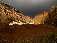
We started later than I had hoped. As we walked by Maroon Lake we could see in the distance small bright sparkles of light shining from the headlamps of other groups. One group was on the Pyramid trail, on their way to the Amphitheatre. Another was making slow but steady progress up the Bell Cord. To benchmark our progress to theirs we were pretty behind, especially after we got mixed up with some of the trails encircling Maroon Lake. It was almost dawn when we got to the trail junction, which we found without too much effort. The grapevine brought me rumours of murky trailfinding between Minnehaha Creek and the Rock Glacier. We were able to follow it in the twilight of the early morning without too much difficulty. There were some muddy sections and narrow sections between vegetation where you almost have to bushwhack, but the first class 3 section wasn’t much of an issue. Dawn brought us through quiet meadows to the rock glacier. Gunsight Notch and the wall of alpenglow glistened rock above and around us gave the feeling of standing a golden stadium, gazing at stands rising thousands of feet above the stadium floor. We wound our way easily through the glacier. Afterwards I figured with increasingly difficult terrain I would drop off my trekking poles. We ascended a slope adorned with evergreens in what I thought was the first gully. I was mistaken; it was only the traverse into the first gully.
![sky on fire]() Sky on Fire Sky on Fire |
![North Maroon Alpenglow]() Northeast Ridge Northeast Ridge |
![NE Ridge]() NE Ridge NE Ridge |
![Gunsight Notch]() Gunsight Notch Gunsight Notch |
![Kurt approaching rock glacier]() Rock Glacier Rock Glacier |
![Rock Glacier Traverse]() Rock Glacier Rock Glacier |
![some trees before 1st gully]() Before 1st Gully Before 1st Gully |
The grassy slope in the first gully was slippery enough to make me miss my poles, and non-technical enough to make regret leaving them behind, but ultimately wasn't a real hindrance. We made our way single file up the gully at an average pace and thus far, I have overestimated the exposure factor. The climber’s trail was pretty easy to follow as we traversed out of the first gully. The almost famous first view of the second gully was a sight to behold, but so focused was I on the climb and the unimaginable dangers above I didn’t give it too much thought. The trail descends a little until you reach the middle of the gully, crossing a rubble/wastefall path before finally climbing back up.
![Close up of 2nd Gully entrance]() Into the Belly Into the Belly |
![Entering the 2nd Gully]() Of the Beast Of the Beast |
![North Maroon]() Looking Back Looking Back |
Cairns guided us a third of the way up the second gully, where they promptly disappeared. Up higher there seemed to be several versions of the same climber’s trail, criss-crossing each other around and about the rocky ramparts. There were more ledges obstructing the way of progress that, though not technical, required us to slow down and scramble one by one through the sections. The gully being only so big the trail was not hard to follow despite the lack of cairns, but as we neared the ridge crest the route got more complicated. We saw what seemed like a cairn that told us to traverse left to start making our way out of the gully. Scree turned into larger, cut blocks, and the grassy terrain was replaced by the rockier, ledgy and perpendicular features that typify the Elk Range. Writing this months afterwards my memory of our route is choppy; it was even in the immediate moment. Jean Roy led the way at this point, tinkering every once in awhile at his GPS while studying the 14ers.com route description. The rest of us just followed, myself focused on the next step and the step after next rather than the big picture of our surroundings and progress through it. (I’m not sure about this tendency. Even when I was solo on Pyramid I have difficulty recalling the specifics of the upper route after the Green Gully, so absorbed was I on only what was immediately in front of me. Maybe that’s a good thing too, if it means paying less attention to any thoughts of exposure). I do recall the trail itself taking almost perpendicular switchbacks, often traversing in the direction of the summit on a horizontal ledge before turning straight up through more vertical sections and steeper scrambling.
![Up the 2nd Gully]() Up Up |
![Down the 2nd Gully]() Down Down |
![At the top of 2nd Gully]() Top of 2nd Gully Top of 2nd Gully |
![looking down 2nd Gully]() Looking Down Looking Down |
![looking down 2nd Gully]() Down Down |
![Along the crest of ridge]() Traverse Traverse |
One of the my favorite moments on a climb is cresting and seeing for the first time what's on the other side of the ridge. I remember my first scramble on Castle and how awestruck I was when Pyramid and the Bells first appeared unexpectedly over the jagged horizon. My memory fogs at when I first glimpsed Capitol, Snowmass, and the lush Pierre Lakes Basin during this climb; according to my pictures it was before we got to the crux chimney. It was an amazing sight to behold, but now, as we were not making ideal time, I was more concerned about the weather than anything else. Our spirits have been dampened by gloom and clouds all day, ever since the sun first found us on the rock glacier, and the lightning storms were supposed to begin between 11 and noon. I was hoping to be on the descent past the first gully by then, and according to that timetable we were behind schedule.
![cloudy morning]()
Jean Roy wasn’t so worried about the weather. Since he’d been climbing 14ers for the past 40 or so days without having to turn back once (and he would not have an unsuccessful summit for the rest of his trip), I was somewhat comforted by his confidence. Back to the route, we found ourselves on some spotty bands of snow once on the ridge proper, bands I expected after having seen them from Maroon Lake the day before. I had brought my ice axe for this very reason. The snow was slushy, slippery, and at a slight angle, but we never had to climb more than 20-30 feet of it at one time.
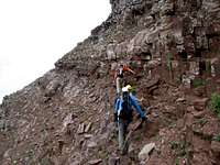
We soon found ourselves below a steep band of rocks with two chimneys ahead of us. The one to the right looked easier and Jean Roy thought it was the correct crux, but I pulled out my route description print-out, soaked in sweat but still readable, and confirmed that the left chimney was the official route. Jean Roy went first, testing the holds through the center of the chimney. He was unsure of how to proceed through the upper half until he found the hidden handhold near the top, and scampering quickly through afterwards. Rather than wait Kurt went to the left of both chimneys and eventually emerged on top. He said the exposure was pretty bad and he wouldn’t recommend it as an alternative. While waiting I saw what looked to be bigger and better holds on the left face of the chimney and climbed the bottom half pretty easily. I ran out of holds halfway through and had to traverse back to the middle, grabbing scant handholds and stepper on scanter footholds. Still, it was preferable to the smooth New Hampshire granite I’m usually hiking on, and I found myself without further ado past the crux.
![inching towards the chimney]() Approaching Chimney Approaching Chimney |
![Class 4 Chimney]() The Chimney The Chimney |
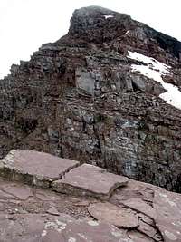
There is supposed to be an easier way around the chimney to the climber’s right. Above the chimney is basically a gentle and even slope of talus that eventually rounds itself around a corner or a rib, and looking in that direction we couldn’t spot any obvious weaknesses, which meant we would likely have to descend the same crux on the way down.
There was still plenty of climbing after the chimney, including several similar semi-technical sections. We walked past the famous precipice of the ridge through a haze; I didn’t look down. The summit was in sight. Right below it was another tricky section which I later found out we could’ve avoided if we had spotted the climbers trail circling it to the left; we descended that trail later. It was all in good fun though, and I’m not one to complain about some extra scrambling opportunities. A few goats awaited us 50 ft from the top, and followed us all the way to the summit. Jean Roy explained they were looking for us to take a piss, so that they could lick the ensuing salt. None of us felt the urge to do so, and the goats soon lost interest.
Of course the view was spectacular. The sun was beginning to break through on the northwest, bathing Capitol and Snowmass in a golden hue while the sky still looked ominous to the west and southwest. A small cloud was in that moment clipping the summit of South Maroon, upon which we witnessed several other climbers. Jean Roy was still confident about the weather, remarking that the shape of the clouds and the wind direction was in our favor. We spent a pretty long time at the top, marveling at the sites and downing some snacks and water.
Eventually, we had to head down, not wanting to take the weather for granted. Moreover, Jean Roy, upon learning that the trail to Capitol Creek was about 2 miles shorter than he originally anticipated, was now itching to strike off his rest day and start heading up in that direction tonight, to summit tomorrow. His feet slipped and glided their way down the ridge with remarkable speed, almost as if the scree and rubble that formed the foundations of our trail simply ceased to exist for him.
I had not that talent, but still we downclimbed faster than I had expected. Jean Roy descended the chimney first; I followed him, face facing out. My hands perched themselves on the surface behind me, my butt sitting on the downsloping edge. I saw an obvious step some distance in front of and below me in the form of an out-jutting slab; I’ve pretty long feet so I was confident I could make the step, but with a clunky backpack behind me and the ice axe hanging off that I was worried that any forward motion would cause the ice axe to push against the rock and propel me more than I would care for, ahead of the chimney and into the open air. Amy offered to grab the axe, but I was in too precarious of a position at this point to take it and hand it to her. Besides, she would then have to deal with it on her downclimb. I finally made the leap of faith and my left foot easily found its intended target. I saw more obvious perches below me and scampered down without much effort, feeling pretty good about myself, that is, until I slipped on the steep snow/slush at the base of the chimney and slid about 10 feet or so. Unhurt, I took a rest and took some pictures of the rest of the group descending the chimney, then gathered up my stuff to continue the downclimb.
![Class 4 Chimney]() Crux Descent Crux Descent |
![descending the chimney]() Crux Descent Crux Descent |
The second gully came up pretty quickly. Jean Roy and Kurt continued to speed down while I descended at a moderate pace. Amy, still recovering from injuries suffered in an avalanche in the Bell Cord a few months prior, followed carefully behind. I tried my best to keep pace in the middle and to keep both Jean Roy and Kurt and Amy within eyesight, as Amy didn’t want to get left behind too far in the group. While they waited Kurt took time to pile some rocks together in the cairn-less upper gully.
We regrouped at the entrance to the first gully.
![down the 2nd gully]() Upper Gully Upper Gully |
![inside the 2nd gully]() Upper Gully Upper Gully |
![2nd gully]() Upper Gully Upper Gully |
![typical terrain, upper 2nd gully]() Upper Gully Upper Gully |
![bottom of 2nd gully]() Upper Gully Upper Gully |
![2nd gully overview]() Upper Gully Upper Gully |
![Pyramid Peak]() Pyramid Pyramid |
|
![gully traverse]() Upper Gully Upper Gully |
![connector trail]() Gully Traverse Gully Traverse |
![returning to 1st gully]() Gully Traverse Gully Traverse |
![Pyramid Peak]() Pyramid Pyramid |
![Descending 1st Gully]() Lower Gully Lower Gully |
![1st gully overview]() Lower Gully Lower Gully |
![Trail and trailhead]() Lower Gully Lower Gully |
![down the 1st gully]() Lower Gully Lower Gully |
![Trail entering 1st gully]() 1st Gully Entrance 1st Gully Entrance |
![Along the trail]() Tranquil Meadow Tranquil Meadow |
Jean Roy was right about the weather; the sun had come out by the time we downclimbed the crux, and it stayed out for the remainder of a brilliant day. Perhaps this, as well the fact that our difficulties were mostly behind us, gave us a false sense of security. Certainly having come up the same way we got complacent with our routefinding. It was not before long we lost the trail among the brush and talus fields; most likely we overshot it and missed it when the trail swung right and down towards Minnehaha Creek. We aimed for a spot on the creek where we could cross, between the N Maroon trail offshoot and Buckskin Pass. To reach it required some tedious scree hopping and some brutal bushwacking through steep, downsloping brushes almost twice as tall as myself (and I’m 6’3”) and packed thicker than Charlie Weis or Rex Ryan’s arteries.
Back on the trail, and it was all downhill from there. Amy was hurting though; she had fallen a few times after we lost the trail and jammed her toe. I told her not to worry, the toenail was going to fall off anyway, might as well consider it a badge of pride. As a result we took our time back down the crowded trail to the parking lot. A safe and successful summit certain, I felt the proverbial weight lifted off my shoulders. I had been strangely homesick this entire trip; now I was homesick no more. Maybe a lot of the homesickness was just anxiety about a mountain that deserves to be taken seriously.
In years past, after an arduous climb my legs are jelly. Being in much better shape this summer I was nevertheless surprised that I still felt great physically upon returning to the trailhead. Mentally, not so much . I considered stretching my trip another day to get a few cheap summits out of the way via the Decalibron, but the lure of spending the weekend at home was just too hard to resist. The final nudge came as I was discussing the dilemma with a friend; he said, why not finish on top? I was convinced.
(He was biased though. I was scheduled to apartment sit for him and his rabbits in the city while he and his girlfriend went to Spain for a week, and he wanted me back in Boston as early as possible.)
I settled down in Denver for the night. After a week in the mountains it was refreshing to be in a city again. I was exhausted and about to pack it in when a tornado tore the roof off my Ramada, knocked out the electricity, and poured a nearby lake into the hotel. My room and my belongings, thankfully, were spared. Other guests were not so fortunate.
![For TR - Do Not Vote]() After Tornado After Tornado |
![For TR - Do Not Vote]() After Tornado After Tornado |
The remainder of the drive home was uneventful, other than the usual daily quota of torrential rains. I had the opportunity to play the tourist a few more times during the trip, taking the gondola up to the top of the Gateway Arch in St. Louis and a few walks in the rain at Cuyahoga Valley National Park, outside of Cleveland. An audiobook of horror stories and another thunderstorm guided me through the final stretch of night driving. Another vacation come and gone. Another year of yearning to be out west. But until I move, home is still in Massachusetts, and I was glad to be home at last.
I know I've gone picture crazy in this TR, but I can't resist. A few more parting shots.
![Pyramid Peak]() Pyramid Pyramid |
![Northeast Ridge - North Maroon]() NE Ridge NE Ridge |
![Pretty flowers]() Pretty Flowers Pretty Flowers |
![Maroon Bells]() Pretty Peaks Pretty Peaks |


Comments
Post a Comment