
-
 6440 Hits
-
 71.06% Score
-
 1 Votes
|
|
Route |
|---|---|
|
|
34.78790°N / 88.2418°W |
|
|
Trail Hike |
|
|
Less than two hours |
|
|
Class 1 |
|
|
Approach
From the intersection of US-72 & SR-25 south of Iuka:
North Side
- Continue West on US-72 for 1.3 mi and crossover to the South (L) onto Mt. Gilead Rd.
- Follow this paved road as it curves back West for 0.6 mi to CR-233. This is the lower trailhead for the route
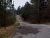
- Turn South (L) on CR-233 and continue 0.5 mi to a trailhead with a metal gate obstructing car access. This is the upper trailhead for the route.
 |  |  |
Route Description
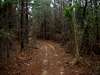
If you choose to hike from the lower trailhead, hike South on CR-233 for 0.5 mi, passing the Kirk Cemetary on climber's left at 0.05 mi. As mentioned elsewhere on the page, beware the dogs at the top of the first noticeable hill that you hike up. They will likely run up from a house on the right, and bark until you get a few hundred yards past their territory. Upon reaching the upper trailhead, bear southeast (L) onto the trail proper.
Hike generally south-southeast up the ridge trail for another 0.5 mi until you meet up with the South Side road route. Climb up the remaining 0.4 mi up this road to a level summit area with a turn-around and a picnic table. The USGS benchmark is in the center of the turn-around.
 |  |
Essential Gear
Only basic hiking gear is required. There is no water available on Woodall Mountain, so take all that you will require.
Miscellaneous Info
If you have information about this route that doesn't pertain to any of the other sections, please add it here.