
|
|
Mountain/Rock |
|---|---|
|
|
40.84650°N / 107.0496°W |
|
|
Routt |
|
|
Hiking, Mountaineering, Scrambling, Skiing |
|
|
Summer, Fall |
|
|
9761 ft / 2975 m |
|
|
Overview
The Slater Peaks are a local name for a group of peaks in the in the northeast section of the Elkhead Mountains. Peak 9761 is north of the highest Slater Peak, so on this page will be referred to as “North Slater Peak”. The mountain is mostly forested and not as conspicuous as some of its neighbors such as Nipple Peak, Sand Mountain and Hahns Peak. It lies about halfway between Diamond Peak on the south and Nipple Peak on the north. From any road, it is only highly visible from the immediate vicinity around Hahns Peak Lake. North Slater is easier to climb, but because it is below 10,000 feet it isn’t climbed as much as Slater Peak.When we climbed North Slater Peak on June 16 2012, we found five signatures in the summit register in the last fourteen years (one in 1998, one in 2000, two in 2002 and one in 2011), making this a slightly above average peak in popularity for less than 10,000+ foot peaks in the Elkhead Mountains.
Several aspects of the Elkhead Mountains make this a rather unique mountain range in Colorado. It is certainly possible that the Elkhead Mountains are the least known of the major mountain ranges in Colorado. This is partially because the range is a long way from any metropolitan area, and partially because the Elkhead Mountains are fairly low by Colorado standards, as there are no peaks reaching 11,000 feet. There are also few lakes, so the range isn’t visited by fishermen. Despite their low altitude, the Elkhead Mountains receive much snow, and snow lasts into July or later on the higher peaks. Most of the peaks in the Elkhead Mountains see very few ascents, but Hahns Peak, the eastern-most peak in the range is a popular climb for residents of Steamboat Springs. The Bears Ears see quite a few ascents by Elkhead standards, because of their prominent shape and visibility from the Yampa River Valley. Black Mountain is also climbed fairly often because it is the highest point in Moffat County, and the popularity is on the increase with more county highpointing interest. Sand Mountain must be a fairly popular (by Elkhead standards) climb as well, as there is a trail to the top, and as it is the first and only mountain in the range where I have ever met anyone. This was on Labor Day weekend, 2005, when we saw 3 other hikers. Most of the rest of the peaks see few ascents, and one ranger has told me some of the peaks only have a few names in the registers since 1980. So, there are few hikers around, but hunting is another story. The Elkhead Mountains are very popular for hunting in the fall and contain large populations of deer, elk, bear, etc.
One thing unique about the range is that hiker use is overall actually decreasing, rather than increasing as it is in most places in Colorado. The summit registers (which the Forest Service keeps record of) on most peaks indicate that they have had more ascents in the 1960’s and 1970’s than they do now. Even before that, there were many summit logs from the 1930’s and 1940’s from sheepherders.
The Elkhead Mountains are made of old volcanic rocks 17-25 million years old. One thing unusual is that the Elkhead Mountains run west to east as opposed to north and south as most of the ranges run in North America. It is impossible to describe the general forms of the peaks because they are all so different, but most of the peaks are isolated rises from a huge plateau which forms the bulk of the Elkhead Mountains.
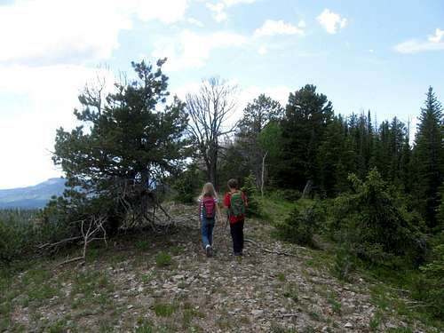 Nearing the summit of North Slater.
Navagational Warning
Warning:The topo maps available don’t show the roads or trails around this mountain accurately. The closest one that bears resemblance to reality is the Forest Service Map-Routt National Forest, but it is of a small scale. The USGS maps don’t show many of the roads in the areas, but seem to show roads and trails that don’t exist; at least not any more.
Update:
The USGS has (finally) updated the 7.5 minute maps. They were scheduled to be produced for Colorado last year, but I’m not sure when they will hit all the stores. Right now you can get/see/print/buy the new 7.5 minute maps on My Topo.
The good news is that all the roads and trails are FINALLY accurate for the Elkhead Mountains (and undoubtedly other areas as well). After receiving the new maps, I am very pleased to see that the roads and trails are in the right places. I am also very pleased that the USGS has a new agreement with the US Forest Service and within the national forest service areas, the private land holdings are shaded (but only in USFS areas, land ownership is not shown outside FS lands) on the 7.5 minute scale maps.
Getting There
From Steamboat Springs, drive to the north end of town and to where County Road 129 leaves Highway 40. A sign marks "Clark" and "Hahns Peak". This is the same road heading to the airport. Drive north on CR 129 for approximately 30.8 miles.Turn left (east) on FR 129 (gravel), marked for Hahns Peak Lake, to another junction after 2.1 miles. Turn right and follow the road for 2.3 miles, around a bend to the trail marked as “Prospector Trail”. A small parking area is just beyond the trail sign.
The road can be slightly rough near the end, but is usually good for all vehicles during the summer season.
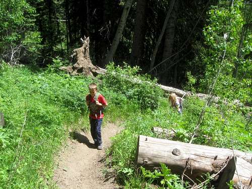 This is part of the approach trail to North Slater Peak not far from teh trailhead.
Routes Overview
Via Willow CreekThis route follows the Prospector Trail up to the saddle between Slater Peak and North Slater. From there it climbs up a south ridge to an east-west ridge which is climbed west to the summit.
The round trip distance is only about 3.0 miles with 1000 feet elevation gain, but with a steep off trail scramble for the 2nd part of the route. See the route page for details.
 Nearing the top of the South Ridge of North Slater.
Other Routes
The saddle can also be reached from the west and various 4wd roads, but it would take a much longer time to get there.
The east ridge and north slopes appear to be reasonable routes as well.
Red Tape
There is no red tape here, so make sure to tread lightly.Camping
There are many informal campsites along the road to the trailhead.Hahns Peak Lake is a Forest Service Campground and is very close to the trailhead. Also in the same general area to the east are the campgrounds at Pearl Lake and Steamboat Lake State Park. These are crowded on summer weekends, and reservations are recommended. All the campgrounds are fee-use areas.
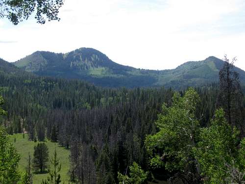 Slater Peak (left) and North Slater (right) as seen from Hahns Peak Peak Lake.
When to Climb
Late June or early July through early September could be considered the normal season to climb the mountain. The access roads do not open until late June or early July in most years. These roads could certainly be walked, snowshoed, or skied before then (though it would be a very long one day or easier two day trip).A snowmobile would make this a one day climb in the winter. The Elkhead Mountains are a very popular hunting destination in late August, September and October (until snow closes the road), so use extreme caution at this time of year.
 Giant aspen tree seen on the approach as seen in mid-June.
Mountain Conditions
CLICK HERE FOR THE SLATER PEAKS AREA WEATHER FORECASTBelow is the National Weather Service Climate Summary of Steamboat Springs. The data is from 1908-2005. This is the closest long term weather station, but be aware that higher elevations will be much wetter and colder. Steamboat Springs is at 6695 feet elevation, so expect the temperatures on North Peak to be 10-15 degrees colder than in Steamboat (except for cold winter nights).
| MONTH | AVE HIGH | AVE LOW | REC HIGH | REC LOW | AVE PREC (in) |
| JAN | 29 | 1 | 57 | -54 | 2.47 |
| FEB | 34 | 4 | 59 | -48 | 2.24 |
| MAR | 42 | 13 | 70 | -34 | 2.11 |
| APR | 54 | 24 | 79 | -15 | 2.28 |
| MAY | 65 | 31 | 88 | 8 | 2.08 |
| JUN | 75 | 36 | 96 | 19 | 1.49 |
| JUL | 82 | 41 | 97 | 25 | 1.54 |
| AUG | 80 | 40 | 98 | 20 | 1.60 |
| SEP | 72 | 33 | 93 | 6 | 1.81 |
| OCT | 60 | 24 | 89 | -16 | 1.89 |
| NOV | 43 | 14 | 72 | -28 | 1.97 |
| DEC | 31 | 3 | 64 | -44 | 2.38 |