
|
|
Mountain/Rock |
|---|---|
|
|
40.72004°N / 107.31102°W |
|
|
Routt |
|
|
Hiking, Scrambling |
|
|
Summer, Fall |
|
|
8971 ft / 2734 m |
|
|
Overview
Make no mistake about it; Slide Mountain is a pain in the butt to climb. Furthermore, there are no real views from the summit.I debated whether or not to include a mountain such as this on Summitpost, but maybe I can justify it by saying that I climbed this mountain so you would not have to and besides, someday I hoped to add all the climbable (without trespassing) mountains in the Elkhead Mountains to Summitpost.
My kids and I climbed Slide Mountain because we needed a short mountain to climb on a Saturday since I had other commitments (chores) to do at home. It was soon apparent that the joke was on us and what appeared to be a short and easy climb on the map turned out to be a not-so-fun thrash fest.
The mountain does have a few redeeming qualities. Our descent route, the east ridge really isn’t that bad of a route and although there are no summit views, some of the higher slopes do offer some unique and nice views of the Bears Ears. The slides are interesting. Solitude is almost 100% guaranteed on this mountain!
Slide Mountain indeed is sliding. The mountain is made of volcanic mud and rocks and there are many big cracks in the earth where the slopes of the mountain are literally oozing downhill. Many trees are toppled and dead by the slow moving landslides. It’s actually rather eerie and the slopes of the mountain act like some kind of glacier (complete with moraines and crevasses), only made of mud.
The elevation of the mountain is not on the 7.5 minute topo map, but is on the Routt National Forest map.
Several aspects of the Elkhead Mountains make this a rather unique mountain range in Colorado. It is certainly possible that the Elkhead Mountains are the least known of the major mountain ranges in Colorado. This is partially because the range is a long way from any metropolitan area, and partially because the Elkhead Mountains are fairly low by Colorado standards, as there are no peaks reaching 11,000 feet. There are also few lakes, so the range isn’t visited by fishermen. Despite their low altitude, the Elkhead Mountains receive much snow, and snow lasts into July or later on the higher peaks. Most of the peaks in the Elkhead Mountains see very few ascents, but Hahns Peak, the eastern-most peak in the range is a popular climb for residents of Steamboat Springs. The Bears Ears see quite a few ascents by Elkhead standards, because of their prominent shape and visibility from the Yampa River Valley. Black Mountain is also climbed fairly often because it is the highest point in Moffat County, and the popularity is on the increase with more county highpointing interest. Sand Mountain must be a fairly popular (by Elkhead standards) climb as well, as there is a trail to the top, and as it is the first and only mountain in the range where I have ever met anyone. This was on Labor Day weekend, 2005, when we saw 3 other hikers. Most of the rest of the peaks see few ascents, and one ranger has told me some of the peaks only have a few names in the registers since 1980. So, there are few hikers around, but hunting is another story. The Elkhead Mountains are very popular for hunting in the fall and contain large populations of deer, elk, bear, etc.
One thing unique about the range is that hiker use is overall actually decreasing, rather than increasing as it is in most places in Colorado. The summit registers (which the Forest Service keeps record of) on most peaks indicate that they have had more ascents in the 1960’s and 1970’s than they do now. Even before that, there were many summit logs from the 1930’s and 1940’s from sheepherders.
The Elkhead Mountains are made of old volcanic rocks 17-25 million years old. One thing unusual is that the Elkhead Mountains run west to east as opposed to north and south as most of the ranges run in North America. It is impossible to describe the general forms of the peaks because they are all so different, but most of the peaks are isolated rises from a huge plateau which forms the bulk of the Elkhead Mountains.
 These slopes of Slide Mountain aren't steep, but they are sliding down the mountain like a glacier, (complete with moraines and crevasses-not seen in this photo), only made of mud. The dead trees are sliding down the mountain as well.
Navigational Warning
Warning:None of the maps available show the roads (and there are no trails) on to Slide Mountain accurately, and route is no exception. The closest one that bears resemblance to reality is the Forest Service Map-Routt National Forest, but even that one doesn't show all the roads, while showing others that have long faded away or that don't exist.
The USGS maps do not show the last road to the trailhead at all. The USGS maps don’t show some of the other roads in the area as well, but seem to show roads and trails that don’t exist; at least not any more.
Update:
The USGS has (finally) updated the 7.5 minute maps. They were scheduled to be produced for Colorado last year, but I’m not sure when they will hit all the stores. Right now you can get/see/print/buy the new 7.5 minute maps on My Topo.
The good news is that all the roads and trails are FINALLY accurate for the Elkhead Mountains (and undoubtedly other areas as well). After receiving the new maps, I am very pleased to see that the roads and trails are in the right places. I am also very pleased that the USGS has a new agreement with the US Forest Service and within the national forest service areas, the private land holdings are shaded (but only in USFS areas, land ownership is not shown outside FS lands) on the 7.5 minute scale maps.
Getting There
Directions to the trailhead will be brief because you had better have a Routt National Forest map in hand. Don’t try finding the trail without it.My route from Craig, followed Highway 40 east to County Road 29 (CR29), turned north past Elkhead Reservoir, right on CR 18, left on CR 76 to a major junction (there are several minor junctions before this, and at one unmarked one, I took a short detour left at a ranch).
A sign will say the main road right is private. Turn left on the 4wd road and drive it to the trailhead. The road is rutted and rough in places, and stay off it when it is wet. It should open in mid-June in most years, but sometimes later. 4wd is definitely required for the last few miles, but you can walk it if you have a car. The trailhead is at an old stock pond dam and a trail sign.
If coming from Hayden, you can head directly north on CR 76 and stay on it all the way to the junction with the private road mentioned above. This will be the least complicated route for most people.
 This is the biggest Scrub Oak that I have seen and is seen not far from the trailhead.
Routes Overview
This is one of my few mountain pages which I won’t provide a route page attachment. You are basically on your own for this one.We climbed up the southeast face. I call this the “Pain in the Butt" or "Bring Your Worst Enemy Route”. On our descent we found a much better route (the East Ridge).
The East Ridge really isn’t too bad. From the trailhead, head NNE (or even almost due north if you want to follow the trail for some of the distance) to the east ridge of the mountain. From the summit, this ridge first heads east and then curves to the northeast. Once on the ridge, follow it to the summit. Luckily there are some elk trails along the way. There is some minor bushwhacking, but it’s nothing like the SE face.
 Bushwhacking up the southeast face of Slide Mountain. For bonus points, try and find the two kids.
Red Tape
There is no red tape here. Tread lightly.Camping
There are good campsites right at the trailhead and a few on the road before the trailhead as well. Elkhead Reservoir has the nearest official campground.When to Climb
July through early September could be considered the normal season to climb the mountain. The access road usually doesn’t dry out until July, and it would be a really long walk in the winter.The Elkheads are a very popular hunting destination in September and October (until snow closes the road), so use extreme caution at this time of year.
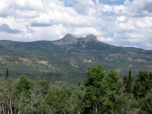 Bears Ears as seen from near the summit of Slide Mountain as seen in September.
Mountain Conditions
CLICK HERE FOR THE SLIDE MOUNTAIN AREA WEATHER FORECASTBelow is the National Weather Service Climate Summary of Steamboat Springs. The data is from 1908-2005. This is one of the closest long term weather stations, but be aware that higher elevations will be wetter and colder. Steamboat Springs is at 6695 feet elevation, so expect the temperatures on Slide Mountain to be 5-8 degrees colder than in Steamboat (except for cold winter nights).
| MONTH | AVE HIGH | AVE LOW | REC HIGH | REC LOW | AVE PREC (in) |
| JAN | 29 | 1 | 57 | -54 | 2.47 |
| FEB | 34 | 4 | 59 | -48 | 2.24 |
| MAR | 42 | 13 | 70 | -34 | 2.11 |
| APR | 54 | 24 | 79 | -15 | 2.28 |
| MAY | 65 | 31 | 88 | 8 | 2.08 |
| JUN | 75 | 36 | 96 | 19 | 1.49 |
| JUL | 82 | 41 | 97 | 25 | 1.54 |
| AUG | 80 | 40 | 98 | 20 | 1.60 |
| SEP | 72 | 33 | 93 | 6 | 1.81 |
| OCT | 60 | 24 | 89 | -16 | 1.89 |
| NOV | 43 | 14 | 72 | -28 | 1.97 |
| DEC | 31 | 3 | 64 | -44 | 2.38 |