|
|
Route |
|---|---|
|
|
40.52670°N / 111.7553°W |
|
|
Mountaineering |
|
|
Spring, Winter |
|
|
A long day |
|
|
50 degree snow |
|
|
Overview
There are a number of fantastic routes up Lone Peak and the Northeast Couloir is one of the best. A steep sustained angle, exposed terrain, stunning views, and a beautiful alpine environment make this one of the classics! This route is typically pursued as a ski descent in the winter (powder snow), a snow climb in the spring (firm snow), and an alpine rock climb in the summer (mixed climbing).Click for the Full Trip Report on my photography website.
ATTENTION: It is important to note that the Northeast Face of Lone Peak is steep, dangerous, and avalanche prone. Only attempt this route under safe conditions and with proper knowledge and experience in avalanche terrain.
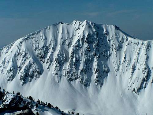
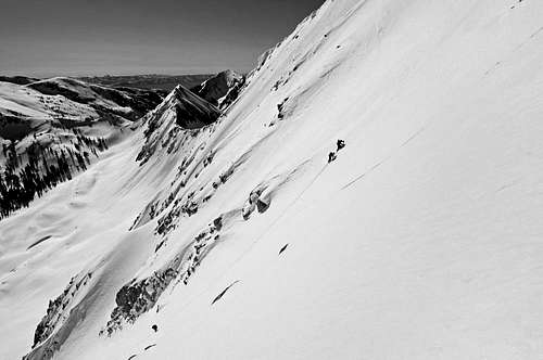
The Northeast Face of Lone Peak
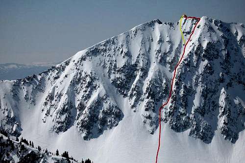
Northeast Couloir (red), Left Fork to Summit (yellow).
Getting There
We ascended this route from Bells Canyon and descended through Big Willow Canyon.Here are the trailhead locations as described on the Lone Peak home page:
Bells Canyon Trailhead
This trailhead sits at 5,130 feet. It is located at 10200 S Wasatch Boulevard near the town of Sandy. This trailhead provides an approach to the eastern region of Lone Peak.
Hidden Valley Park Trailhead
This trailhead sits at 5,100 feet. It is located at 11500 S Wasatch Boulevard near the town of Draper. This trailhead provides access to the newly named Sawmill trail and approach via Big Willow drainage.
Approach to Northeast Face
Approach up Bells Canyon:When this route is approached in winter or spring, the majority of the Bells Canyon trail will likely be snow covered. The first 2-3 miles of the trail tends to see a lot of hiking traffic, but beyond that you'll be breaking trail. With the snow cover, there are no obvious landmarks to guide you on the hike up Bells Canyon. Essentially, we followed the creek east for the first few miles, then when Bells Canyon begins to curve south, we hiked high on the right (west) side of the canyon. The terrain is straightforward, but the hiking is a bit steep and strenuous in the middle section of Bells Canyon. If you have not hiked up Bells Canyon before, it would be a good idea to recon this hike before approaching the Northeast Face Direct route in the early morning darkness.
We started at 3:00am and reached the base of the Northeast Face at 8:00am.
Approach Stats:
5.6 miles one-way
4,670 vertical feet
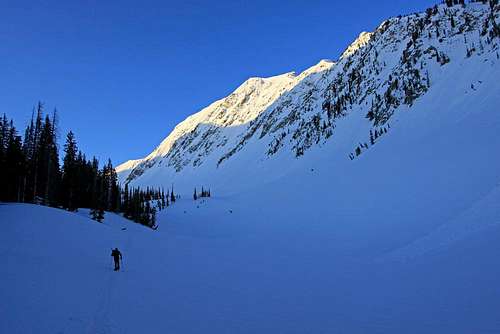
Approaching the Northeast Face.
Northeast Face Direct route
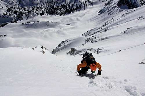
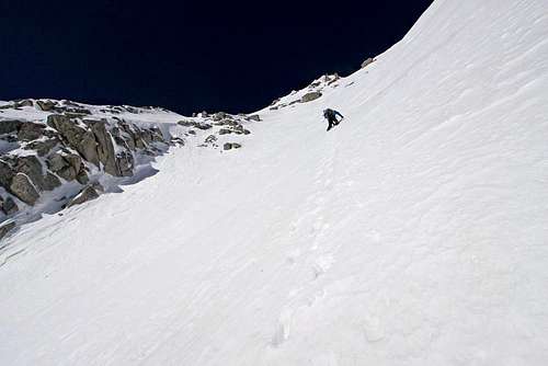
1. The lower third gradually steepens to 50 degrees. Depending on snow cover, the bottom of the couloir might provide some mixed climbing through broken granite slabs. In May 2011, the snow was very steep and covered this lower cliff band.
2. The middle couloir eases back to 40-45 degrees.
3. The upper third steepens to 50 degrees and provides an exciting climb with exposure and ambience. The middle line of the upper third has overhanging cornices on the ridge, so you'll likely branch left or right to exit the route on the summit ridge. The left exit places you at the summit block. The right exit places you just before the famous "boulder" on the summit ridge.
We started the Northeast Face Direct climb at 8:00am and we were on the summit at 9:30am.
Northeast Face Direct Stats:
0.4 mile one-way
1,453 vertical feet
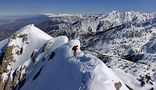
Descent
Whether you take the left of right branch of the upper couloir, you'll have to descend the exposed summit ridge to the north shoulder of Lone Peak. From the north shoulder, we chose to descend Big Willow Canyon. There are two steep, long glissades and a lot of forest hiking down low. In the forest, there are red tags on the pinetree trunks to help you stay on trail. The trail travels on the left (south) side of Big Willow Canyon and eventually traverses over into Little Willow Canyon as you near to the valley. If you haven't traveled this canyon before, a prior recon will help you with your descent.We started our descent at 10:30am and we were at the Big Willow trailhead at 2:00pm.
Descent Stats:
4.5 miles one-way
6,153 vertical feet
Essential Gear
Crampons, ice axe, helmet, possibly avalanche gear. Snowshoes or skis are necessary to avoid postholing on the approach and descent.Some rock climbing protection might be helpful for a mixed climb (summer time).
In the winter and spring, this route will not take an protection. Maybe pickets if the snow is hard in the late spring / early summer.