
-
 26262 Hits
-
 79.04% Score
-
 10 Votes
|
|
Route |
|---|---|
|
|
42.77920°N / 109.2247°W |
|
|
Backcountry technical rock |
|
|
Most of a day |
|
|
IV 5.8 |
|
|
Approach
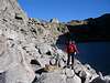
From the usual climbers' camps located near the stream downcanyon from the South Buttress of Pingora, the easiest approach to the Northeast Face is to follow developed trail down to Lonesome Lake, then up the drainage to the north of Pingora, following a good and well-cairned climbers' trail. This approach is significantly easier and quicker than talus-hopping along the base of the East Face.
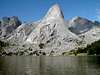
In the attached photo from Lonesome Lake, the easy grassy approach can be seen leading up to the right-hand edge of the face. The route lies very near the right skyline. The entire route is best viewed from the hillside north of Lonesome Lake: well worth the walk on a rest day if you're planning on climbing this line.
 |  |  |  |  |
Route Description
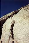
See topo
Note that in the most recent guidebook topos, there is a problem with lengths of pitches and with the "rightward traverse on ledges" in the vicinity of pitch 5. Many parties traverse too low on the route, and too far right, resulting in encounters with long sections of steep, difficult ground, as evidenced with many bail slings on that section of the face.
 |  |  |  |  |
Essential Gear
Nuts, cams from small to 3", a few larger pieces to 4" are also useful. We used a set of 50m twin ropes to facilitate descent in the event of a storm or descent off the South Buttress, which we had climbed a few days previous.
Descent via the South Face route can be made with a single 60m rope, with some exposed but doable downclimbing in a few places to reach the anchors for the next rap.
 |  |
Miscellaneous Info
If you have information about this route that doesn't pertain to any of the other sections, please add it here.
murf - Aug 23, 2005 1:45 pm - Hasn't voted
Route CommentAmusing to see almost identical corrections to the ones my partner and I annotated in the guide - great topo.
rpc - Sep 6, 2005 5:11 pm - Voted 10/10
Route CommentIf you're in a jam or just want to go with a single line...
We rapped the descent route with a single 60 meter rope 2 days ago. Very close but doable:
First rap is just right length for a 60 meter rope (brings you as described on topo to the large ledge).
Scramble down 10-15 feet (exposed) and left (climbers' left) to the next station.
Rap right (climbers' right = toss ropes left) - your feet will touch the next rap boulder/set up as you run out of rope - be CAREFUL and know what you're doing (if you've taken a foot off of your 60 meter rope, you won't make this rap).
One more single 60 meter rap brings you to the huge ledge.
In retrospect, we should've not been lazy and done double rope raps...
standinginawe - Sep 8, 2005 10:05 pm - Hasn't voted
Route CommentAs for the rap, we did it last week twice, with a 60m rope. Although there are reportedly many rap stations varying in length between them, we found that the standard rap route coming down from the 3-pitch South Butress route was easily made with one 60m rope. HOWEVER, as said already, please exercise caution or knot the rope at the ends so as to not come off at the stances - they are all VERY close. Anyway, the raps are obvious, but as already stated, at the second rap station, THROW LEFT and rap down climbers right to the final stance above the start of the South Butress route.