
-
 3390 Hits
-
 76.66% Score
-
 7 Votes
|
|
Route |
|---|---|
|
|
36.81222°N / 117.03944°W |
|
|
Hiking, Scrambling |
|
|
Spring, Fall, Winter |
|
|
Class 2+ |
|
|
Overview
Maybe it's the fact that the northeast ridge looks rugged and exposed, but what according to some guidebooks is the suggested route on Thimble Peak (this is the route covered on the other SP route page for Thimble) is neither the shortest nor the easiest (in terms of how strenuous and how much elevation gain), and the northeast ridge, despite its appearance, is more direct and should never become more difficult than Class 2+.Thimble Peak is a small summit with outstanding views including the sand dunes of Mesquite Flat, Corkscrew Peak, and Telescope Peak, the monarch of Death Valley National Park. The route via the northeast ridge is less than two miles, of moderate difficulty, and well worth the effort. As long as you don't mind a little scrambling and a little exposure, this is the way to go and there is no real reason to use the longer route unless you want to pair the two for a longer tour of the peak.
I must agree with the author of the Thimble Peak page that it is surprising that Thimble is not on the Sierra Club DPS list, as it is an exceptional peak.
Getting There
The drive in might be the toughest part, though it shouldn't be tough most of the time. The approach starts from many miles along a one-way unpaved road, though, so it might be wise to check on current conditions before heading out.From the Daylight Pass Road, which connects the Stovepipe Wells area of DVNP with Beatty, Nevada, turn onto the signed Titus Canyon Road about three miles northeast of the CA/NV border and drive 12 miles to Red Pass (not signed but pretty obvious). This road is recommended for high-clearance 4wd vehicles, but many passenger vehicles can make the trip if driven with care, though there may be some unavoidable scrapes of the undercarriage.
There is not much parking available at Red Pass itself (see the second photo below), so try not to hog the space (note in the photo below that I did not really follow my own advice-- oops). If the tiny pullout there is full, park without blocking the road or head downhill until you find another good pullout.
 Red Pass Red Pass |
 Red Pass from above Red Pass from above |
From Red Pass, it's 14 miles down and through Titus Canyon to Scotty's Castle Road.
Route Description
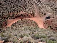
According to my GPS track, the route is 1.7 miles to the summit with about 1100' of elevation gain from car to summit, but there is an unavoidable drop along the way of about 300', and it must be reclimbed on the return. Therefore, total elevation gain on the route is more like 1700' round-trip.From Red Pass, hike up the ridges. There is a beaten path most of the way, but sometimes it disappears or is very faint. However, the way is obvious if you know how to read a map. This page features two very nice submissions by SP member MoapaPk: a route diagram drawn on a map and a photograph of the ridge route itself.
 Route diagram by MoapaPk Route diagram by MoapaPk |
 Route map by MoapaPk Route map by MoapaPk |
 My GPS track My GPS track |
Once you reach Thimble Peak itself and its northeast ridge, the best way becomes pretty intuitive because it is about the only way without straying from the ridge. At times, you may wish to use your hands as you head up the dark, sharp volcanic rock, but it was never harder than Class 2+ for me and shouldn't ever be harder than Class 3. If it is, you are doing something really wrong.
 |
 |
 |
 |
Do take some time to get close to the sheer cliffs and enjoy the precipitous views.
 Summit Summit |
 Cliffs Cliffs |