
|
|
Route |
|---|---|
|
|
39.00970°N / 106.8608°W |
|
|
Snow climb/Scramble |
|
|
Half a day |
|
|
Class 2 + |
|
|
Approach
From the Castle Creek road, hike or drive from the TH which starts at 9,800' on the Pearl Pass Road. Continue up the road over a creek crossing at 10,200'. Hikers can cross over a well constructed foot bridge and if you drive you must cross in the creek. The next creek crossing comes at 11,000', but another well constructed bridge has been built. This time both hikers and vehicles can use the bridge. Shortly after the second creek crossing, you will see the junction for Pearl Pass Rd. and the Montezuma Basin Rd.. Take the fork to the right, which will take you into the Montezuma Basin. From this point the road will get much rougher and can only be traveled by foot or by 4WD high clearence vehicle. Continue up the road to the 12,800' parking lot. If you start from the TH, figure 10 miles round trip. From the 12,800' parking lot, figure around 4 miles.
 |  |
Route Description
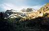
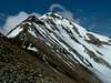
From the 12,800' parking lot, work your way up the permanent snow fields to the southwest. If you are not comfortable on the snow, it is possible to climb the steep scree slopes. However, this will more than likely make for slower travel. As you make your way up the snow fields, the terrain will start to level off and Castle and Conundrum will come into view. From here, you will notice the trail to the left leading to the northeast ridge. Gain the trail and follow it up to the saddle on the northeast ridge. From the saddle it starts to get a little tricky. There is a faint trail, however you have to decide whether to go over or around the rock towers along the ridge. Going over will keep you clear of most of the loose scree, however you must deal with more exposure. If you choose to go around the rock towers, you will stay on the north/northwest side of the ridge, which is not nearly as steep. As you continue towards the summit, you will arrive at the crux of the route just 20' below the summit. If you are thin and agile, you will be able to work your way up between two rocks, which keep you free of exposure, and onto the trail that leads to the summit. If not, you must follow the trail, which traverses the southside of the ridge and has considerable exposure. Also, the ledge around the southside is only about a foot wide, so take considerable care. You are only on this ledge for five feet or so, but it is still enough to get your attention. After clearing the ledge, it is an easy two minute hike to the summit.
 |  |
Essential Gear
Standard Colorado hiking gear should be used. In addition, if you are familiar with the use of an ice axe and crampons, you will find these particularly useful. Crampons will make the ascent of the snowfields a lot faster. In addition, an ice axe will be appreciated when glissading down the permanent snow fields. There is exposure on this route, so short roping or some belay is recommended for the inexperienced.
Miscellaneous Info
If you have information about this route that doesn't pertain to any of the other sections, please add it here.