
-
 19037 Hits
-
 79.76% Score
-
 11 Votes
|
|
Route |
|---|---|
|
|
37.69920°N / 107.8064°W |
|
|
Hiking, Mountaineering, Scrambling |
|
|
Spring, Summer, Fall, Winter |
|
|
Half a day |
|
|
Class 3 |
|
|
Background
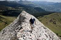
 SP Member Tonka working the higher reaches of the sustained crux section.
This is a dynamite route that falls squarely into the "short but sweet" category. A relatively short distance and moderate elevation gain coupled with an airy ridge scramble make for a lot of bang for the buck. A sustained crux section where a fall could have pretty negative consequences is where plenty of hikers turn around and the scramblers continue. With good weather on their side, fit climbers during the summer could start this route after daybreak and be back down in Silverton, showered and for lunch by Noon or a bit after.
Distance: 4.5 miles roundtrip
Elevation Gain: 2,400 feet
Getting There & Approach
 Wildflower jungle near the Coal Bank Pass Trailhead.
 Engineer Mountain Columbine
The Northeast Ridge can be accessed from two different places, Coal Bank Pass and Coal Creek, which is a mile or so north of Coal Bank Pass on HWY 550. Both approaches involve less than two miles of hiking one way. The Coal Creek approach is a bit longer, but is not as steep as the Coal Bank Pass approach.
 Northeast Ridge in winter (ajfraser)
 Heading into the notch | Liba Kopeckova
Coal Bank Pass is 35 miles north of Durango, 13.5 miles south of Silverton, on Route 550. There is a parking area and restroom facility on the east side of the road at Coal Bank Pass (but don't park there). Just north of the parking area and restrooms, turn onto a gentle dirt road on the west side of Route 550 (across from the rest area). This short road (less than 200 yards) takes you to the Pass Creek trailhead. There is plenty of parking at this dirt trailhead, but an early arrival will lessen your risk of all parking being full. This trailhead is accessible to all vehicles in dry conditions.
Coal Creek Approach: Alternative
After Coal Bank Pass, 550 veers to the right (northeast) and then turns back left (northwest). After it turns back northwest, 550 encounters another hairpin, as it hits the end of the small valley in which Coal Creek is located. Park at the pullout across from Coal Creek. Head west on a small trail that is on the right (north) side of Coal Creek. Follow Coal Creek to the west until you encounter a confluence of two smaller creeks that flow into Coal Creek. From this area, head southwest out of the creek valley. After a short while, you will emerge from the trees onto the treeless slopes below Engineer. The Northeast Ridge is visible ahead of you.
Route Description
 Along the Northeast Ridge | Liba Kopeckova
 Narrow Passage | Liba Kopeckova
 Just below the crux | Liba Kopeckova
 Robin sticking to more solid rock on the ridge crest (climber's right during the ascent).
Coal Bank Pass (Standard)
• From the trailhead parking area, follow a well-worn trail (likely unmarked) to your northwest toward a plateau. (In summer, there is a hiker's trail to follow and you will be encased in a riot of wildflowers. In winter, the route is usually marked by tracks.)
• The trail will enter dense timber and gently but steeply switchback up the hill.
• Upon reaching the plateau, begin heading west through the trees until you emerge from the forest. The Northeast Ridge (red on the bottom topped by white rock) will loom before you and your route once reaching timberline is obvious.
• You will reach a junction with the Engineer Mountain trail. Do not turn left or right - continue up a climbers trail toward the Northeast Ridge.
• The slope angle begins as a gentle ascent through the tundra, then steepens considerably as you enter a band of red rock.
• The ascent continues steeply on occasionally loose rock and dirt. You will exit the red rock band, entering the white rock that makes up the bulk of Engineer Mountain. There is a climbers trail to follow in snow-free months.
• Ascending the ridge line you will reach a fissure in the rock. You may go to the end of this fissure realizing there is "no place else to go." You have reached the crux of this route.
• Class 3 climbing will enable you to exit the fissure to the left. Upon exiting the security of the crack, you will find yourself on more exposed terrain. As is often the case, the ridge crest offers more solid but more exposed rock while stepping further to climber's left provides less exposure, but the price is looser rock. Pick your poison.
• After only 25 feet or so, the excitement is already over. Continue ascending a faint path through loose, occasionally steep, blocks of dinner-plate talus. Choose the rocks to trust with your weight carefully.
• Your talus climb will end somewhat abruptly at the long summit ridge of Engineer Mountain. Enjoy the views from this airy ridgeline before retracing your steps to descend the ridge.
Essential Gear
 Looking down the Northeast Ridge | Liba Kopeckova
In early season (May & June) there will likely be snow on the route, so an ice axe, and possibly crampons, are advisable. After the snow melts, all you need is a good pair of scrambling shoes and rain gear for the inevitable afternoon thunderstorm.
JCantu1044 - Jul 11, 2005 5:31 pm - Hasn't voted
Route CommentIt cannot be emphasized enough, that when you get to the cleft before the final ascent, you must literally climb OUT of the cleft onto the ridge and then proceed along the ridge to the summit. Facing the cleft, you will climb out TO YOUR LEFT. At the end of the cleft, a few feet farther along the path and to the right is a sheer drop off, only for technical climbing. First time hikers should ask directions so as not to be dangerously off route, since the correct route is not entirely obvious.
dashrsp - Aug 31, 2021 9:41 am - Hasn't voted
Route dataRecorded ascent from coal bank pass / pass creek parking lot. Round trip was 6.41 miles with 2,247 ft ascent ~ about 4 hours with stopping time.