
|
|
Route |
|---|---|
|
|
43.74390°N / 114.67°W |
|
|
Hike/Scramble |
|
|
Half a day |
|
|
Class III |
|
|
Approach
To access the Northeast Ridge Route from Ketchum, Idaho, drive north on Highway 75 for 16 miles to Baker Creek Road. Follow this improved dirt road south for 6 miles until reaching the turnoff that reads Norton and Prairie Lakes.
Follow this road for 2 miles to the trailhead for Norton Lakes and park. Passenger vehicles can make these last two miles.
Route Description
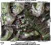
From the trailhead, take the Norton Lakes Trail for one mile following alongside Norton Creek. Shortly before the Norton Lakes Trail turns abruptly east to switchback up a hill, look for an unnmarked, but clear trail heading west through the meadow. Take this newly constructed trail that is not shown on the USGS topo maps one mile to Smoky Lake.
From Smoky Lake, continue one quarter of a mile to the north until reaching Big Lost Lake. Bypass Big Lost Lake on the south to stay on the trail that climbs to a small saddle northeast of the lake. From here, leave the trail and bushwhack up and over Pt. 9,685 to the ridgeline connecting Prairie Creek Peak and Norton Peak. From here, descend to the saddle just northeast of the peak.
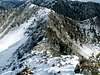
The northeast ridgeline of Prairie Creek Peak is a nightmare of rock outcroppings, towers, stunted growth evergreens, and loose rock. This ridgeline requires good route finding skills and although there are several suitable lines to the summit, it is best to remain on the east side of the ridge where the exposure is least. The first 2/10s of a mile is the worst and most time consuming.
Use a series of ledges and ramps on the east side to bypass any rock outcroppings to difficult to climb up and over. Once closer to the summit, a few more walls block the summit but are easily bypassed. Climbing over them is minimal class IV terrain.
Although this route is rated III and exposure is minimal, it is easy to get ledged up on some difficult terrain. Allow for at least 45 minutes from the saddle to the summit.
 |  |  |
Essential Gear
No essential gear is needed, just good scrambling technique.
Miscellaneous Info
If you have information about this route that doesn't pertain to any of the other sections, please add it here.