
|
|
Route |
|---|---|
|
|
44.94970°N / 118.2029°W |
|
|
Scramble |
|
|
Most of a day |
|
|
Class 2-4 |
|
|
Approach
Follow the directions on the main page under “Getting There” to reach Van Patten Lake.
Route Description
The first step of this route is to ascend the long level ridge immediately west of the lake. This can be done from the lake or from the trail just a little north of the lake. The latter is a gentler climb, but will take longer and the ridge will be less defined. Hiking up from the lake itself is steeper but will put you on a more defined portion of the ridge. If climbing from the lake, go up from the north end because the slopes get much steeper with some small cliffs to the south.
The ridge top itself is basically flat and broad with the only difficulty being dense down/dead trees and monotony. Continue heading south on the ridge, which will eventually become more defined with a rocky top and increase in slope. It is best to keep to the east side as cliffs will soon form to the west. At approximately 8,300 feet elevation, there will be a pronounced abrupt crook in the ridge forming a near vertical northwest facing couloir on the west side.
From this marker, continue on for approximately 5-10 minutes before cutting across from the east to the west side of the ridge. This is a non-descript section where the east side may not seem bad, while the west side looks worse in areas. Still cut over soon because the east side will become impassible. The area to cross is not well defined so it may require a couple stabs at it to find a suitable way. Its just the nature of the ridge. Once in the right area on the west side, the rocks are small, loose and support a stunted whitebark pine forest, while most the west side will be formed of large blocks of granite. Scramble down this slope angling to the left (southwest).
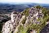
Eventually the ridgeline rocks will become extremely difficult and impassable. Off to the right (west) sheer cliffs will form below. Between these barriers there will be chutes that are not terribly steep and offer reasonable footing on loose rock, soil and heather. Climb these up the slope and parallel to the ridgeline. These paths are not continuous but broken up into sections. Just stay along the base of the ridgeline cliffs and blocks with a little scrambling to keep on the path. This part of the climb will go fast if you stay between the rocks above and cliffs below, but if you get caught in the upper rocks progress will be extremely slow. Soon the ridge will merge into the broad summit ridge. Continue west through the subalpine parkland to the high point, which is formed of large granite rocks on end with huge precipitous drops off the other side. Dense tangled white bark pine make movement around the summit rocks cumbersome.
 |  |  |
Essential Gear
Good hiking boots are all that is required. An ice axe and crampons are recommended for a spring or early summer attempt when snow will be present.
Miscellaneous Info
If you have information about this route that doesn't pertain to any of the other sections, please add it here.