
-
 4390 Hits
-
 76.66% Score
-
 7 Votes
|
|
Route |
|---|---|
|
|
43.08417°N / 110.57038°W |
|
|
Mountaineering |
|
|
Summer |
|
|
Most of a day |
|
|
 NE Ridge route diagram-- click and enlarge for better detail
Overview
This is the standard route on Hoback Peak. More than half of it is on a maintained trail, but this is not a heavily used area, so do not be surprised to encounter deadfall in several places. Also, because of the light usage, the meadows this trail passes through could become so overgrown by late summer that the trail may not be visible. This route is best for late spring and early summer.
Basic Details: Distance to the summit is 5.5 miles with about 3300’ of elevation gain. Difficulty does not have to exceed Class 2. Do not be fooled by the mileage/elevation gain ratio into thinking that it is an easy hike/climb; the elevation gain over the first 3 miles is only about 1000’, and then it’s around 2300’ over the next 2.5 miles.
My source of information for this route was Thomas Turiano’s Select Peaks of Greater Yellowstone. I found his description to be accurate and helpful in regard to both details and distance, with one exception that I will discuss below.
Getting There
A few miles south of the Elkhorn Lodge in Bondurant, almost at the southern end of Bondurant Valley, turn west onto Upper Hoback River Road (there are signs for this and for National Forest access). Follow this road for a little over 6 miles (my trip meter gave me 6.2) and turn right onto Kilgore Creek Road, immediately crossing a cattle guard. When I was here in July 2009, there was no sign marking this road, but it is an obvious, well-traveled road, and as soon as you turn onto it, you will see a small creek (Kilgore Creek, or what's left of it) on your left. Follow this road for a little over 2 miles (I had 2.3, though the Turiano guide-- see More Information-- says 3) to a gate, where a trail (unsigned but easy to locate) heads directly to Kilgore Creek. This is Kilgore Creek Trail and the beginning of the foot approach to Hoback Peak.
Route Description
 Some views along the route...
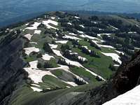 Down the ridge...
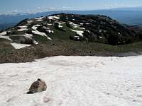 Descent view
The hike along Kilgore Creek Trail begins with a stream crossing. There was a large, solid fallen tree spanning the creek there in July 2009. Should that tree no longer be present, you should expect up to knee-deep conditions in swift, but not raging, water under normal summer circumstances.
There is another stream crossing about a mile later. A short distance downstream, there was a fallen tree spanning the creek, but on the return route, I just forded the creek and found the crossing easy, with the water just knee-deep and only briefly at that. But remember that conditions can vary, so don’t go plunging in just because I wrote here that the crossing was easy.
After the second crossing, the trail becomes mostly boring as it passes through thick forest and climbs a little more moderately.
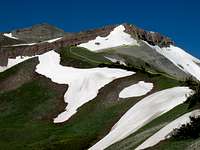
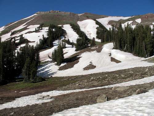
About three miles from the trailhead, the trail breaks into meadows with a view of impressive cliffs and ridges to the south and a high, scenic waterfall directly ahead of and above you. There is supposedly a trail junction around here, but it was not apparent and definitely not signed; a Wyoming resident I’d climbed with the day before had told me he had never seen this intersection.
Continue along the obvious trail, which begins to climb toward the waterfall (soon you see that there are two of them) via some very steep switchbacks. The switchbacks end at a bench overlooking the falls, and the trail leads north along the bench and soon emerges in an open area that is mostly meadows but features more and more talus as you continue north.
Here is where things become a little vague and the guidebook could be a little more specific. The description says to leave the trail and make an ascending traverse back south through a “narrow break in the cliff” (Turiano, Select Peaks… pg. 359).
This was what my climbing partner and I found and did instead-- We could see a goat trail above us and thought, knowing we had to reverse direction eventually, that the trail would lead to its lower end. We were wrong. It soon became apparent that the trail was continuing north to a saddle just east of an arm of the mountain (this arm is part of the NE ridge, but this spot is far from where you want to gain the ridge) and from the saddle to points north.
So we turned around and began to climb until we found our way into the upper basin that accesses the summit area. The goat paths we found helped. I never felt that we went through a “narrow break in the cliff”; instead, we just kept climbing and traversing until we got to easier terrain and the upper basin.
Here is what is essential to know: if you aim for the waterfall and stay just to its right as you face it, you will find your way through the cliffs and into the upper basin one way or another.
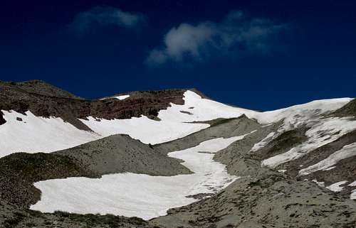
Once up there, hike up the basin, which is mostly wide open and delightfully free of bushwhacking. You should generally be following Kilgore Creek, and as you near its head, choose your way to the crest of the northeast ridge. A broad saddle at just under 10,000’ seems like the best destination.
From the saddle, the summit is about three fourths of a mile away, and the remaining elevation gain is about 900’. Two peaks are visible, but neither is the true summit. The route will take you to the top of the peak on the right.
Grassy slopes give way to dirt, and there is a short, very steep section just below what seems to be the top that may require the use of hands for balance or purchase, especially if you are tired. Finally, you reach the top of the peak you’ve been constantly checking on, and you find that it’s not the summit. Turn right and hike less than a tenth of a mile, gaining only about 25’ of elevation, to the real summit.
Variations
 V1-- North face
1-- When there is a lot of snow in the upper basin, as there was on July 5, 2009, it is possible to take a more direct route to the summit by climbing the snow through a moraine-like area on the peak’s steep north face. We used this as a descent route. Except for the beginning of the descent, where the snow briefly was very steep, the slopes were mostly moderate and easy. We also found the snow to be mostly very soft in the late-morning sun and never pulled out our ice axes. If you do use this as a descent, be wary of picking up too fast a pace on that soft snow; if you posthole when doing so, you could easily break a leg.
2-- Once you reach the upper basin of Kilgore Creek, scramble to gain the crest of the southeast ridge and follow it over or past some minor summits to the real summit.
 V2-- SE Ridge
Topo Map
