
-
 22928 Hits
-
 89.01% Score
-
 28 Votes
|
|
Mountain/Rock |
|---|---|
|
|
43.08417°N / 110.57038°W |
|
|
Mountaineering |
|
|
Summer |
|
|
10862 ft / 3311 m |
|
|

Overview
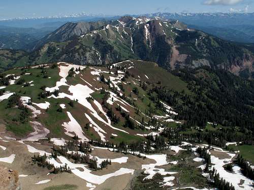
Most of the Wyoming Range consists of a series of hogback ridges-- put very briefly, simply, and probably inadequately, hogbacks are upthrusts that fall steeply, with almost identical grades, on two opposite sides-- and the peaks are highpoints along those ridges. This explains why the Wyoming Range can look so sheer from the east or the west but in many places seems like a series of rolling hills from the crest of the range.
Hoback Peak is one of a few exceptions. It is a massive mountain that presents steep faces on all sides, and although the easiest routes up the peak are only Class 2, those routes involve long, indirect approaches along ridges. According to Thomas Turiano (see the “More Information” section), the mountain has more vertical rise from its defining saddles than does any other peak in the Wyoming Overthrust Belt (which includes the Wyoming and Salt River Ranges). Turiano also writes that the peak “blossomed like a flower from localized thrust faults on three sides” and “is shaped like a starfish with four arms radiating from the focal point at the summit” (Turiano, Select Peaks of Greater Yellowstone, pg. 358). The “arms” are the northeast, northwest, southeast, and southwest ridges.
Hoback Peak is sometimes mentioned as the highpoint of the Hoback Range. That range is part of the larger Wyoming Range and is in the northeastern section of the parent range.
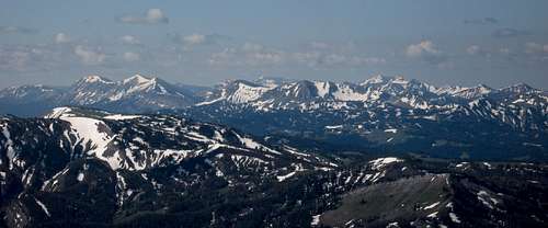
Views from the summit are exceptionally good since Hoback Peak is one of the highest points of the Wyoming Range and does not have a higher neighbor for many miles. Triple Peak, the nearest Wyoming Range peak that is higher, is about 20 miles to the south, and there are no higher range peaks in any other direction.
Looking north, one can easily pick out many of the major peaks of the Teton Range, including the world-famous Grand Teton. Northeast and east, respectively, the Gros Ventre Range and the Wind River Range scream to be seen; Gannett Peak, Wyoming’s highest mountain, is there to remind you of its status. Turning south, one sees the best of the Wyoming Range, including Mount McDougal, Triple Peak, Mount Coffin, and Wyoming Peak (the range's highest). To the west, there is more of the Wyoming Range, namely Grayback Ridge, and the Salt River Range beyond. Past the Salt River Range, the flat expanses visible are part of the plains of Idaho.
Hoback?
There are at least seven places in Wyoming bearing the name Hoback. I know of four: Hoback River, Hoback Canyon, Hoback Junction, and, of course, Hoback Peak.
So who or what was Hoback?
In July 1877, Allen D. Wilson, a geographer for the Hayden Survey, became the first recorded climber of Hoback Peak. Wilson and Henry Gannett (yes, of Gannett Peak fame) named the peak for John Hoback.
Hoback was a trapper who set off with two other men to explore the southern and central parts of what is now called the Greater Yellowstone Ecosystem. Not much else is known today about the man, and it is unclear from the sources I found whether he ever climbed the peak named for him; it seems, by omission, that he did not.
Turiano's book was the source of most of the above information concerning John Hoback, but I also found some information, not directly recounted on this page, on this site.
Solitude
Of the major ranges in the Greater Yellowstone Ecosystem, the Wyoming Range probably sees the least human traffic. No paved roads penetrate the range. There are no national parks, though much of the range did gain wilderness status when President Barack Obama signed the Omnibus Public Land Management Act in May 2009. Many east-side trailheads are far from large population centers. The west-side trailheads are even more remote, accessed by the long, unpaved, and highly scenic Greys River Road that runs south from Alpine to Tri-Basin Divide. The range itself, like the Salt River Range that runs parallel to it to the west, is more an extension of the vast ecosystem than one of the core ranges that encircle Yellowstone National Park.
People who "discover" this range tend to fall in love with it for the red cliffs, the expanses of open terrain, the wildflower meadows, the remoteness, the relative emptiness (of people), and more. It is not as wild or pristine as the ranges in the heart of the ecosystem are, but its beauty and opportunities for exploring and solitude amply make up for that.
At the summit of Hoback Peak, there is a cairn, but, typical of Wyoming peaks, there is no register. The peak is hardly unknown, but most climbers of this peak are Jackson- and Pinedale-area residents, and they number in the relative few. Remember-- probably because there is no trail to the top and it is a long drive from the closest large town, a big, significant peak like this one just is not going to draw the crowds.
If there were a register and every climber signed it, I am willing to bet that the number of entries for one year would not match the number of entries in the register atop the Grand Teton (if there is a register) for just the month of June, July, or August.
A trophy peak for hero shots and stories repeated over beers? Not at all. A remote peak in a setting that is what most of Wyoming is all about? Oh yes.

Getting There
A few miles south of the Elkhorn Lodge in Bondurant, almost at the southern end of Bondurant Valley, turn west onto Upper Hoback River Road (there are signs for this and for National Forest access). Follow this road for a little over 6 miles (my trip meter gave me 6.2) and turn right onto Kilgore Creek Road, immediately crossing a cattle guard. When I was here in July 2009, there was no sign marking this road, but it is an obvious, well-traveled road, and as soon as you turn onto it, you will see a small creek (Kilgore Creek, or what's left of it) on your left. Follow this road for a little over 2 miles (I had 2.3, though the Turiano guide-- see More Information-- says 3) to a gate, where a trail (unsigned but easy to locate) heads directly to Kilgore Creek. This is Kilgore Creek Trail and the beginning of the foot approach to Hoback Peak.

Routes Overview
Most people interested in climbing Hoback Peak are going to want to try the northeast ridge because it involves the shortest approach and has a maintained trail for a little more than half of the route. Another feasible route is along the northwest ridge via Cliff Creek Pass; that route will require at least one night, probably two, of backcountry camping. Yet another route could be along the southwest ridge via Roosevelt Meadows (another backpacking outing; USGS maps show a trail crossing the meadows, but it is anyone’s guess about the trail’s conditions or even existence since this is a remote area that does not receive high-priority trail maintenance. It is also possible to climb the peak via the southeast ridge as a variation of the standard approach; the topo map and one of the pictures displayed on the attached route page illustrate that possibility.
Please see the attached route page for detailed information about the NE Ridge route, considered the standard route on Hoback Peak.
Red Tape
No fees, no permits.
If you are out here in the fall, take precautions due to its being hunting season.
It is not official that grizzlies have returned to the Wyoming Range, but there are rumors of them. Know your grizzly etiquette. There are definitely black bears, so don't forget to store food properly and that these bears, though overshadowed in this part of the country by the mighty grizzly, are easily capable of killing you. Another animal to be wary of is the moose, especially a bull in rutting season (fall) or a cow with a calf. Many people don't realize this, but a protective mother moose is one of the most dangerous animals you can ever encounter; some Montana and Wyoming residents fear/respect them even more than they do the grizzlies.
Camping and Lodging
Almost all of the land adjacent to Upper Hoback River Road is private property-- ranches and some exclusive clusters of trophy homes-- and there are no camping options along the way. Most of the land adjacent to Kilgore Creek Road seems to be Forest Service Land, but there are no developed campgrounds. The best camping area seems to be at the trailhead at the end of the road.
Just beyond the turnoff for Kilgore Creek is The Lodge at Jackson Fork. Primarily a destination for anglers, it might appeal to people spending several days in the area.
More Information
Bridger-Teton National Forest
Hoback Peak is on the border of the Greys River and Big Piney Ranger Districts. The approach from Kilgore Creek is in the Big Piney Ranger District. If you take a backpacking approach via Cliff Creek Pass, you may be starting in and passing through either or both districts.
Thomas Turiano's Select Peaks of Greater Yellowstone was my source of information on this peak before I climbed it. His entry for Hoback Peak contains additional geological and historical information that this page does not cover, and it also discusses some backcountry skiing routes on the peak.
