
|
|
Route |
|---|---|
|
|
38.95417°N / 106.497°W |
|
|
Mountaineering |
|
|
Summer |
|
|
Most of a day |
|
|
Hike |
|
|
Getting There
The trailhead for Sheep Rock Mountain is the same as the trailhead for Huron Peak. From Buena Vista, drive 15 mile north (or 19 miles south from Leadville) to Clear Creek Reservoir Road (County Road 390). Drive Clear Creek Reservoir Road 11.7 miles to reach the ghost town of Winfield (this is a dirt road passable by most/any car). In Winfield, turn left and cross the bridge to reach a parking area. You might see signs for Huron Peak Trail. If you have 4WD, you can drive another 2 miles to the end of the roadRoute Description
All distances are per my GPSAt the 2WD Trailhead, you might see signs for Huron Peak or Lake Ann. Head south and hike the 4WD Road through a forest (In 2 miles the road goes up only 300 ft). The forest will soon end and you will reach a meadow where Granite Mountain appears to the south. Before reaching the end of the road (Huron Peak Trailhead), at an unsigned intersection, you will see a spur road heading west toward Clear Creek. Another road heads east toward a number of abandoned shacks (Banker Mine). The GPS Coordinates for this intersection are:
38 57.242 North
106 28.650 West
Turn west and hike the spur road until it reaches Clear Creek. You will have to cross to the west side of the creek here (in mid August 2011 the creek was wide, shallow and easy to cross).
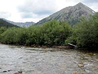
Stream & Granite Mtn
After crossing the creek, I did not see a road but I did see a beaten path in the grass. I followed it and it turned into an abandoned 4WD road that was overgrown with grass and small trees. The “road” was generally easy to follow but it helps to study the USGS Map to become familiar with the path of the road. If you are not careful, at some switchbacks, you might lose the “road”.
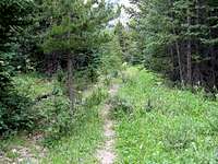
Overgrown Road
You will have good views of the Three Apostles.

Apostles
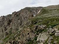
As you keep going, Sheep Rock Mountain comes to view for the first time (and later goes out of view).
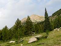
Sheep Rock Mountain
Follow the “road” to the end of it at 11250 ft. You will have to study your map and find your own way after this. I went straight up the slopes which were at first steep but then became better. The path that I took, went over slopes with patchy forest so the bushwhacking was not bad.
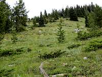
Going Above Treeline
Sheep Rock Mountain appears to the west. Follow any path to reach an alpine bowl surrounded by Sheep Rock, West Virginia and Virginia Peaks.

Sheep Rock
You can then go up the northeastern slopes of Sheep Rock to reach its summit.
Summit