
|
|
Route |
|---|---|
|
|
38.84060°N / 105.0439°W |
|
|
hike/snow hike |
|
|
Most of a day |
|
|
Class 2 walkup |
|
|
Approach
Use the Crags Campground TH (10,100 ft). In winter and early spring the snow closure will be about 2 miles earlier and 500 vertical feet lower.
Route Description
This is a good option for a snow route on Pikes Peak. After the Pikes Peak road opens it isn't so good because it follows the road part of the way. Hikers are not allowed to walk on the road but there is a climbers trail off to the side.
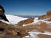
With snow this would be a long day especially with a snow closure. Consider backpacking up to the Devils Playground. Just be prepared to melt snow for water and potentially high winds. This is a particularily bad place during a thunderstorm. Lightning is known to strike the crags of the Devil's Playground and jump around from rock to rock.
Start on the Crags Trail from the Crags campground. After several hundred feet the trail passes to the right of 3 metal pipes. Pay attention because shortly after this the route leaves the Crags Trail by peeling away to the right and crossing a stream. Follow the obvious trail (old road at first) through the woods to treeline (11,800 ft).
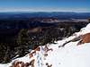
In snow continue climbing upwards as the footprints and avalanche prudence dictates. Once you crest the flats and can see the Devils Playground set up camp there if you are overnighting.
After the snow melts continue upward following a climbers trail.
At the Devil's Playground get on another obvious old road and follow it to the Pikes Peak Road. If PPR is closed simply hike it to under the truncated summit cone. If the road is open you will need to find the climbers trail to stay legal. Follow the trail to under the truncated summit cone. At the bottom (13,400 ft), climb up through the jumbled blocks by following the cairns when you can. Eventually you'll make it to the summit parking lot. Stroll around and find a couple high spots to stand on. The actual highpoint is difficult to identify.
Descend the ascent route or if the road is closed leave the summit via the PPR's switchbacks.
 |  |
Essential Gear
In summer one's standard hiking gear will suffice. With snow consider snowshoes or skis and poles. You should not need and ax or crampons for spring and probably not for winter either.
 |  |
Miscellaneous Info
If you have information about this route that doesn't pertain to any of the other sections, please add it here.
Sarah Simon - Oct 2, 2010 10:34 pm - Hasn't voted
New TrailheadThe Forest Service has built a new trailhead less than 1/2 mile downhill from the campground. (Unless folks are camping at the Crags Campground), they want day-hikers to use the new parking area. Cheers, Sarah