
-
 56636 Hits
-
 90.06% Score
-
 31 Votes
|
|
Route |
|---|---|
|
|
45.93664°N / 7.86802°E |
|
|
Mountaineering |
|
|
Summer |
|
|
A few days |
|
|
II+, PD+, 40 degrees (strenuous) |
|
|
OVERVIEW
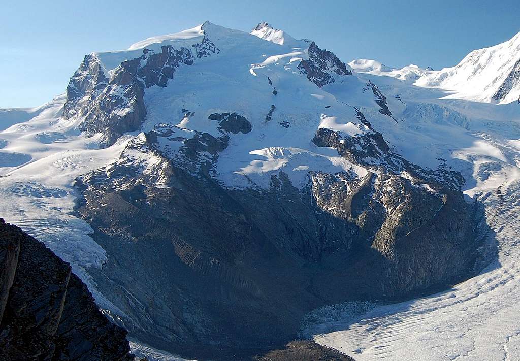
Swiss side of Monte Rosa - with Nordend 4609m and Dufourspitze 4634m
This page was initially written by Tom Fralich in 2001. Tom kindly passed ownership on to myself March 2014 and with the benefit of recent as well as past experience of Monte Rosa, I have completely revised the page and added a lot of new material and photos.
At 4634m (15,203ft) the Dufourspitze is the highest of the eight 4 thousand metre summits of the Monte Rosa massif. It is also the highest summit in Switzerland and 2nd highest in Western Europe, after Mont Blanc 4810m (15,780ft). First ascent was on 1st August 1855, via NW flank and West Ridge - now 'Swiss Normal Route' - by a large party including C.Hudson, J.Birbeck, C.Smith, J. Smyth, E.Stevenson, U.Lauener, J &M. Zumtangwald.
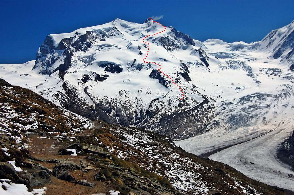
The startlingly airy summit crest of the Dufourspitze is one of the finest places in the Alps to visit and commands quite extraordinary views in all directions. Despite this attraction, it is visited far less frequently than Mont Blanc. Most who do visit, reach it via the Swiss Normal Route – ascending the laborious NW Flank, before ascending the airy crest of the West Ridge to the summit. The route is long and involves a substantial increase in altitude from the new Monte Rosa Hut at 2883m – to the summit at 4634m. Much of this 1751m of ascent involves an arduous trudge up the vast glacial sprawl of the NW flank, weaving round crevasses and up over snowy hummocks. Much of this part of the route will need to be climbed in the dark, chill hours before dawn. The reward is the sunrise seen from high on this vast mountain, followed by final 275m of airy and exposed west ridge up to the summit
This impressive finish is mildly technical and is what gives the route an overall grade of PD+.
The Swiss Normal Route is very strenuous – and it reaches the substantial elevation of 4634m/15,203ft. Not only is a high standard of fitness required to complete this route comfortably, but also good acclimatisation: it would be unwise to attempt this climb without at least a couple of nights at altitudes of between 2800-3000m - and a prior ascent to at least 4000m.
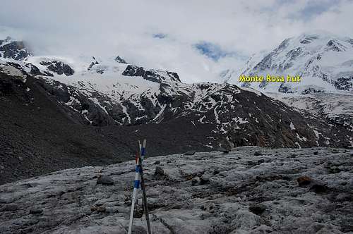
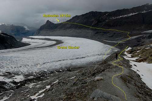
One of the greatest changes to this route in recent years has been the opening of the new Monte Rosa Hut at 2883m in 2009. This 5 storey silver construction involves state of the art technology and at 2883m is situated 88m higher than the old Betemps Hut, at 2795m. Access to the new hut is still via the Gornergrat railway and the penultimate stop at Rotenboden 2815m - and involves an initial 300m descent to the massive confluence of the Gorner and Grenz Glaciers, before climbing up to the hut.
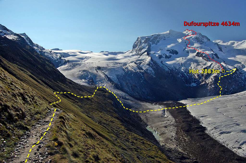
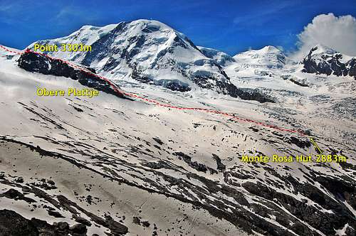
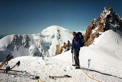
View of entire route from just below Rotenboden
VALLEY BASE - ZERMATT
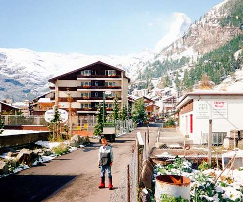
Zermatt in 1992 - Bahnhof Hotel behind
Zermatt is an historic and famous Swiss town nestling at the foot of the greatest collection of 4000m peaks in the Alps – and at the head of the Mattertal Valley. The skyline is dominated by the famous Matterhorn, which is actually a lesser cousin to Monte Rosa - being some 156m lower.
The Monte Rosa Massif is too far back to be visible from Zermatt. Nonetheless, the town is the main access to the north-west aspect of Dufourspitze and the Swiss Normal Route.
Being ‘car-free’ Zermatt is accessed mainly by 6km cog rail-way shuttle service from Tasch – but can also be accessed by a taxi minibus service with drop-off at outside of the town. (Click)For details of car-parking and shuttle service see link: Zermatt parking & shuttle
Tasch can be easily accessed by road and rail links with Visp, in the Rhone Valley. Beyond the far end of the Rhone Valley, Geneva is the nearest airport link – and is about 230km from Tasch.
Accomodation
Camping is available at Randa, Tasch and Zermatt.
Budget accommodation is available at the historic Bahnhof Hotel, Zermatt
APPROACH
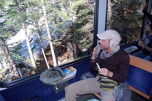
Rob G on Gornergrat Railway
Zermatt 1600m to new Monte Rosa Hut 2883m
Take Gornergrat cog railway to the penultimate stop at Rotenboden 2815m. From here a signed path heads ESE in a descending traverse towards the vast Gorner Glacier. The final descent to the glacier has varied over the years according to the state of the ice, but as of 2013 involved down-climbing steep slabs using ladders and chains – and finally crossing a small metal bridge to reach the ice at about 2500m.
From here – again, the route has varied over the years - but can be expected to be clearly marked with a variety of markers. As of 2013, the route crossed the junction of the Gorner and Grenz Glaciers over a chaotic jumble of medial moraine, before following east bank of the Grenz Glacier now – weaving around wide crevasses. The route leaves the ice and after a short scramble across moraine, ascends a clearly marked trail, initially up rock slabs, but then lateral moraine crest to the silver construction of the new Monte Rosa Hut at 2883m. About 3 hours from Rotenboden.
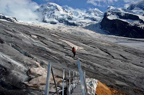
Bridge across to the ice at 2500m
Crossing the big glacier with Monte Rosa Hut up ahead
NEW MONTE ROSA HUT
As above, the new Monte Rosa Hut (link is to an excellent SP page by andrea.it) is a state of the art mountain dwelling opened in 2009, at a site 88m higher than that of the old Betemps Hut. It is a silver coloured ‘environmentally friendly’ 5 story structure, which runs on solar power.
Tel +41(0)27 967 2115. For website and on-line booking click on: Monte Rosa Hut booking
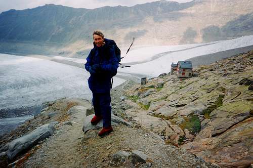
Alan G in 1992 with the old Betemps Hut at 2795m behind
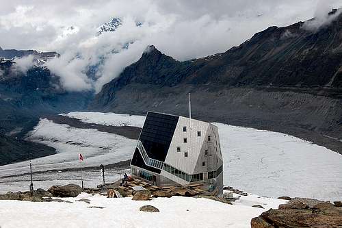
The new state of the art Monte Rosa Hut at 2883m, July 2013
THE ROUTE
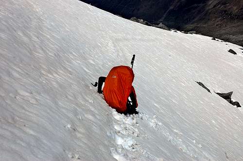
NW Flank
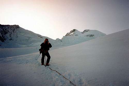
The lower section of the route - climbed in the dark
The entire route above the Hut
From the new Monte Rosa Hut ascend moraine followed by a cairned trail through a boulder field – up to the edge of Monte Rosa Glacier near to Point 3303m. This section will take about 1 ½ hours and will need to be ascended in the dark, by torch-light - to ensure a timely descent, before afternoon deterioration in snow conditions on the glacier. It is thus worth taking the time to reconnoitre this part of the route the day before, if time permits. The original author of this page, Tom F, suggested climbing the route to at least 300m above the hut - which makes good sense.
When I climbed this route in 1992, I got round this problem by carrying up a tent, passing the then Betemps Hut at 2795m - and camping amongst the rocks of the Obere Plattje at over 3000m.
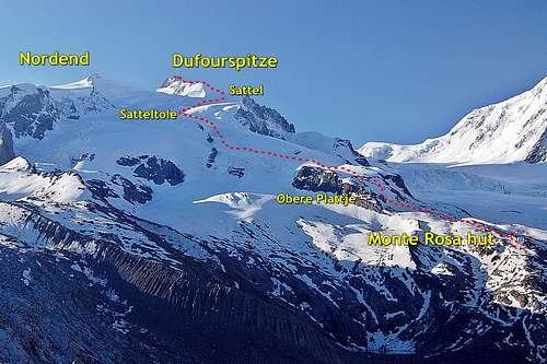
Once on the glacier the route follows an undulating course, but initially bearing towards the left and a crevasse field – which leads to a hollow to the right of the rock rognon at Point 3827m. This island of rock is passed on the right (heading south). Not far from here is a steepening at the ‘Schole’ and the route to the Silversattel and Nordend peels off to the left – (if a trail is visible - this route is less frequented). Next and at around 4000m another hollow is reached – about 3-4 hours out from the hut - and illuminated by now by the golden rays of early sunrise. This is called the Satteltole and is followed by a final steep rise to the col known as ‘Sattel’ at 4359m – reached after about another hour plus; so around 5 hours out from the hut.
High on the glacier - near to the Satteltole, at around 4000m
Crevassed zone high on glacier soon after sunrise
It is worth noting that early in 2013 season people were reporting difficulties crossing the bergschrund just below the Sattel. This didn’t stop access to the summit. However, this problem could be expected to worsen towards the end of the season – and should be born in mind with any plans to climb the route much beyond the end of August.
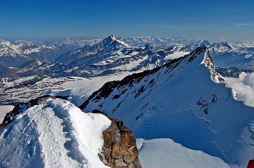
The West Ridge
Alan G at the Sattel 4359m, in late September 1992
At the Sattel at 4359m there is now a very impressive view of the sharp crest of the West Ridge. After hours of slogging by torch-light over the weary undulations of the huge glacier behind, the sight is quite startling - and certainly formidable.
The West ridge is in two sections: an initial ice crest and some mixed ground leads up to a hump on the ridge at 4499m. This is followed by another little col, just visible from below. Then the next and final section rears up even more startlingly - in a great white spire - which looks to terminate at the summit. However, out of sight is even more mixed ground with some fairly tricky rock at the grade of II, but with one awkward little chimney graded III, but protected by a bit of fixed rope. The views and exposure in this section are impressive.
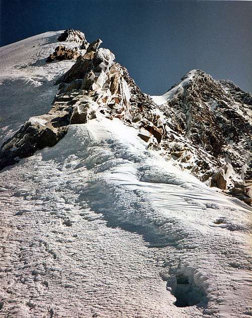
The fearsome West Ridge from the Sattel - little col just visible
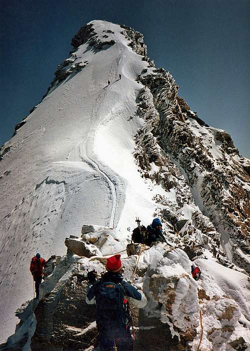
(Nearly) the top, from the col half way up the West Ridge
Finally the summit is reached - about 6-7 hours from the Monte Rosa Hut.
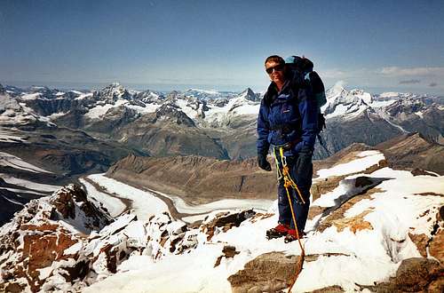
THE SUMMIT
Alan G on the top of Dufourspitze in late September 1992
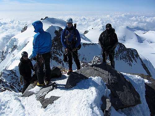
Four on the summit 7th June 2013 - the 5th (rgg: photo) dangling over the void...
The summit of the Dufourspitze is very small – with room for about four to share comfortably - with five, in July 2013, it was a trifle tight - and someone was in danger of being squeezed over the edge, into the void. In the RH photo above, which I have shamelessly stolen from rgg, the man himself was backed up onto the narrow crest leading onto the top - and in danger of making an unscheduled visit to the upper Monte Rosa Glacier 500m below. With Alan G in LH photo it was the end of September 1992 and we had the place to ourselves.
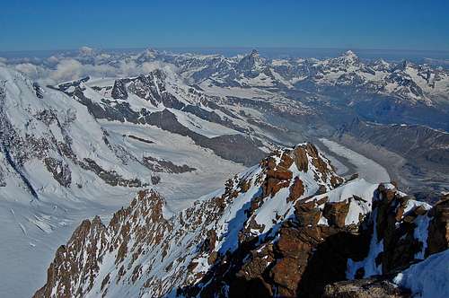
The view from the highest place in Switzerland is fabulous in all directions. Just about every 4000m peak in the Alps is visible on a clear day. The only higher summit in the view is the great bulk of Mont Blanc, about 70 miles away on the far horizon to the west.
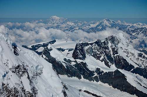
The only higher summit in view is the distant bulk of Mont Blanc 176m higher
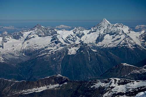
Zinal Rothorn 4221m and the elegant spire of the Weisshorn 4506m
DESCENT
Reversal of the normal route.
Care is needed descending the exposed crest back down to the Sattel. With the fatigue of the early start compounded by 1800m ascent, a lapse of concentration is possible - and this would be a bad place to trip over a crampon. The long weary descent down the upper Monte Rosa Glacier is more straight forward – but crevasse danger means that nevertheless a high degree of vigilance needs to be maintained - and it is to be recommended that this long section be completed by around 1pm – to avoid escalating risks posed by softening snow bridges in the mid to late afternoon sun.
Looking back down Swiss Normal Route from summit
Time from summit back to Monte Rosa Hut approximately 4 hours.
If continuing on down beyond the Monte Rosa Hut back to Rotenboden and the Gornergrat Railway the same day, it is worth remembering that this stage will take 2-3 hours - and includes what by then will be a very unwelcome 300m ascent back up from the Gorner Glacier. It is advisable to have noted the time of the last Gornergrat train as it stops at Rotenboden, en route for Zermatt.
Return from Monte Rosa Hut to Rotboden - showing the unwelcome 300m ascent
Traverses of Monte Rosa
With excellent acclimatisation and sound knowledge of current route conditions there are two options for continuing on beyond the Dufourspitze summit to complete a traverse of Monte Rosa:
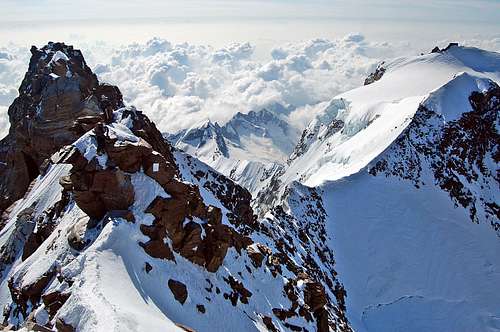
1) Traverse to Nordend 4609m: having continued for about 120m, almost to the Italian top of the Grenzgipfel, there is an AD route (protected by fixed ropes) down to the Silversattel – and then via a PD+ route up to the Nordend. It then possible to descend to re-join the NW Flank route below the Satteltole – and from there back down to the Monte Rosa hut. Time from Dufourspitze to Nordend 1-2 hours - and then around 4 hours to descend to Monte Rosa Hut. With the initial 6-7 hour ascent of Dufourspitze this would make for a very long day - especially if intending to make it back to Rotboden. (14-16 hours total).
Nordend 4609m viewed from Dufourspitze summit July 2013 4634m
2) Traverse to Signalkuppe 4554m: this is a reversal of the Italian Normal Route (SP route page). In brief, traverse along AD- crest to the top of Grenzgipfel, past the descent to the Silversattel. The route then drops down sharply to the SE – at AD standard – to the Grenzsattel, up over Zumsteinspitze and thence over easier ground to the Signalkuppe – and the Margherita Hut. About 3 hours from Dufourspitze to the Signalkuppe. Most would elect to spend the night at the Margherita Hut, right on the summit, before descending from there either back down the Grenz Glacier to Switzerland - or down the Lis Glacier into Italy.
Traverse to Signalkuppe 4554m via Grenzsattel & Zumsteinspitze 4563m
WHEN TO GO
Seasons are increasingly difficult to predict with certainty. Summer climbing season may start as early as June - but huts don't open until beginning of July - and early attempts on glacier routes like NW Flank of Monte Rosa may require use of snow-shoes or skis. I feel sure seasons seemed to extend on well into September in the past. Indeed, first time I climbed Monte Rosa was around 30th September in 1992... However, these days many glaciers seem to have become impassable due to exposed crevasses long before then - and huts are often closing by the middle of the month.
The optimum months for summer alpinism are thus July and August. But there still can be no guarantee...
In 2013, July 3rd was a little too early to be on Monte Rosa...
REDTAPE
Common sense rules apply in terms of respecting the environment. No permits are required nor registration with any organisation - but it makes good sense to leave word of your intentions in the mountains at the huts etc. Alpine Club Membership may give discounted rates at some but not all Alpine Huts - suggest check relevant websites.
EQUIPMENT
Normal alpine attire – but including duvet jacket, in deference to the very high altitude and potential for extreme cold - and including good protection for hands, feet and eyes.
Ice-axe and crampons.
Standard glacier equipment: harnesses, prussic loops, slings with karabiners - and a rope.
A couple of slings per pair are adequate for the little bit of rock-climbing on the West Ridge – but some may wish to carry an additional small selection of rock gear, according to personal preference.
Miscellaneous items such as First Aid Kit, Map, Compass – and GPS for devotees of such devices
EXTERNAL LINKS/GUIDES
Guide books:
(UK) Alpine Club. "The 4000m Peaks of the Alps - selected climbs" revised 2012. Author: Martin Moran
"The Alpine 4000m Peaks by the Classic Routes" revised 2006. Author: Richard Goedeke.
"Gebietsführer Walliser Alpen", by Marianne Bauer and Michael Waeber, fully revised 14th edition, 2012. In German.
Maps:
Swiss
1: 50000(large edition) No 5006 Matterhorn-Mischabel
1:25000 No 1348 Zermatt
Italian
IGC 1:50000 Cervino - Matterhorn (5); Monte Rosa (10)
IGC 1:25000 Cervino - Matterhorn (108); Monte Rosa (109)
Links:
Dufourspitze - Swiss Normal Route
Happy climbing - and stay safe!
selinunte01 - Aug 13, 2016 8:37 am - Voted 10/10
New routesPlease note the following route changes and information (august 2016): Ascent to new Monte Rosa hut: Coming from Rotenboden descend to Gornergletscher (2016: woodbridge over the bergschrund); follow the route marked with red wooden poles descending the Gornergletscher to the middle moraine between Gorner and Grenzgletscher. Traverse the middle moraine zone - this one changes every year! - to the rim of the Grenzgletscher. The new ascent route barely touches the rim of Grenzgletscher and heads for the moraine zone east of Grenzgletscher, ascending to the glacier lake (point 2599 m on swiss topo maps). It continues up the ridge northwest of new Monte Rosa Hütte up to the hut and is markes with blue dots and arrows. Don´t use the old route, traversing Grenzgletscher up to 2640 m and ascending the slabs and polished bedrocks by means of ropes and iron cramps. These securings are no longer maintained! Ascend from new Monte Rosa Hütte: 1. The route between Monte Rosa Hütte and Obere Plattje (glacier rim) is now marked with red wood poles and blue dots / arrows and sometimes blue "D"´s. The route uses now the moraine zone and no longer the polished bedrocks between Untere and Obere Plattje. The latter is now water protection zone so please follow the new marks! 2. Normally the descent from Dufourspitze is via the north chute down to Silbersattel with the help of fixed ropes. By doing so you avoid two-way-traffic on the west arete of Dufourspitze which really can be a pain in the ..... In August 2016 there was a rock slide in the chute area and the ropes were damaged. The zone is still dangerous. Please ask the hut staff for actual information.
markhallam - Aug 13, 2016 11:21 am - Hasn't voted
Re: New routesThanks for this. Big glaciers and mountains do have a habit of changing...
AlpineTrails - Aug 25, 2016 11:12 am - Voted 10/10
No more fixed ropes!!August 2016: On the ascent, there are is no more fixed rope on the chimney before the summit. On the descent: The fixed rope down to Silbersattel has been cut. If you plan to abseil make sure you have enough rope with you.