
-
 34019 Hits
-
 88.19% Score
-
 26 Votes
|
|
Route |
|---|---|
|
|
45.93684°N / 7.86701°E |
|
|
Mountaineering |
|
|
Summer |
|
|
One to two days |
|
|
Assez Difficile |
|
|
5.3 (YDS) |
|
|
III |
|
|
OVERVIEW
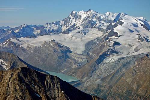
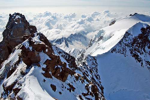
Monte Rosa from Weissmies summit September 2009. Italian Normal Route traverses skyline L to R.
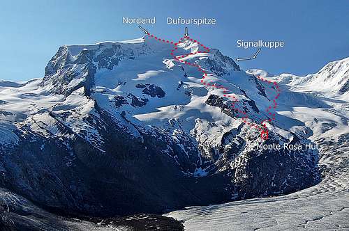
At 4634m (15,203ft) the Dufourspitze is the highest of the 8 four thousand metre tops of the Monte Rosa Massif. It is also the highest peak in Switzerland and summit of the 2nd highest mountain in Western Europe, after Mont Blanc 4810m (15,780ft). The startlingly airy summit crest of the Dufourspitze is one of the finest places in the Alps to visit and commands quite extraordinary views in all directions. Despite this attraction, it is visited far less frequently than Mont Blanc – and most who do visit, reach it via the Swiss Normal Route, which ascends the long and laborious NW Flank, before the more interesting finish of the West Ridge.
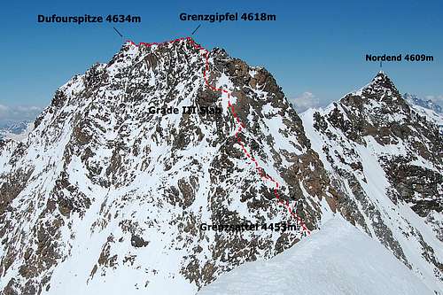
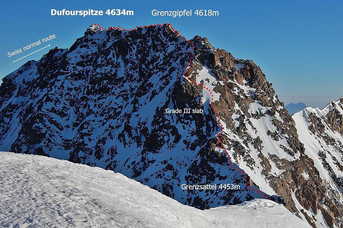
The South-East Ridge or ‘Italian Normal Route’ is used much less frequently. Graded AD, it is a little harder than the Swiss route (PD+). It is also much more complex to access. For most the route involves a high altitude traverse from the summit of the Signalkuppe (4554m), over the Zumsteinspitze (4563m) and then down to the Grenzsattel (4453m) before the ridge is reached. It is then climbed to the rocky ‘Italian summit’ of the Grenzgipfel (4618m). The higher ‘Swiss summit’ of the Dufourspitze (4634m) is another 130m away, along a sensationally exposed rocky crest – graded at AD minus.
The Margherita Hut is located at the summit of the Signalkuppe – and for most this is starting point for the Italian Normal Route. At an altitude of 4554m this is the highest mountain hut in the Alps. It is a worthy objective just in itself – and the only approaches are via long graded alpine routes. The most straight forward of these is from Italy; a 4 ½ hour glacier ascent from Gnifetti Hut (3611m) graded F. Alternatively, it may be accessed via the mighty Grenz Glacier and a longer (6-7 hour) ascent from the Monte Rosa Hut (2883m) on the Swiss side, at the grade of PD minus. The only other routes to the Signalkuppe are via the ferocious east face – and graded D and above.
Recommended Expedition: Whilst the glacier ascent from Gnifetti to Margherita Huts, described above, is the shortest route of approach – aesthetically, it makes for a rather splendid day out to include 4-6 of the intermediate 4000m tops along the way. This constitutes the “Traverse of the Tops” as described in the (UK) Alpine Club Guide, written by Martin Moran. This raises technical grade to PD+ and extends duration of the ascent to up to 6 ½ hours.
Dufourspitze SE Ridge may be followed in either direction. It may be ascended, as above, as the ‘Italian Normal Route’ to the highest point in Switzerland. Alternatively it may be descended as part of one of two possible traverses of Monte Rosa:
- Ascent of Dufourspitze via Swiss normal route followed by traverse to Signalkuppe.
- Ascent of Nordend (4609m) followed by traverse to Dufourspitze, then by traverse to Signalkuppe.
Either constitutes a fine expedition, especially the route taking in the Nordend – 2nd highest of the Monte Rosa summits, after the Dufourspitze. However, it should be noted that there is an element of seriousness about both routes, both of which involve descent of the SE Ridge. In effect, this means that the technically hardest part of both expeditions must be covered in descent – and on ‘un-seen’ terrain.
Conditions on the SE Ridge can become very dangerous, even when the other routes are still in good condition. It should go without saying that current conditions should be researched thoroughly before even thinking of committing to this traverse – and parties need to be fit, well acclimatised and very competent at down-climbing tricky terrain.
The SE Ridge can be expected to take about 3 ½ hours in either direction – in average conditions. Bypassing the Signalkuppe and ascending all the way from the Gnifetti Hut adds about 4 hours to the expedition – a very long day. Starting the ascent at the more intermediate Balmenhorn Bivouac Hut (4167m) would halve this time to an additional 2 hours – but still quite a long ascent at potentially 5-6 hours hut to summit
Margherita Hut - right on the summit of Signalkuppe, at 4556m
Dufourspitze Italian Normal Route - looking across from Zumsteinspitze
FIRST ASCENT
Monte Rosa was first climbed from Zermatt, on the Swiss side, in 1855.
The first recorded ascent of the Italian Normal Route via SE Ridge was 31st August 1874 – by F.P. Barlow and G.W. Prothero with guides Antonio Carrel and Peter Taugwalder. This was some 19 years before Margherita Hut was first built on summit of the Signalkuppe. Details as to exactly where this party started their ascent seem to have been lost in the mists of time.
VALLEY BASES
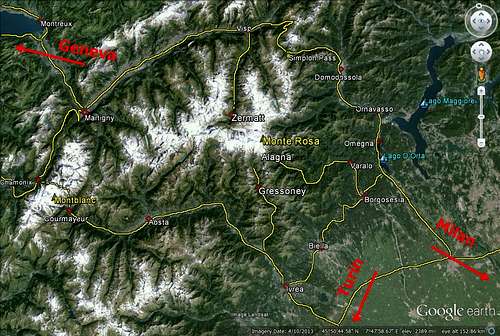
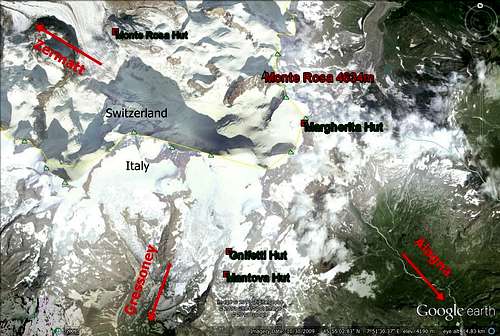
Dufourspitze SE ridge can be approached from Zermatt, on the Swiss side – or Alagna Valsesia and Gressoney-La-Trinité , on the Italian side. It is 13km from Zermatt to the summit as the crow flies, but just 10km from Alagna. Gressoney is a little further, at around 17km.
Monte Rosa region - road connections on Google Earth
SWISS SIDE: ZERMATT
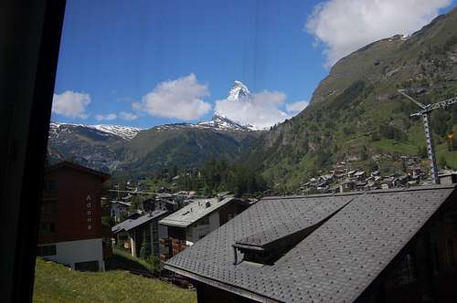
Zermatt from Gornergrat railway
Zermatt is a historic Swiss town nestling at the foot of the greatest collection of 4000m peaks in the Alps – and at the head of the Mattertal Valley. There is access to both the Dufourspitze and Signalkuppe, but routes are longer than from Alagna Valsesia. However, the Nordend is more accessible from this side.
Being ‘car-free’ Zermatt is accessed mainly by 6km cog rail-way shuttle service from Tasch – but can also be accessed by a taxi minibus service with drop-off at outside of the town. Click for details of car-parking and shuttle service
Tasch can be easily accessed by road and rail links with Visp, in the Rhone Valley. Beyond the far end of the Rhone Valley, Geneva is the nearest airport link – and is about 230km from Tasch.
ACCOMODATION : Camping is available at Randa, Tasch and Zermatt. Budget hotel/dormitory accommodation is available at the historic Bahnhof Hotel, Zermatt:
ALAGNA VALSESIA 1191M & GRESSONEY-LA-TRINITÉ 1635M
Alagna and Gressoney are the main centres to access the Signalkuppe and Dufourspitze from the Italian side. Although only 12km apart as the crow flies, each is in a completely separate valley – and to connect the two by road involves 170km driving by the shortest route! (see Road Connections on Google Earth image above)
The most direct connection between the two centres is via the Passo dei Salatti 2970m. This can be reached via gondola from Alagna and via gondola from Gressoney
A few hundred metres from where the 2 Gondolas join at Passo dei Salatti a further gondola section ascends the final 400m to Indren 3275m – which is the launch point for the main huts (Mantova and Gnifetti) and thence the Signalkuppe and Margherita Hut.
Both Alagna and Gressoney lie at the northern extremity of long tortuous valleys heading up from the plains of the Lombardy Basin. Further to the south are the cities of Turin and Milan, both of which have international airports.
Connections to the west are via the Aosta Valley, with major roads leading to Aosta, Courmayeur and through the Mont Blanc Tunnel into France and Chamonix. Further on still another international airport is to be found at Geneva, after crossing yet another border into Switzerland, and alongside the shores of the famous lake.
North of Alagna and Gressoney; Zermatt and Switzerland is a mere 20km away – if you are a bird – or, indeed, if you travel on foot (like Hannibal did, with his unfortunate elephants and army). To cover the same distance by road involves following a very circuitous route from both centres.
From Alagna the quickest road route north is to head due south and then east before heading north towards Domodossola – and thence into Switzerland via the 2005m Simplon Pass (and then west into the Rhone Valley and south to Zermatt from Visp). The total road distance from Alagna to Zermatt via this route is about 190km.
The Lys Valley south from Gressoney opens out much further to the west than the Valsesia Valley of Alagna and so to access Switzerland either the western (Aosta) route can be taken – or the northern route over the Simplon Pass – both involve about 300km of road to reach Zermatt.
ACCOMODATION IN ALAGNA:
There is a good campsite at Alagna.
Other accommodation can be found via the Alagna Website
ACCOMMODATION IN GRESSONEY:
Alagna is equivalent in Italy of Zermatt on Swiss side of Monte Rosa
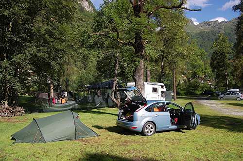
Alagna campsite
APPROACH TO THE ROUTE
Swiss side
Monte Rosa showing Swiss approaches to Italian Normal Route
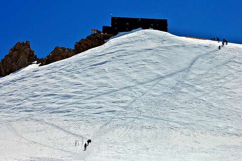
Zermatt 1600m to New Monte Rosa Hut 2883m:
Take Gornergrat Cog Railway to the penultimate stop at Rotenboden 2815m. From here a signed path heads ESE in a descending traverse towards the vast Gorner Glacier. The final descent to the glacier has varied over the years according to the state of the ice, but as of 2013 involved down-climbing steep slabs using ladders and chains – and finally crossing a small metal bridge to reach the ice at about 2500m.
From here – again, the route has varied over the years - but can be expected to be clearly marked with posts and wands. As of 2013, the route crossed the junction of the Gorner and Grenz Glaciers over a chaotic jumble of medial moraine, before following east bank of the Grenz Glacier now – weaving around wide crevasses. The route leaves the ice and after a short scramble across moraine, ascends a clearly marked trail, initially up rock slabs, but then lateral moraine crest to the silver construction of the new Monte Rosa Hut at 2883m. About 3 hours from Rotenboden.
Routes accessing Dufourspitze SE Ridge from Monte Rosa Hut:
1) Ascent of Grenz Glacier to Margherita hut to access lower end – and an ascent of SE Ridge. PD minus. 5-7 hours.
2) Ascent of Swiss ‘normal route’ Monte Rosa NW flank/W Ridge to Dufourspitze summit – traversing Monte Rosa, with a descent of SE Ridge. PD+. 6-7 hours.
3) Ascent of Nordend via Monte Rosa NW flank/Silbersattel/S Ridge to Nordend summit. PD. 5-7 hours. Ascent of Dufourspitze from Silbersattel – AD III without fixed rope (AD minus ‘with’), 1-2 hours.
Italian side
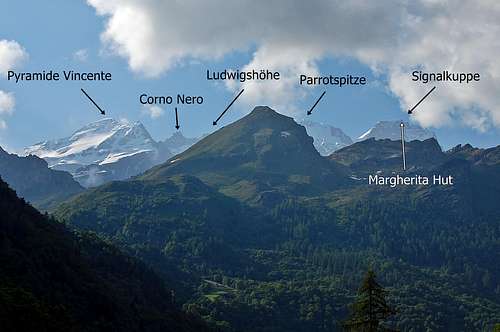
Monte Rosa tops and Margherita Hut from Alagna
Alagna 1212m & Gressoney 1635m to Gnifetti Hut 3647m:
Take gondola from Alagna, or gondola from Gressoney, to Passo dei Salati (2970m), walk round the mountain for about 500m and then complete the final cable car ascent onwards to Indren Lift Station at 3275m.
From Indren, cross the glacier to lower end of a prominent rock spur descending from Pyramide Vincent. Following the trail beyond scramble upwards to first the Mantova Hut (3498m) in an hour or Gnifetti Hut (3647m) in about an hour and a half.
Routes from Gnifetti Hut to Signalkuppe/Margherita Hut:
(If Mantova Hut is used as start point, add another half an hour to the times)
1) By-passing ‘the tops’ – proceeding to Margherita Hut by shortest possible route, via the Lisjoch (4151m). 960m ascent. Grade F. 3 ½ - 4 ½ hours.
2) ‘Traverse of the Tops’ – as described in (UK) Alpine Club Guide by Martin Moran. Depending on conditions and stamina any or all of the following summits (click for links to SP pages) can be taken in en route to the Margherita Hut:
- Pyramide Vincent 4215m/13,828ft.
- Corno Nero (Schwarzhorn) 4321m/14,176ft.
Taking in all the tops is a fabulous expedition, ups overall ascent to about 1200m and increases time to Margherita Hut from about 4 to 7 hours. Grade increases to PD+.
Note that the Balmenhorn 4167m can be easily added in, with a ¼ - ½ detour from near to the final pinnacle of Corno Nero. With a prominence of 15m, this is scarcely a summit, but it has the interesting features of a massive statue of Christ and the Giordino Bivouac Shelter – as well being a good view point.
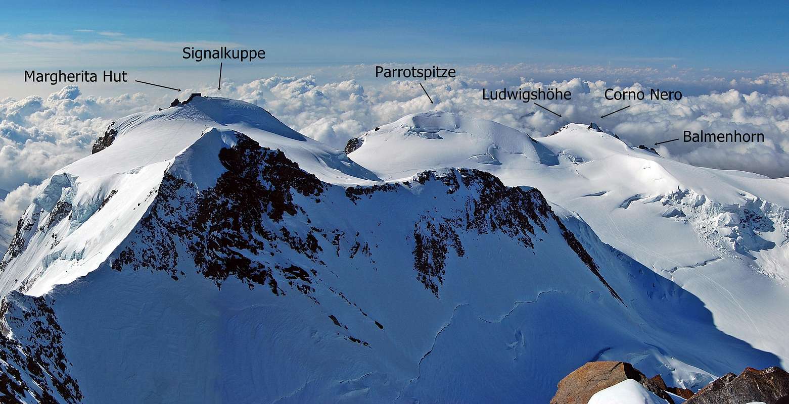
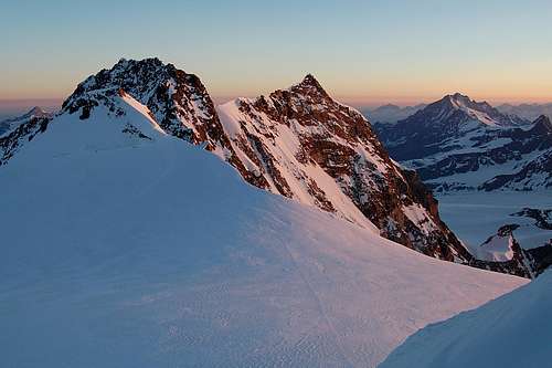
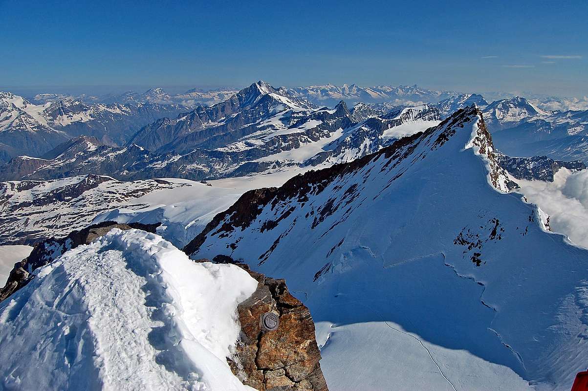
"Traverse of the Tops" Monte Rosa summits, as seen from Dufourspitze summit 4634m. All summits visible apart from Pyramide Vincent.
HUTS
Monte Rosa, Italian normal route - principal huts
Principal huts listed below. All have a SP page - click name to access.
Opened 2009 – silver ‘environmentally friendly’ 5 story structure running on solar power. Tel +41 (0)27 967 2115. SAC Monte Rosa. click for website + on-line booking.
Large hut with 176 places. Quite high – acclimatisation therefore important (see section on acclimatisation below).Tel +39 0163 024610 – CAI Varallo Sesia – click for website + on-line booking. Note that Mantova Hut is an alternative to Gnifetti Hut – or a slightly lower option for those not confident on level of acclimatisation (see section on acclimatisation below).
Bivacco Giordano 4167m – Balmenhorn.
Tiny emergency shelter just below the big metal statue of Christ on the top of the rocky rognon of the Balmenhorn. Places for 8. Bivvy equipment and excellent acclimatisation advisable (see section on acclimatisation below). This is situated about 2 hours above Gnifetti Hut and therefore has potential to halve time taken to reach Margherita Hut by fastest route – and knock 2 hours off time taken to complete ‘Traverse of the Tops’.
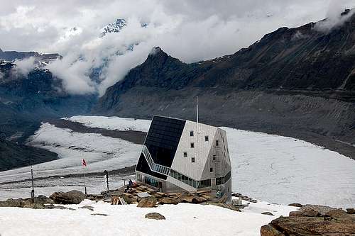
Margherita Hut 4554m – Summit of Signalkuppe
Situated right at the summit of the Signalkuppe and has the accolade of being the highest hut in the Alps – and possibly one of the oldest having opened for business in 1893! Places for 70 – and excellent acclimatisation required to spend a night here (see section on acclimatisation below). This hut is the spring-board for the Italian Normal Route SE Ridge for the Dufourspitze.
Tel +39 0163 910 39 (hut), +39 0163 024610 (bookings) – CAI Varallo Sesia – website + on-line booking
New Monte Rosa Hut 2883m
Margherita Hut on summit of Signalkuppe 4556m
ROUTE DESCRIPTION - ASCENT
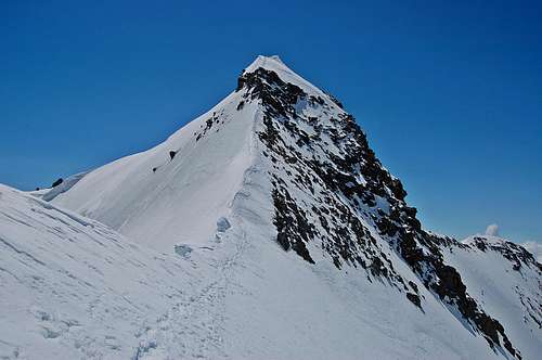
Dufourspitze SE Ridge 2013 view of route from Zumsteinspitze summit
This is more of a high level traverse than an ascent since only 300m of climbing is involved if the Margherita Hut is used as the starting point.
Grade: AD (Assez Difficile) with rock up to III.
Time: 3-3 ½ hours from Margherita Hut, 7-8 hours from Gnifetti Hut – or 5-6 hours from Bivacco Giordano on top of the Balmenhorn.
Description: First descend the easy slopes from Signalkuppe to the Colle Gnifetti (4452m).
Sunrise view of Colle Gnifetti from Margherita Hut
Al C’s photo of ascent of Zumsteinspitze with east face as back-drop
After crossing the col, ascend Zumsteinspitze 4563m via attractive SE ridge. Initially this is a snowy crest – giving way to a mild rocky scramble just below the summit. All the way up the little ridge is the awesome back drop of the East Face of the Monte Rosa Massif.
The summit of the Zumsteinspitze is a fine view point from which to observe the route to the top of the Dufourspitze, which thus far has been mostly hidden from view.
The next part of the route involves a short section of gently sloping snow crest, before an awkward rock step – and then a steep snow crest leading down 110m to the Grenzsattel at 4453m.
At the Grenzsattel the crest is prone to cornicing on the eastern side and thus safest option may be to drop down slightly and traverse along the top of the slopes of the western side, which may be up to 70° steepness up close to lower rocks of the Dufourspitze. In a good season there will be a trail to follow. In a bad season too much snow may result in excessive cornicing and perhaps unacceptable levels of danger - or conversely too little snow may mean dangerously icy conditions at the Grenzsattel.
Al C’s photo of Grenzsattel 4453m - after descent of Zumsteinspitze
Upper part of the Italian normal route from just above Grenzsattel
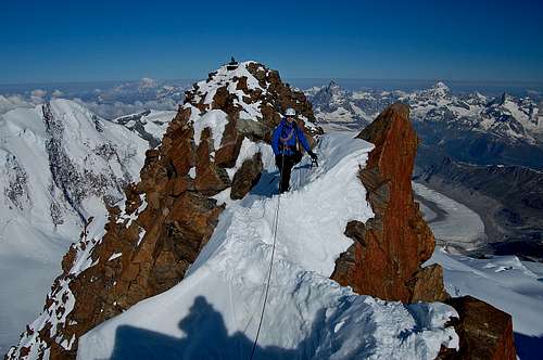
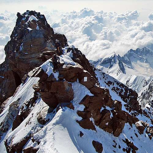
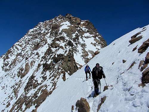
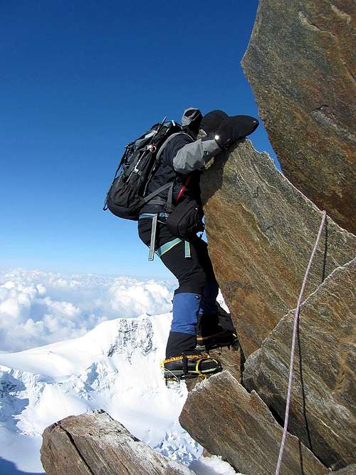
The lower rocks are the start of the SE ridge proper – and soon the terrain becomes quite steep – for the final 200m ascent to the summit.
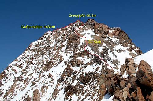
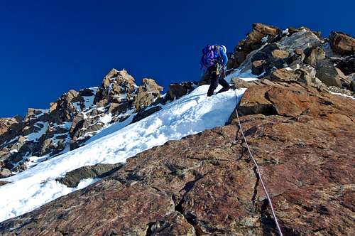
Two small buttresses are turned on the left, before a section of steep snow crest leads up to ‘the grade III slab’. This is climbed diagonally from R to L following obvious polish and crampon scratches on the reddish coloured rock.
Above the slab is a short snow field followed by mixed ground leading up and slightly L into a very shallow gulley between a subsidiary summit on the R and the higher Grenzgipfel (4618m) on the L. The route now heads straight for the small depression (almost a ‘col’) between these two features – before angling L and up to the top of the Grenzgipfel.
At this point it may seem as if the summit of Monte Rosa has been reached. However the true summit, the Dufourspitze, is all of 16m higher – and depending on which guidebook you read 130-150m further away to the west, along the very narrow and serrated summit crest.
 Al C climbing at the top of the Grade III slab in 2013 Grenzgipfel back L.
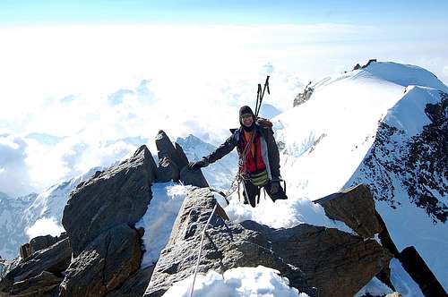
Rob G happy at reaching top of Grenzgipfel - but it isn't the summit
A little way along the crest after the Grenzgipfel and dropping precipitously down to the right, is the route down to the Silbersattel and Nordend. The top of a line of thick fixed ropes is visible starting a few metres down below the crest.
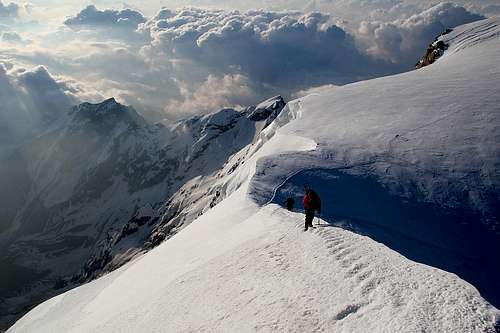
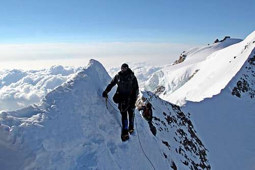
The 130-150m of summit crest between the Grenzgipfel and Dufourspitze is rated at AD minus. It is electrifyingly exposed, with a series of delicate little snow crests and rock teeth. It is not overly difficult, until the final rock step, which involves an off-balance move downwards and to the left (south), just before the last easy scramble up to the summit of Switzerland (the international border from Italy is crossed at the Grenzgipfel).
Note that the last awkward rock move may be avoided by dropping down onto the very steep snow and mixed ground to the right (northern side) of the crest – if conditions permit – not a good idea if snow is very soft.
Al C with summit behind – the awkward move hidden in between
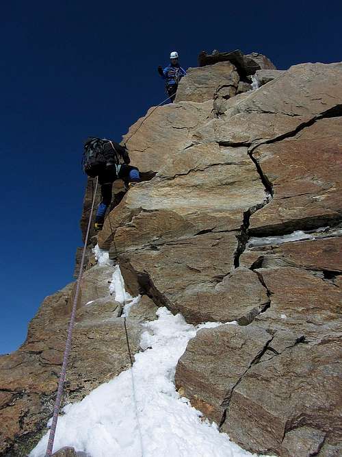
Two climbers just about to tackle the awkward move
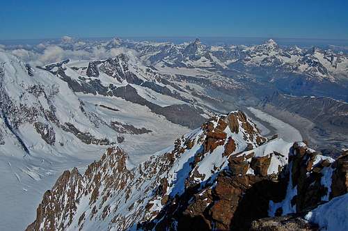
SUMMIT VIEWS
The summit of the Dufourspitze is very small – room for about 4 to share comfortably. The view in all directions is simply fabulous. Just about every 4000m peak in the Alps is visible on a clear day. The only higher summit in view is the great bulk of Mont Blanc, about 70 miles away on the far horizon to the west.
 Summit view to the west 7th July 2013. Mont Blanc on far horizon Summit view to the west 7th July 2013. Mont Blanc on far horizon | 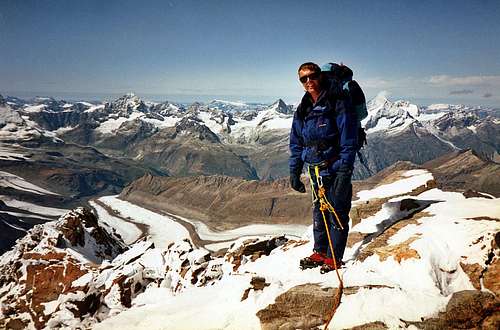 Similar view in late September 1992 Similar view in late September 1992 |
 View to the south east 7th July 2013 View to the south east 7th July 2013 | 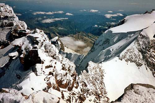 View to the south east late September 1992 View to the south east late September 1992 |
Summit view to north past Nordend to Mischabel group & very distant Berner Oberland.
ROUTE DESCRIPTION – DESCENT
Descent of the SE Ridge of the Dufourspitze is a serious business – especially if it was not used as the means of ascent and is thus relatively unknown. As already stated in the Overview, it is recommended to research conditions thoroughly before even thinking of reversing the route as unseen – since conditions can easily be next to impassable, even when other routes are in condition.
RGG photo: Descent from Grenzgipfel
Descend the short scramble from the summit. The rock step in front may be tackled direct with some difficulty – or as described above, can be turned on L (northern) side. Afterwards, follow the crest for the next 100m+ of delicate snow crests and little rock teeth. The fixed ropes dropping precipitously down to the Silbersattel should be seen down below the crest on the L, just before the final pull up onto the top of the Grenzgipfel.
At the summit of the Grenzgipfel, it is important to angle SE (half right) as well as sharply down now, as departure is made from the crest – and onto the SE Ridge proper. Although it may have been comfortable ‘moving together’ for most of the summit crest, the initial descent from Grenzgipfel is steep and awkward – and it may be advisable for a roped party to move one at a time – down to the small dip in the ridge crest (almost a col) between the Grenzgipfel and the next and lower subsidiary top.
The route now descends mixed ground, angling slightly right – indeed turning most obstacles to the R – until there is a snow patch, which leads to the top of the ‘grade III slab’.
Occasional pitons may be found, which may be of use to belay. There are also plentiful rock spikes from which to hang slings. There should be plenty of ‘polish’ and crampon scratches on the rock, to show the right route, if in any doubt. However, this will not be the case if the route is plastered in icy crust or blown snow – and then if there is poor visibility in addition...
The ‘grade III slab’ is descended R to L – again, following the obvious scratch-marks. Below the slab is another snowy crest – and then mixed ground angling down and towards the Grenzsattel – but generally turning obstacles to the R.
At the Grenzsattel it may be tempting to feel some relief. However, the terrain is still quite steep – and there may well be cornices to avoid, overhanging the East Face. Alternatively it may be icy. Finally there is the sharp 110m pull up to the top of Zumsteinspitze. Initially this is as steep exposed snow crest, but a few metres below the summit is a rock step, which may be awkward, especially if iced. If very lucky it could be snowed over.
At the summit of the Zumsteinspitze, it is now possible to relax – just a little bit. Bar a mildly steep descent to the Colle Gnifetti there is no more technical climbing now. For those who have traversed Monte Rosa from Switzerland there may just be the short easy 100m ascent to the Margherita Hut, to spend the night before descending - back down the Grenz Glacier into Switzerland.
For those returning to the Italian side and Alagna Valsesia, there is a 3-4 hour easy but wearying descent back down to the Gnifetti hut – and beyond a further hour to the cable car at Indren. However, some may chose to spend a night at the Margherita Hut before completing the ‘Traverse of the Tops’ in reverse – if not completed on the way up. The guidebooks seem to recommend this route more for descent than ascent, since the effort involved is less. However, my feeling is that it is aesthetically more pleasing to complete this route coming the other way - as a succession of summits of increasing height.
RGG photo: Returning to the Grenzsattel 4453m
Zumsteinspitze 4563m from Grenzsattel 4453m - note the tricky rock step just below summit.
ACCLIMATISATION
Al feeling the altitude in the Margherita Hut at 4556m/14,943ft
The route described is one of the highest possible routes in the Alps. It involves spending at least 2 nights at altitudes of between 3400m and 4554m. To attempt to do so without adequate acclimatisation is to court Acute Mountain Sickness (AMS) at the least – and at worst High Altitude Pulmonary or Cerebral Edema (HAPE or HACE).
Before even spending the night as high up as the Mantova Hut at 3400m and certainly the Gnifetti Hut at 3600m, it is desirable to have spent one or two nights at or close to 3000m. This could be accomplished though ascent of a high three thousand or low four thousand metre alpine summit elsewhere before embarking on this expedition. Another suggestion could be to break the cable car ascent from Alagna at the Passo dei Salati at 2970m. About ½ hour away from here is another mountain hut:
Vigevano Hut 2865m: This hut is just to the east of the Col d’Olen and about ¾ km from Passo dei Salati. It has 74 beds. If un-acclimatised, it would be a good idea to spend one or even two nights at this elevation – and perhaps climbing the very easy Pyramide Vincent, from here – before moving up to stay at the higher huts.
For further reading on acclimatisation please see my article on Expedition Medicine.
EQUIPMENT
Normal alpine attire – but including duvet jacket, in deference to the very high altitude and potential for extreme cold.
Ice-axe and crampons.
Standard glacier equipment: harnesses, prussic loops, slings with karabiners - and a rope.
Bivvy equipment if staying at the Giordano Bivvy, on top of the Balmenhorn. The other huts are well equipped, provide meals – and so all that is required is to take a sheet sleeping bag. Don’t forget Alpine Club membership card – and passport if descending to a different country to the one you started in.
A few slings are adequate for the rock-climbing on the SE Ridge – but some may wish to carry an additional small selection of rock gear, according to personal preference.
In very icy conditions some may wish to carry a couple of ice-screws - but in average to good conditions these should not be necessary.
Miscellaneous items such as First Aid Kit, Map, Compass – and GPS for devotees of such devices.
WHEN TO GO
Normal summer alpine season is beginning of June to the end of September.
However, in June there may still be spring avalanche danger and approaches to some of the high routes may still be impassable (unless on Ski's) due to deep snow.
In bygone times I would have anticipated summer alpine climbing conditions continuing well on into September. However, in recent years it seems to me that the summer season seems to have been getting progressively shorter: many glaciers becoming impossible due to exposed crevasses and gaping bergschrunds - and the first of the winter storms bringing snow to the lower elevations, seemingly long before the end of the month.
My experience of the past 5 years suggests therefore that optimum months are July and August - but you may get lucky a week or two either side.
REDTAPE
Common sense rules apply, in terms of respecting the environment. No permits are required nor registration with any organisation - but it makes good sense to leave word of your intentions in the mountains at the huts etc. Alpine Club Membership may give discounted rates at some but not all Alpine Huts - suggest check relevant websites.
LINKS/GUIDES
RGG photo: Steep climbing on Dufourspitze, Italian Normal Route
Guide books:
(UK) Alpine Club. "The 4000m Peaks of the Alps - selected climbs" revised 2012. Author: Martin Moran
"The Alpine 4000m Peaks by the Classic Routes" revised 2006. Author: Richard Goedeke.
"Gebietsführer Walliser Alpen", by Marianne Bauer and Michael Waeber, fully revised 14th edition, 2012. In German.
Maps:
Swiss
1: 50000(large edition) No 5006 Matterhorn-Mischabel
1:25000 No 1348 Zermatt
Italian
IGC 1:50000 Cervino - Matterhorn (5); Monte Rosa (10)
IGC 1:25000 Cervino - Matterhorn (108); Monte Rosa (109)
Links:
ACKNOWLEDGEMENTS
I am indebted to rgg aka Rob aka The Peak Monster for his companionship on this route, which involved one of the finest days climbing I have had in the Alps in a 40 year alpine career - but not forgetting Al C, our welsh hitch-hiker, 'picked up' on the Lys Glacier the day before. For more information on this trip please see Alps International Expedition 2013
I am also indebted to both Rob and Al for the use of several of their photos on this page.
Finally, I am grateful to Rob for his help with photo enlargements - and for his customary merciless proof reading. To my shame I am getting used to having my use of my own language corrected by a Dutchman!