
-
 27317 Hits
-
 75.81% Score
-
 6 Votes
|
|
Route |
|---|---|
|
|
38.61926°N / 122.55061°W |
|
|
Hiking, Scrambling |
|
|
Spring, Summer, Fall, Winter |
|
|
Overview
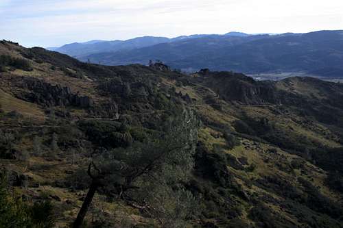
Oat Hill Mine Road as it passes beneath Duff
Oat Hill Mine Road has a deceptive name. The fact that it contains the word “road” in its time may cause some to shy away from it. In fact, it is a road only in its name and in its former life. It was constructed in the 19th century to provide access to a mine in the backcountry high above the community of Calistoga, in the northern end of the Napa Valley. Once the mine played out and trips of the road came to a halt, it fell into disrepair and nature begin to reclaim what hearty pioneers had made. However, because the road was so heavily traveled while the mine was active, Napa County took control of the road and its maintenance. This meant that, despite the fact that most of the route passes through private land; there is a public easement on the road itself, thus allowing the general public to make use of it. Today, the road still passes through private land, except in its very upper reaches where it travels through Robert Louis Stevenson State Park.
Today, the ownership and maintenance of Oat Hill Mine Road is a murky matter. The county still claims jurisdiction over the road. However, at some point in the past, Napa County did quitclaim the easement to the California State Parks. No one is quite sure when or why this happened and it remains an issue to this day. California State Parks are eager to assume management of the road, since it accesses the western end of Robert Louis Stevenson State Park. Furthermore, the park is in negotiations to purchase another 3,000 acres of land east of the present state park boundary. Oat Hill Mine Road would be the primary means of access to this area.
The road is really a road in name only. The lower 2/3rds is narrow single track. While it is possible to make out where the roadbed once was, erosion and plant growth has substantially narrowed the route. Only in its upper stretch is the road wide enough to be considered a round. However, this is the roughest, rockiest part and it would take a high clearance 4x4 to travel it. Interestingly, the ruts from wagon wheels can be found in this upper area.
Getting There
From downtown Calistoga, simply drive north on the main street, which is Highway 29. At a stop sign on the outskirts of town, the highway intersects the Silverado Trail. The trailhead is located on the northeast side of the intersection. Parking is located in the dirt lot in the southwest corner of the intersection.
Route Description
One attractive aspect of the routes history as a road is that it has a very moderate grade. From the trailhead in Calistoga, it climbs 1,900 feet in 4.8 miles. This makes an ascent a reasonable proposition.
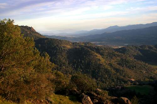
Looking towards the Palisades and Duff from Calistoga
Oat Hill Mine Road begins on the outskirts of downtown Calistoga, at the intersection of Highway 29 and the Silverado Trail. A few houses lay below the trail for the first few hundred yards, but they are swiftly left behind as the trail climbs above the Napa Valley. The trail makes an extended switchback up the first hill and then turns north, quickly entering the backcountry. After the first 0.25 miles, the trial travels under the forest canopy will not exit it for the first couple of miles. Only a few sporadic clearings provide views of Calistoga and its surrounding vineyards. This section of the trail passes a small drainage, although little of the canyon can be seen. Soon the trail rounds a bluff and enters into Simmons Canyon. The route will remain high above this canyon for the duration of the trip, with Duff rising above the upper end of the canyon.
Shortly after passing into Simmons Canyon, the canopy clears and the views open up substantially. Napa Valley spreads out to the southeast, with the Mt. Diablo a brooding presence in the distance. The views of the valley will remain a constant presence until one reaches the southern flanks of Duff. However, the views will constantly change as the trail undulates along the canyon walls. The view of Napa Valley from just below Duff is among the best.
The Napa Valley and Mt. Diablo from Oat Hill Mine Road
2.5 miles from the trailhead, the Oat Hill Mine Road passes through a small glade of trees as it rounds another small bluff. Once it emerges from the glade, Duff and the Bald Hill come into view for the first time. Duff lies due north while Bald Hill is the grassy knob to the northwest. The northern end of Bald Hill has the first good crags visible from Oat Hill Mine Road. The hill is on private property, but the owners have not seemed to mind people making a quick trip to the top. Views of the Palisades from the top of Bald Hill are excellent.
The southern ramparts of Duff are reached 0.75 miles after the peak first comes into view. Prior to reaching ramparts, the trail begins to get rockier and wagon ruts are visible in the volcanic rock roadbed. One the southern end of Duff has been reached, one can climb through the crags to make an ascent of the peak. For the less intrepid, simply proceed up Oat Hill Mine Road until almost below the peak and simply head up the grassy slope to the top. Once Duff’s southern crags are passed, the Palisades come into view for the first time from the trail. Their long band of volcanic cliffs extends to the west and Mount Saint Helena is visible looming above. It is an impressive vista that will continue as the route passes along the western flanks of Duff until the junction with the Palisades trail at Holm’s Place.
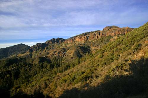
The Palisades from the lower flanks for Duff
At Holm’s Place, the trail enters the saddle between the Palisades and Duff and the views are swallowed up in the lush forest that shelters the ruins of the homestead. The large grassy areas are watered by springs. Oat Hill Mine Road continues another 0.6 of a mile, passing along the extreme eastern end of the Palisades. The trail terminates at Maple Spring. Camping used to be allowed here but regulations changed a decade ago that prohibit overnighters. The state park intends to build a backcountry campsite nearby once the appropriate land is purchased. From Maple Spring, it is possible to travel up the ridge to the west and summit the Palisades eastern highpoint, which is only 2 feet lower than the western highpoint.
From Oat Hill Mine Road, one can take the Palisades trail west to Lasky Point, or to Table Rock. From Table Rock, the Table Rock trail climbs up to Saint Helena Pass and Highway 29. A shuttle is necessary to complete this route and it is strongly suggested that the Table Rock trail be used as the beginning of the route, followed by the Palisades trail and a descent down into Calistoga via Oat Hill Mine Road.
Map
