
-
 20753 Hits
-
 83.1% Score
-
 16 Votes
|
|
Route |
|---|---|
|
|
38.64268°N / 122.58178°W |
|
|
Hiking, Scrambling |
|
|
Spring, Summer, Fall, Winter |
|
|
Overview
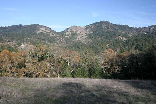 Table Rock
The Table Rock trail is among the most interesting in the California Wine Country. When joined with the Palisades Trail and the historic Oat Hill Mine Road, it is part of one of the most spectacular trails available in wintertime, when the high country is covered in snow. The Table Rock trail combines interesting trail engineering with constant, spectacular views. Vistas along the trail include Mount Saint Helena, Snow Mountain, the Sierra Nevada, the Napa Valley, and the wilderness of badlands above Table Rock. Bizarre rock formations and a pygmy knobcone pine forest also enhance the interest along the route.
The Table Rock trail begins directly across Highway 29 from the trailhead that leads to the summit of Mount Saint Helena. Both trails are in Robert Louis Stevenson State Park. The park is so named because the famed author spent his honeymoon in a small cabin on the slopes of the mountain, as well as spending a significant amount of time in the Napa Valley. His was the pen that wrote the famous description of Napa Valley wines, “…and the wine was like bottled poetry.” His book “Silverado Squatters” recounts his experiences in the region.
Getting There
From Calistoga, proceed north, out of town, on Highway 29. The highway immediately veers west and passes through numerous vineyards at the base of the mountains. Table Rock and the Palisades are prominently visible. Continue west on Highway 29 for a few miles. The highway will begin its torturous ascent up to Saint Helena Pass. This road is EXTREMELY convoluted and many people speed up and down it. Care should be taken. Near the pass, signs will proclaim entry into Robert Louis Stevenson State Park. Immediately after these signs, turn into parking lots on either side of highway, the right side being preferred. From the parking lot, the trail departs to the east.Route Description
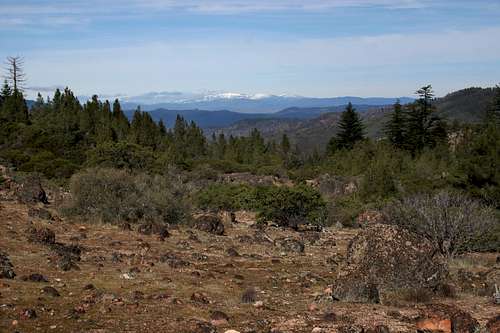 Snow Mountain from the Table Rock trail
The Table Rock trail is 2.3 miles from the trailhead to the summit of Table Rock. The trail begins climbing immediately through a typical northern California hardwood forest. Trees include oak, bay, madrone as well as an occasional pine. The grade is moderate and follows an old roadbed. The first opportunity for views comes about 0.25 miles from the trailhead, where the trees clear and a rocky outcropping provides an excellent vista of Mount Saint Helena to the west and the Snow Mountain massif to the north. If hiking in winter, Snow Mountain is likely covered in its namesake, giving the view a far-reaching, alpine atmosphere, in spite of the relatively low elevation. A little further up the trail, one can look back and see Cobb Mountain and Boggs Mountain. Shortly after this point the trail passes through a short switchback. A signpost marks the trails route. From the first switchback, a use trail splits off to the left, leading to a nifty set of crags.
Following the switchbacks the trail begins to get steeper. In short order the trail finally tops out on a ridge. A signpost marks the distance to Table Rock as being 1.3 miles from this point. Views to the east open up and Bear Valley spreads out beneath the ridge. A few yards further down the trail is a craggy outcropping called “the turret”. The rocks appear like crenellations on a castle’s turret. This is the Table Rock trails highpoint. From here one can look east and see the high peaks of the Desolation Wilderness in the Sierra Nevada in the distance.
 Bear Valley from the Table Rock trail
From the Turret the trail begins to descend steeply, passing over a slick clay-like rock called greywacke. This rock is common throughout the North Coast Range. At the bottom of the descent from the Turret the trail passes through a rock garden. Hikers have stacked and organized the stones into towers and designs throughout the area. The centerpiece of the rock garden is a stone spiral. Snow Mountain is again visible to the north, beyond the rock garden. Departing the garden, the trail is swallowed up by knobcone pine and manzanita. It continues to descend, but now swings to the south. The forest soon recedes away from the trail and bizarre crags protrude from the ground around the trail, hinting that Table Rock lies near. If hiking the trail in the winter or spring, one can often hear rushing water near the crags. Exiting the trail to the right, below the first large crag, one can follow the clearing to the top of an attractive 20 foot waterfall.
Departing the crags, the trail resumes its descent, as it enters Garrett Creek Canyon. The trail actually begins to descend into the canyon at the rock garden but this has not been apparent until now. On the other side of the canyon, the first glimpse of Table Rock can be had. Alongside the trail, one may notice a surprisingly out-of-place telephone box. It is uncertain how or why this was placed here, since there are no buildings anywhere nearby. Nonetheless, it makes a handy trail marker, since the route to the base of Table Rock splits of the main trail here.
 Mount Saint Helena towers above the summit of Table Rock
To reach the base, follow the faint use trail to the west. In short order the route crosses Garrett Creek and joins with an old, unmaintained jeep trail. Follow the jeep trail for about 100 yards. A use trial can be seen climbing a grassy slope above the jeep trail. Take this route and pass through a gully. Beyond the gully, Table Rock begins to rise impressively above the route. The slope beneath base of Table Rock is quite steep. From the bottom of Table Rock one can survey the various climbing options. To reach the summit without climbing the face or returning all the way to the trail, return to the gully and climb to its head. The route eventually dead ends at the bottom of Table Rock’s north shoulder. Climb up the cracks to reach the summit.
Returning to the main trail, the route continues past the telephone box to the bottom of Garrett Creek Canyon. Cross the creek and begin climbing again. The forest canopy is thick, being on the sheltered north slope of the canyon. On the south side of the canyon, manzanita and knobcone pine dominate, while on the north side lush hardwoods provide shade. The trail eventually crosses and then parallels a small creek that drains one of the Palisades highpoints, towering high above. On the right side of the trail, the rock that composes Table Rock begins to be exposed. The trail finally reaches a bench, where a sign marks the beginning of the Palisades Trail. No formal trail exists on the summit of Table Rock but it is easy to pick a route from the bench to the top of the formation. Strange rock formations and unusual stones give the summit a lunar feeling. Mount Saint Helena towers majestically to the west, while the north end of the Napa Valley spreads out to the south. The ordered squares of the vineyards are particularly attractive from the summit.
From here one as two options. The first is simply to retrace ones steps to the trailhead. A better option is to continue on the Palisades trail. This route continues the spectacular views and includes more excellent rock formations and interesting trail engineering. This route can be taken as far as desired before returning to the Table Rock trailhead. The best option, however, is to arrange a car shuttle and take the Palisades trail all the way to Oat Hill Mine Road, which deposits one at the outskirts of downtown Calistoga.
Climbing Table Rock
 The west face of Table Rock
Climbing beta for Table Rock is difficult to acquire. Nearby Mount Saint Helena has four well known climbing areas: the Bubble, the Bear, the Ganja Rocks and the Quarry. The Bubble and the Bear in particular are common climbing destinations. Table Rock is visible form these formations, and it is no doubt that many climbers have looked to the east and wondered at the tall, mysterious cliff. Up close, anchors bolted in the face of the west cliff are clearly visible, so it is certain that some climbers have definitely spent time on it. However, the mountain has a reputation for having bad rock. Proprietors at a local climbing gym in Santa Rosa have hinted at this. First hand investigation has confirmed that the bottom 7.0 – 8.0 feet is indeed bad. However, above this band of crumbly rock there seems to be solid rock. The summit is certainly solid. There are numerous boulders and ledges at the base of the cliff that can be used to rise past the crumbly band at the base. Moreover, the rock that constitutes the nearby Palisades is akin to that which forms Table Rock and the Palisades rock is good. Conversations with State Park personnel have disavowed a formal condoning of climbing on Table Rock on the grounds of bad rock, but they do admit that people do it and there is not move to prohibit it.
Of course, anyone desiring to attempt climbing on Table Rock does so at their own risk.
Map
