
-
 3618 Hits
-
 71.06% Score
-
 1 Votes
|
|
Route |
|---|---|
|
|
46.65680°N / 12.80620°E |
|
|
Hike and Scramble |
|
|
Half a day |
|
|
Walk-Up |
|
|
Approach
See the main page for the general "Getting There" information. You need to leave B111 southwards between Liesing and St. Lorenzen to get to the village of Obergail. Drive on through to the end. There is a restaurant - "Mühlenstüberl" - 200m after which you will find ample parking space. The trail is marked 13, later 19.
Route Description
- Start altitude: 1174m
- Summit altitude: 2251m
- Prevailing exposition: N
- Type: 2h over forest roads. 2h over paths
- Protection: marked
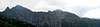
From the Mühlenstüberl Restaurant follow the forest road into Obergailer Tal. It descends to the creek running through the valley. Here a second forest road turns east in the direction of Steineckenalm (route to Liesinger Hochalm). Go straight on following the road through Obergailer Tal. It leads you to Obergailer Alm at the end of the valley.
Behing the Alm a marked footpath (No 19) turns of to the left (east) and starts to climb the flanks of Mittagskofel. It is sparsely marked so watch out for any signs. In the end it leads to a little lake at which it splits. The southern route takes you to Obergailer Joch, one of the important passes of the Carnic Alps Main Ridge. The other, which you have to follow, carries you directly to Mittagskofel. Directly means that it is the shortest possible way - the ascent turns into a steep scramble along wet and slippery slopes. It levels somewhat near Fleckenhütte, which is located 250m below Mittagskofel to its west. Shortly after the hut the path joins the route from Liesinger Hochalm, turns south again, circles the summit block to reach it from the south.
 |  |  |
Essential Gear
Normal hiking gear is sufficient. Trekking poles are advisable for the steep scramble below Fleckenhütte.