Add Heading Here
![Marmots playing on the Sahale...]()
Early in the nineteenth century, explorers and prospectors tramped over Cascade Pass in search of gold and fortune. Cascade Pass was the only thing separating Eastern from Western Washington for American Indians and settlers. Located just outside the city of Marblemount, Cascade River Road leads hundreds of hikers and climbers to the base of many peaks and glaciers every year. Marblemount received its name in 1890 from area resident Matilda Clark Buller. One day a miner told her, Mrs. Buller, I have just discovered a mountain of marble,” and Mrs. Buller said, “Then we should name our town Marblemountain.” A few years later it was shortened to Marblemount. Once you leave Marblemount and travel across the bridge, you find yourself at the Cascade Pass Trailhead in 22 miles. But this season things were much changed. In the fall of 2003, major flood damage and many avalanches destroyed a section of the road to the pass. This made it quite a challenge to visit some of these peaks in the early season, when it is best to travel on glaciers or snow (rather than scree or annoying boulder fields). When the early prospectors challenged these rugged mountains in the late 1800s, they found themselves in awe upon arrival at Cascade Pass.
“After five days of weary plodding we reached the summit of the Cascade River Pass, and a more enchanting scene our eyes had never before gazed upon. Mountains piled upon mountains, stretching away in every direction, presenting the most startling scene imaginable. A silence that was impressive pervaded the scene, except on occasion when an avalanche of thousands of tons of ice, snow, and rocks, breaking from their anchorage in a higher altitude poured down the mountain side into some dark, invisible cavern, below. In the night, on the occasion of our visit one of these avalanches occurred, accompanied by a thundering roar so terrific as to awaken us from a sound sleep and lead us to almost believe that the world was coming to an end.” (Skagit River Journal, 1926)
From the Cascade Pass Trailhead, it takes about 34 switchbacks and 3.7 miles to reach Cascade Pass. Our group decided to do the early season climb in June, parking our car at the site of the road closure 3.5 miles below the Cascade Pass trailhead (the road is now reopened—see page 7 for details). The farthest you could drive the road was to the gated Eldorado trailhead at milepost 19.5. We figured it would only be a few extra miles and little vertical gain. After parking the cars we started walking the road. Though I had been to Cascade Pass a handful of times, I had never stopped to think about all the vertical I was doing in my car. The road is steep and seemed quite long, but we arrived at the Cascade Pass trailhead in about an hour. Here we rested and got ready for the trip up to Cascade Pass.
Having been here many times, I still like to think that these are some of the best views you can find at a trailhead: Johannesburg Mountain looms over you at 8,220 feet. The ruggedness of the mountain is raw, and the hanging blue glaciers just sit there, waiting to be released at any moment and avalanche into the valley below. After a short break we got ready to go and headed up the trail. I was leading our group of seven climbers, and after just 15 seconds of hiking I turned a corner and almost shook hands with a black bear. I stopped in my tracks as the bear pounced at the ground between us with its front paws in a defensive posture. Then he started backing up. We did the same thing, back to the parking lot 15 feet behind us. This was the closest I had ever been to a bear. Last year I got between a mother and her cub near Clark Mountain, but those bears were 100 feet away. It only took a few seconds for us to regroup and try to figure out what to do. The bear was blocking the trail and did not look like he wanted us to pass. A few minutes later two park rangers who were stumped on how we reached Cascade Pass trailhead greeted us. We informed them of our encounter with the bear and they investigated skeptically. Within minutes they were alarmed that there was a bear in the middle of the trail, and proceeded to make the bear go away, using the universal bear deterrent call: “Go away, bear! Go away, bear!”
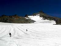
Before we knew it we were on the trail and headed up to the pass. The majority of the snow had melted so it was easy going until the last switchback before the pass. Once at the pass we were greeted with a brisk easterly wind coming off the glaciers and snowfields nearby. We changed from shorts to pants and headed up toward Sahale Arm. The sign says that it is 2 miles from Cascade Pass to Sahale Glacier Camp, and this is one of the few that I must disagree with (I’d say it’s closer to 3 miles). I guess I need to bring a pedometer next time I do this trip and prove them wrong. The trail is narrow and steep in sections before gaining Sahale Arm, with several steep snow crossings that had not melted out. We finally gained the arm and slowly made our way to camp. We still had no views; overcast weather and clouds encircled us the entire day. We lost the trail and began the final half mile to camp in scree slopes and boulder fields. Not much snow had lingered this year, and snowmelt seemed earlier than usual. I had tossed around the idea of bringing my skis on this climb, but had received beta from a fellow skier that most of the run had melted out and would be worthless by the time we got up there. I was thankful for this information, as we did see a solo skier up there later the next day who did not look too excited at the small portion of skiing available. We finally arrived at camp six hours after we had left the trailhead, only to find an empty camp with some killer campsites available to us, something that would be much more difficult when the approach is shorter. We made camp, ate dinner, told jokes and prepared for the morning’s summit bid. The Sahale Glacier route has long been known to be a great introductory mountaineering route. The glacier is somewhat benign, with only a few crevasses, and a gentle slope that leads to easy, class 4 and 5 rock climbing to gain the summit. It is great training ground for anyone interested in learning more on a guided climb, or trying to figure out if this is the sport for them.
Summit Day
![Summit pinnacle of Sahale...]()
We awoke the next morning at 5:30 to find blue skies and incredible vistas we hadn’t seen the day before. After breakfast and a short snow school for those who were rusty or new, we roped up and made our way up the Sahale Glacier headwall, which kicks back at 30 to 35 degrees. Once you top out, the glacier is relatively flat, so we booked on up towards the summit. A few hundred feet of steeper snow got us past the moat and right up against the rock. One full pitch of easy climbing got everyone on top of the coolest panoramic vista in the area. We relaxed and took in the views of the North Cascades, with Mount Buckner to the northeast, Baker to the northwest and Shuksan to the north. After a few minutes, we decided to head down as clouds kept forcing themselves on us. As we made our way back to the snow, I noticed that the glacier had changed, and that our ascent path had crossed right over a crevasse that was about to open up. There were also several other crevasses that appeared out of nowhere. We decided on a different descent path on the glacier. On our way back to camp, we were happy to get in our one and only glissade, which provided us with at least 500 vertical feet of cold yet fast travel down the snow. Once back at camp, we gathered up our things and boogied out as quickly as possible. The descent seemed to take forever, but we rested at Cascade Pass and then at the trailhead. What seemed to take the longest time was the hike back down to the cars on the steep pavement. We finally reached the cars at 8p.m., only 14 hours of hiking since that morning! Needless to say, all of us were trashed, burnt, or frazzled. In the end, we climbed an 8,700-foot peak, the 33rd tallest in the state, and everyone had a great time.
![North Cascades]()
![Summit pinnacle of Sahale...]()
![Ascending the lower portion...]()
![Ripsaw ridge as seen from the...]()
![Only a few minor crevasse...]()
Comments
No comments posted yet.