
|
|
Mountain/Rock |
|---|---|
|
|
37.87526°N / 107.79381°W |
|
|
San Miguel |
|
|
Mountaineering |
|
|
Summer |
|
|
13432 ft / 4094 m |
|
|
Overview
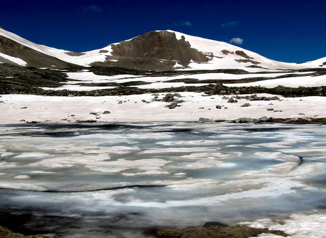
Northeastern face of Oscars Peak from Lewis Lake
Note About Name: This peak is officially unnamed but mountain climbers refer to it as Oscars Peak after a pass by the same name at the southeastern base of its summit.
Oscars Peak rises on the crest of a 6 mile long ridgeline in the San Juan Mountains of southwestern Colorado near the town of Telluride. The ridgeline runs east- west connecting the 13661 ft Lookout Peak to the 13470 foot Silver Mountain. The top of the ridgeline is entirely above 13000 ft. Many other high points/sub-peaks can also be identified along the length of the ridgeline.
Ophir Pass Jeep Road runs to the south of Oscars Peak. This four wheel drive road provides a short cut between Route 550 (north of Silverton) and Route 145 (south of Telluride). To the northeast of Oscars Peak, you will find Bridal Veil Basin, a large alpine basin surrounded by 13000 ft peaks. The 12700 ft Lewis Lake sits at the upper end of the basin. At the low end of the basin, water pours down a 300 ft drop creating Bridal Veil Falls which is said to be Colorado’s tallest waterfall. The beautiful Bear Creek Canyon sits to the northwest of Oscars Peak.
Trails start in or near Telluride and go up into Bridal Veil Basin and Bear Creek Canyon providing access to the summit of Oscars Peak. The southern slopes of Oscars Peak are covered with steep scree fields. An abandoned mining road known as Blixt Road branches off of Ophir Pass Road and goes to the 13130 ft Oscars Pass at the base of the summit providing a walk-up access from the south.
I climbed Oscars Peak as an 11 mile one-way hike from the town of Ophir up Blixt Road into Bridal Veil Basin to end at the bottom of the Black Bear Pass Road switchbacks in eastern Telluride. An approach up, or descent into Bear Creek Canyon can be used as an alternative.
 |  |
Views from the summit of Oscars Peak
 Silver Mountain & The Wilsons
 Town of Ophir & Yellow Mountain
 Vermilion Peak Group
 US Grant Peak & Ophir Pass Road
 Wasatch Mountain & Dallas Peak
 Lookout Peak
 The tip of La Junta Peak, Potosi & Teakettle Peaks
 Bridal Veil Basin, Uncompahgre & Wetterhorn Peaks
 Bridal Veil Basin & Lewis Lake
Route 1, southern slopes via Blixt Road

Directions to the town of Ophir:
From Telluride, CO, drive on main street a few miles west to reach Route 145. Turn south onto Route 145 and drive roughly 7.5 miles to a hairpin turn. On the east side of 145, you will see an unsigned dirt road. Turn left (east) onto this road and drive a little more than 2 miles to the town of Ophir (this section of the road is well graded and is passable by most/any car). Ophir has a western and an eastern section. Go to the edge of the eastern section where four wheel drive begins. (with 4WD you can go another 1.15 miles to the unsigned junction with Blixt Road).
All distances are per my GPS
Hike or drive east on Ophir Pass Road 1.15 miles to reach the junction with Blixt Road.
 Ophir Pass Road
 South Lookout Peak
You will reach a clearing where Blixt Road starts. This junction is not signed. GPS coordinates are 37:51.54 North, 107:48.366 West. Turn left onto this road and go a short distance to a gate that stops the entrance of vehicles. Follow the road 2 miles up to the 13130 ft Oscars Pass. In one place, I had to traverse a large icy snow bank that blocked the road. Views from the road:
 US Grant Peak & V3
 Blixt Road
 South Lookout Peak
 The Wilsons & Lizard Head Peak
 Traversing a snow bank that blocked the road
Once you reach Oscars Pass, follow the southeastern ridgeline of Oscars Peak to its summit.
 Oscars Pass & Oscars Peak
Route 2, northeastern approach via Bridal Veil Basin

Directions to where you start hiking up toward Bridal Veil Basin:
Drive 1-2 miles east on Main Street in Telluride past Idarado Mine structures to a parking area at a switchback where four wheel drive starts. This is the end of Black Bear Pass Jeep Road which comes to this spot from Route 550. A portion of this road is one way from Route 550 to Telluride but with four wheel drive you can drive up the steep switchbacks 2.5 miles to the start of the trail that goes into Bridal Veil Basin.
All distances are per my GPS
Note: This description reflects the fact that I reached the summit of Oscars Peak via Blixt Road and descended down into Bridal Veil Basin. In late June, much of the upper basin was covered by snow. A trail supposedly comes all the way up to the 12700 ft Lewis Lake. I did not see a trail until I was down to 12000 ft. Most of the basin was easy hilly terrain but in a few places I did come across very steep and somewhat difficult slopes. If a trail is visible, these slopes might be avoided.
From the summit of Oscars Peak, I hiked down to the 12700 ft Lewis Lake. You could take any path to reach the lake. There actually seemed to be more than one lake in the area.
Views from lower Lewis Lake.
 La Junta Peak
 Oscars Peak
 Wasatch Mountain & La Junta Peak
I then headed north going down the slopes being careful not to end up in the canyons among the hills.

 Mt. Sneffels seen
At 12420 ft, I reached the remains of Lewis Mine.

The USGS Map showed that the trail went to the west side of the basin but I did not see a trail. Continuing down the basin:
 Lookout Peak
 Tip of Oscars Peak
 Wasatch Mountain
 La Junta Peak
A steep slope I ended up descending and another one I avoided:
 Slope I descended
At 12000 ft, I reached a rough mining road/trail that I then followed all the way down.
At and above tree-line:


Below tree-line:
 Dallas Peak & Mt. Emma


 Avalanche remains
 Avalanche remains
I then reached the junction with Black Bear Pass Road. Many 4WD vehicles had driven up to that spot. I got on the road and began to hike down. Bridal Veil Falls came to view:
 Bridal Veil Falls
 Bridal Veil falls
Telluride and mountain slopes from the road:
 Town of Telluride
At a switchback, the road reached the base of Bridal Veil Falls.
 Bridal Veil Falls
 Bridal Veil Falls
Another stream cascaded down a different slope:

View of Bridal Veil Falls from eastern Telluride:
 Bridal Veil falls from Pandora (eastern Telluride)