This valley, very important for the profile of cultural history, had been
"snubbed" from the point of view of tourism until about forty years ago, being known and preferred destination almost exclusively by vacationers or Sunday's people of Turin City. The new facilities aimed at the ski have completely relaunched and now does not bear comparison with the most famous valleys of the whole Aosta Valley. Although it does not have big mountains or the catchy name like many of the other,
"being content" of
Mont Glacier (3186m),
Mont Delà (3139m) or simply of the opposite
Rosa dei Banchi (3164m) on the border with Piedmont Region. Today in Champorcher Valley and surroundings, oasis of peace in unspoiled nature and understanding of the foothills of the more Southern sector in
Regional Park of Mount Avic, tourists come not only from all over Italy, but from all over Europe.
The Toponimy
As for the place names are a
Bocon d'Amon, the Mont Delà, the Tower Moussaillon or Moutsaillon, the Peradzà, the Rosa dei Banchi and Col Laris or Arial, The Real
which definitely creates curiosity. We would like to translate the name of a mountain pasture, the mountain behind the mountain (Glacier), two unknowns with Peradzà more directed to the patois de Cogne, the Rose of the rocky Banks, where Rosa not signified of Glacier nor of the Rose Flower but rather, in dialect of Aosta Valley little known, "Reiza" or a place very cold. Last but not least the Laris Hill or ancient Salassian name as Arial capable of differentiating their, today "uncertain", road used to enter and occupy Aosta Valley, according to some Historians. While, on the Reale or Royal Lake owes its name to the fact that it is derived from the eponymous pasture, alp wherein the King which whom he had decided to open a mine of argentiferous galena or at least took in turn is named after the King of Sardinia to carry out some "samples" important.
Finally, last but not least Miserin that, taken from the Latin as in Cogne Miserino, really miser, that is poor and as such addressed more Soul than to the body ...
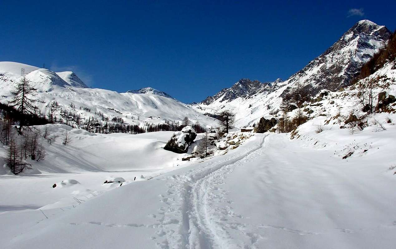
![]() Now on the Royal Road of King Vittorio "Toio" Emanuele II° go to Dondena,
by emilius 2004
Now on the Royal Road of King Vittorio "Toio" Emanuele II° go to Dondena,
by emilius 2004
Indeed it is perhaps the proximity to Barbustel Refuge, not many years now and built in Champdepraz Valley, adjacent to the North with Champorcher Valley.
A vallon, almost a valley, rich in lakes valley that
"binds" itself to Miserin Vallon with its Lake and Sanctuary through a long watershed that, starting from the
Punta Tersiva (3515m) first separates from Clavalité or Valley Fénis and then from the Champorcher Valley dating back wild until you reachs the Mont Glacier, the highest of the entire area. Across the West or towards Cogne's Valley, is
"extinguished" the
Gran Paradiso Chain, while in the South the Rosa dei Banchi is the
"armed guard" with Piedmont, between the
Balma, Rosa Passes and, more to the East,
Larìs Hill, this last between
Bec de l'Asgelas and the opposite
Bec Mollere or Pic Mulère, where in 1799 passed the French Army patrols to encircle the Piedmont behind surprising them with descent to the Orco Valley via Lake of the Royal and those with descent towards the green Valley of Pianprato.
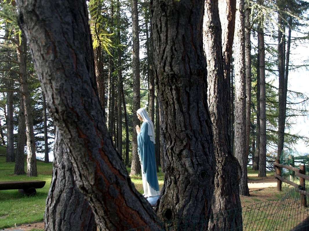
Little Great Madonna on entire balconies of the whole Aosta Valley,
by Osw 2015
![]()
The Sanctuary will stand in front of you cool and quiet and its doors and wooden benches assume a medieval appearance. Far away in time. Waiting to see appear a Friar from the window sash that, looking at you with his head down and with only the chin and mouth coming out of his white cap, invites you with a wave of the hand open to enter. A moment to heat up the fireplace eating something hot. You will not see anyone, and the darkness will fall even further but the road to Dondena is wide and safe. Taken from the rush and despair want to shorten the route and get you on the right fording the Torrent Miserin to fall directly on the path of retreat, passing below the Monte Dondena. Do not do this because it goes well with the light of day; instead follow the wide dirt road that the last light at the horizon make enough suggestive and quietly, even with narrowed eyes, reach Refuge Dondena,
"hidden" under a rocky promontory. Here you will open, if it is not already too far from the Autumn and Winter too close to. In any case do not worry, you are very close to Dondena.
The lights of a bright morning just above Château-Champorcher Commune and welcome you at la Cort very small Village. where you can see the domination of
"Madonna of the Snow".
Royal Route by King "Toio" is "virgin" and his immaculate snow. Put on snowshoes and go. You will not find anyone until Dondena, there around the corner.
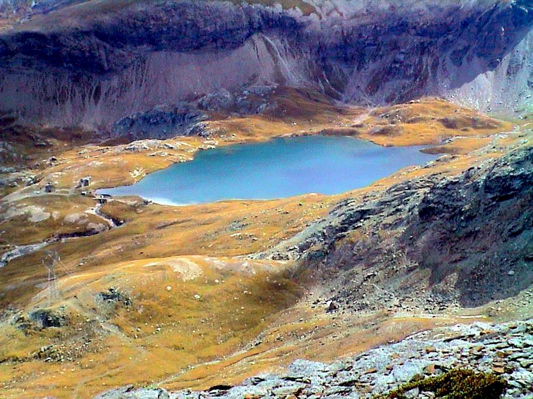
Meanwhile in all this short, but mentally long journey, there will appears the Ghosts of a famous Legend around the lake, perhaps the bluest and azur of the Valley of Aosta, even if it is not the greatest because the Grand Lake is just beyond, hidden behind the pyramids of Mont Glacier and Mont Delà now in the Valley of the Lakes or Champdepraz. Also within the
Regional Park of Mount Avic. This attraction persuaded Mr Pantaleone Savin in 1658 to transform an ancient Oratory (perhaps known since the times of
St. Porciero and San Besso wandering the Theban Legion and surely already famous for the miracles that occurred during the
Plague of 1630) in a Chapel that with time he took on increasing importance, and the same, dedicated to Our Lady of the Snows, became an increasingly popular place of pilgrimage and remembered every year the day of
5 August. In the years 1714 and 1715 took place "terrible" snowfalls that reached 11 meters in height damaging the Chapel and the villagers had to tear down and build the same for a new in 1717, but now in the form of small church with three altars. This allowed to officiate the Mass also by the Parish Priests of the neighboring valleys, a factor which, together with the opening of the road Hunting Reala wanted by
Vittorio Emanuele II° or "Re Toio" in 1862 after the unification of Italy (1861) that combine with Champorcher towards Cogne and vice versa through the Champorcher Finestra (Window) and Pontonnet Hill more to the North, he gave a great impetus to the knowledge and the attendance of the
Sanctuary Miserin. Then the same will not "belong" more exclusively in Champorcher and to the inhabitants of his valley but also became the "property" of those of Cogne and also of the neighboring municipalities of Pont Bozet nowadays Pontboset, Champdepraz (through the hills of the Croce (Cross) and Lago Bianco (the White Lake ) and Fénis (by means of the hill placed at the end of Clavalité Vallon), as well as the nearby Canavese Valleys in Piedmont Region. For this reason the Church, that now had already 150 years, was demolished and the
Abbot Pierre Chanoux, a famous former Parish Priest of Champorcher and then renowned throughout the Valley of Aosta until La Thuile where he performed the duties of Rector of the Hospice of the Little Saint Bernard, he had the idea and made the followed decision with the locals to build a larger Church and adapted to accommodate the ever-growing mass of
Pilgrims. In this task it was aided and supported also by the then current Pastor Don Filiberto Noussan with whom he collaborated to also build a shelter with its dormitory placed on two superimposed and existing plans even today. Also hosting some
hunter of chamois and ibexes (it was not an offense when authorized by the King) and also the hunting of the same King of Italy (famous ones on Window and Pontonnet Hills completed with small stone walls) and even
hikers or explorers mountaineers (from 1848 more and more widespread but not again turned into
true climbers). But the main purpose was not in the pleasures of the body, but safeguarding the souls and this religious order always met more success so much so that the old church (22 metres long, 7 wide and 12 in height) was prolonged and extended by more 4 metres to hold a crowd that already recorded as many as 22 Prelates from the Valley of Aosta and from Campiglia Soana with
over 5.000 Faithful. The same Vittorio Emanuele II°, first King of Italy rose from Champorcher to Dondena and from this last towards the Miserin Lake to attend the Sunday Mass, during which existed and still exists today the custom of selling the charm of gifts with objects various (usually of the local traditional crafts and tools) with a view to contributing towards the maintenance costs of the Shrine and the adjoining shelter. At the inside of the first it was kept a beautiful picture of
"Our Lady of the Snows", as well as a small original statue it. We must use the verb in the imperfect way, since a fire in 1946 had destroyed, along with the Shrine, the one and the other.
Faith and Patience of the men have rebuilt once again the
Sanctuary Miserin even further enlarging the same with the current sacristy against the apse, in addition to the old Sanctuary. Today you will not find the jokes of the Royal Hunting, because the Miserin is
"locked up" between the
Gran Paradiso National Park in Southwest towards Cogne Valley and Piedmont and the
Regional Park of Monte Avìc immediately to the North of the pyramids beyond Mont Delà, Mont Glacier and long watershed until Bocon d'Amon Cima Piana between Champdepraz Champorcher.
But you can find many Hikers and
Nature Lovers or of photography, also accompanied by children or elderly people are still looking for some excitement with a nice & safe walk.
Explorers have totally disappeared because all mountains have been "looted", but appears, unfortunately, the trial bikes on the rounded back of Mont Rascias ...
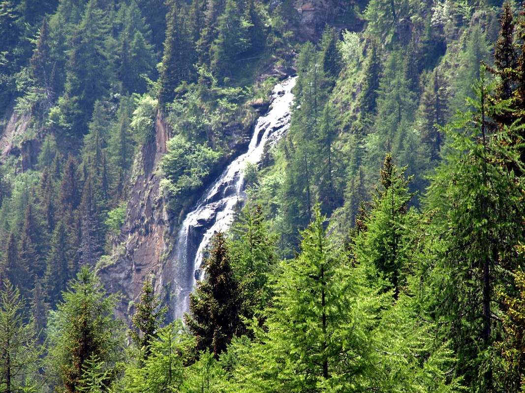
Echellettes Cascade above Chardonney Hamlet & below Dondena Royal Road,
by Osw 2016
![]()
Questa valle, molto importante per il profilo storico-culturale, ma anche dal punto di vista topografico e toponomastico con alcuni nomi degni di indagine.
Infatti la stessa si collega a Settentrione con la Valle di Champdepraz o Vallone dei Laghi, dopo aver superato i
Colli della Croce e del Lago Bianco che permettono di superare quel lungo spartiacque che dal Mont Glacier và a collegarsi alla
Cima Piana, dopo aver scavalcato in successione il
Bocon d'Amon, la Tête des Hommes e la Torretta. Più ad Ovest lo stesso spartiacque si coniuga con il Mont o Tour Moussaillon o Moutsaillon prima di raggiungere la Tour Pontonnet e poi flettere definitivamente sulla
Punta Tersiva (3515 m); questo tratto forma il divisorio con il Vallone della Clavalité o Valle di Fénis, sempre rivolto al Nord. Il tratto successivo costituisce il divisorio con la Valle di Cogne, costituendo le estreme propaggini del
Gran Paradiso, inteso come Catena montuosa vera e propria quindi appendici Orientali e Settentrionali escluse. Oltre a Meridione si distende, tra la
Cima di Peradzà dal triplice confine e la Rosa dei Banchi, vera
"sentinella armata", il confine col Piemonte che dai Colli della Balma e della Rosa s'indirizza più ad Oriente raggiungendo il
Col Larìs tra
Bec de l'Asgelas e Bec Mollère or Pic Mulère, ove nel 1799 passarono pattuglie dell'Armata francese per accerchiare i piemontesi sorprendendoli alle spalle, con discesa verso la valle dell'Orco in Canavese nel Piemonte, passando pel Lago della Reale e da questi con discesa alla verdeggiante e piemontese Valle di Pianprato.
La Toponomastica
Per quanto concerne la toponomastica troviamo un
Bocon d'Amon, il Mont Delà, la Torre Moussaillon o Moutsaillon, la Peradzà, la Rosa dei Banchi ed il Col Larìs od Arial, la Reale che sicuramente creano delle curiosità. Ci sentiamo di tradurre con il nome d'un alpeggio, il monte dietro il monte (il Glacier), due incognite con la Peradzà più rivolta al patois de Cogne, la Rosa delle Banconate rocciose, dove Rosa non signifia Ghiacciaio né tantomeno il fiore della Rosa, ma piuttosto in valdostano poco conosciuto un luogo
"reizà", ovvero molto freddo. Buon ultimo il Colle di Larìs o con antico toponimo dei Salassi di Arial atto ad individuare una loro strada, oggi "incerta", utilizzata per entrare ad occupare la Val d'Aosta, secondo alcuni Istorici. Mentre per quanto concerne il Lago della Reale deve il nome al fatto che é derivato dall'omonimo alpeggio, alpe che prendeva a sua volta il nome dal Re di Sardegna il quale aveva deciso di far aprire una miniera di galena argentifera o per lo meno di effettuarne alcuni "assaggi" importanti.
Buon ultimo il termine Miserin che, preso dal latino e come a Cogne Miserino, significa povero, cioé misero e come tale rivolto più all'Anima che non al corpo ...
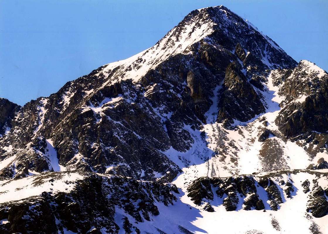
![]() Mont Glacier between Champorcher-Château-Chardonney & Dondena Villages,
by emilius 2000
Mont Glacier between Champorcher-Château-Chardonney & Dondena Villages,
by emilius 2000
Non tardate perché presto farà buio e quando passerete nuovamente presso il Miserin un senso di scuro tremore vi invaderà riportandovi indietro nel tempo.
Il Santuario s'ergerà di fronte a voi freddo e silenzioso ed i suoi portoni e le panche in legno assumeranno un aspetto medioevale. Molto lontano nel tempo. In attesa di veder apparire un Frate dal battente della finestra che, guardandovi a testa bassa e con solo il mento e la bocca che escon dal suo bianco cappuccio, v'inviterà con gesto aperto della mano ad entrare. Un attimo a scaldarsi al fuoco del camino mangiando qualcosa di caldo. Non vedrete nessuno ed il buio scenderà ancor più, ma la strada per Dondena é larga e sicura. Presi dalla fretta e dallo scoramento volete abbreviare il percorso indirizzandovi a destra guadando il Torrente Miserin per scendere direttamente sul sentiero del rifugio, passando al di sotto del Monte Dondena. Non fatelo, perché và bene con la luce del giorno; seguite invece la larga strada sterrata che gli ultimi chiarori all'orizzonte rendon già abbastanza suggestiva e tranquillamente, anche cogli occhi socchiusi, raggiungete il Rifugio di Dondena,
"nascosto" sotto un promontorio roccioso. Qui v'apriranno, se non é ormai troppo lontano dall'Autunno e troppo vicino all'Inverno. Non temete, siete a due passi da Dondena.
Le luci d'un luminoso mattino v'accolgono appen sopra Château e presso la Cort dove potrete ammirare il dominio della
"Madonna della Neve".
La Strada Reale é
"vergine" ed immacolata la neve. Calzate le racchette o, se volete ciaspole, ed andate. Trovate nessun sin'a Dondena, giusto lì dietro l'angolo.
Nel frattempo in tutto questo breve, ma mentalmente lungo viaggio, vi appariranno i Fantasmi d'una nota Leggenda intorno al lago forse più azzurro della Valle di Aosta, anche se non é il più grande perché il
Gran Lago é appena più in là, nascosto dietro le piramidi del Mont Glacier e del Mont Delà ormai nel Vallone dei Laghi o di Champdepraz. Sempre all'interno del
Parco Regionale del Monte Avìc. Questa attrazione convinse il Sig. Pantaleone Savin a trasformare nel 1658 un antico Oratorio (forse noto già ai tempi di
San Porciero e di San Besso della raminga Legione Tebea e sicuramente già celebre per i miracoli verificatisi durante la
Peste del 1630) in una Cappella che col trascorrere del tempo assunse sempre maggiore importanza e la stessa, dedicata alla
Madonna delle Nevi, divenne un luogo di pellegrinaggio sempre più frequentato e ricordato di anno in anno nel giorno del
5 di Agosto. Negli anni 1714 e 1715 avvennero
"terribili" nevicate che raggiunsero anche gli 11 metri di altezza danneggiando la Cappella e i valligiani dovettero abbatterla per ricostruirne una nuova nel 1717, ma ormai sotto forma di piccola Chiesa con tre altari. Questa permetteva di officiare la Messa anche da parte dei Parroci delle vicine vallate, fattore che, insieme all'apertura della Strada Reala di Caccia voluta da
Vittorio Emanuele II° o "Re Toio" nel 1862 subito dopo l'Unità d'Italia del 1861 tale da unire Champorcher con Cogne tramite i Colli Finestra di Champorcher e Pontonnet più a Nord, diede un grande impulso alla conoscenza ed alla frequentazione del
Santuario del Miserin. Quindi il medesimo non
"apparteneva" più esclusivamente a Champorcher ed agli abitanti della sua vallata ma diventava anche
"proprietà" di quelli di Cogne ed inoltre dei limitrofi Comuni di Pont Bozet, oggigiorno Pontboset, Champdepraz (tramite i Colli della Croce e del Lago Bianco) e di Fénis (per mezzo dell'omonimo colle posto al termine della Clavalité), nonché delle viciniore Valli del Canavese in Piemonte. Per questo motivo la Chiesetta che ormai aveva 150 anni venne demolita e
l'Abate Pierre Chanoux, celebre ex Parroco di Champorcher e poi rinomato in tutta la Valle di Aosta sino a La Thuile dove svolgeva le mansioni di Rettore all'Ospizio del Piccolo San Bernardo, avuta l'idea prese la decisione con gli abitanti del posto di costruire una Chiesa più grande ed atta ad accogliere la massa sempre più crescente di
Pellegini. In questo compito venne aiutato e sostenuto anche dall'allora attuale Parroco
Don Filiberto Noussan con il quale collaborò per costruire anche un rifugio con relativo dormitorio collocato su due piani sovrapposti ed esistente pur oggigiorno. Ospitando anche qualche
cacciatore di camosci e stambecchi (non era un reato se autorizzato dal Re) ed anche le illustrissime battute di caccia del medesimo Re d'Italia (famose quelle ai Colli Finestra e Pontonnet con tanto di muretti protettivi in pietra onde occultare i fucilieri) ed anche gli
escursionisti o gli alpinisti esploratori (dal 1848 sempre di più in grande diffusione, ma non ancora tramutati in
veri arrampicatori). Ma lo scopo principale consisteva non nel diletto del corpo, bensì nella principale salvaguardia delle anime e questo fine religioso incontrò sempre più successo tanto che la vecchia Chiesa (22 metri di lunghezza, 7 di larghezza e 12 d'altezza) venne prolungata di altri 4 metri per contenere una folla straripante e che ormai registrava ben 22 Prelati dalla Valle di Aosta e da Campiglia Soana con oltre
5.000 Fedeli. Lo stesso
Vittorio Emanuele II°, primo Re d'Italia saliva da Champorcher a Dondena e da quest'ultima al Miserin per assistere alla Santa Messa della Domenica, durante la quale sussisteva ed esiste ancor oggi l'usanza di vendere all'incanto dei regali con oggetti varii (in genere dell'artigianato tipico locale) con il fine di contribuire alle spese di manutenzione del Santuario e dell'attiguo rifugio. All'interno del primo veniva conservato un bel quadro della
"Madonna delle Nevi", nonché una piccola statua originale della medesima. Dobbiamo usare il verbo al modo imperfetto, poiché un incendio avvenuto nel 1946 distrusse, insieme al Santuario, l'uno e l'altra.
La Fede e la Pazienza degli uomini hanno ricostruito ancora una volta il
Santuario del Miserin, addirittura ingrandendo ulteriormente il medesimo con l'attuale sacrestia contro l'abside in aggiunta al vecchio Santuario. Oggi non troverete più le battute di Caccia Reali, perché il Miserin risulta
"rinchiuso" tra il
Parco Nazionale del Gran Paradiso a Sudovest verso la Valle di Cogne ed il Piemonte e dal
Parco Regionale del Monte Avìc subito a Settentrione al di là delle piramidi del Mont Delà, del Mont Glacier e lo spartiacque al Bocon d'Amon. Ma potete trovare tanti Escursionisti
Amanti della Natura e della fotografia, accompagnati anche da bambini, oppure persone anziane ancora alla ricerca di qualche emozione tramite bella passeggiata.
Scomparsi gli Esploratori poiché tutte le montagne sono state "razziate", compaiono, purtroppo, le moto da trial sù pel dosso "bombato" del Mont Rasciàs ...
![]() Miserere Miserere, Miserin Sanctuary from Ponton Tower, Misere Nos ...
by emilius 2002
Miserere Miserere, Miserin Sanctuary from Ponton Tower, Misere Nos ...
by emilius 2002 Getting There from Pontboset towards the Miserin
By car:
- From TORINO, MILANO, etc: Motorway A5. Exit at IVREA or Quincinetto (PIEDMONT)
From IVREA Town: Pont Saint Martin, Donnas, Hone, Bard, Municipalities.
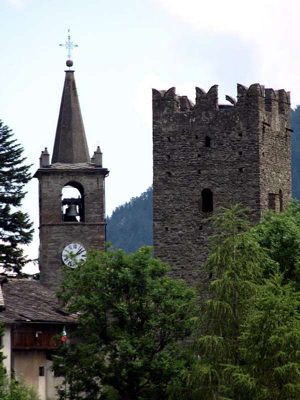
Camporcher-Château Belfry & Tower,
by Osw 2006
![]() Specific Main Road towards Pontboset & Champorcher-Dondena
From Pont Bozet (775m) to Champorcher Valley, Camporcher-Château (1427m), Petit, Grand Mont Blanc, La Cort Villages, towards Dondena Village (2092m), Dondena & Miserin Refuges, through Royal Road & secondary dirt roads; Barbustel Refuge, through Royal Road and path towards Champdepraz Vallon.
Specific Main Road towards Pontboset & Champorcher-Dondena
From Pont Bozet (775m) to Champorcher Valley, Camporcher-Château (1427m), Petit, Grand Mont Blanc, La Cort Villages, towards Dondena Village (2092m), Dondena & Miserin Refuges, through Royal Road & secondary dirt roads; Barbustel Refuge, through Royal Road and path towards Champdepraz Vallon.
- From FRANCE: through the Mont Blanc Tunnel to Entrèves-crossroads to Vény/Ferret Valleys - Mountain Guides of Courmayeur - La Saxe Rock Gym - Courmayeur. By Little Saint Bernard Pass, closed since November until half May to La Thuile Valley - Pré Saint Didier - Courmayeur.
It is not necessary to take Motorway A5: you can drive on State Road n° 26, in the direction of AOSTA - IVREA - TURIN.
By plane:
- Aeroporto Internazionale "Corrado Gex" Saint Christophe (Aosta)
Comments
No comments posted yet.